Maps of Bas-Rhin

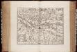
Alsatia tem Svperior, quam Inferior una cum Svndgovia
1 : 120000 Mollova mapová sbírka Homann, Johann Baptist Homann, Johann Baptista - dědici
Partie du Haut Rhein, où se trouvent la Haute et Basse Alsace, Suntgow, Brisgow, Ortenaw, et partie des marquisats de Baden, 1
1 Blatt : 51 x 39 cm de Fer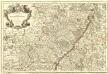
L'Alsace Divisée En Ses Principales Parties.
1 : 250000 Mollova mapová sbírka Jaillot, Alexis-Hubert Jaillot, Alexis Hubert
Departement du Bas Rhin
1 Karte : Kupferdruck ; 16 x 15 cm au dépot de l'Atlas national rue de la Monnoye no. 5
Département du Bas Rhin
1 Karte : Kupferdruck ; 49 x 48 cm Houdan au bureau de l'atlas national rue de la Harpe no. 26, et au dépot du dit atlas rue de la Monnoye no. 5
Département du Bas Rhin
1 : 260000 Bas-Rhin (Francie) Houdan, d' P.G. Chanlaire
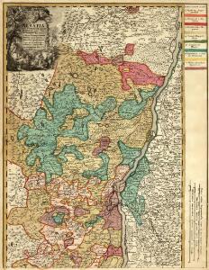
Die Grafschaft Hanau-Lichtenberg mit dem Departement Nieder-Elsas
1 : 180000 Müller, Johann Jakob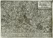
Alsatia inferior
1 Karte : Kupferdruck ; 17 x 27 cm Specklin; Quad Johannes Bussemacher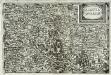
Alsatia inferior
1 Karte : Kupferdruck ; 14 x 22 cm Lambert Andreae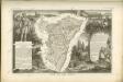

Alsatia inferior
1 Karte : Kupferdruck ; 34 x 42 cm Mercator; Hondius excusum apud Henricum Hondium sub insigno atlantis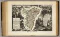
Dept. Du Bas Rhin.
1 : 455000 Levasseur, Victor.
Alsatia inferior
1 Karte : Kupferdruck ; 34 x 41 cm Mercator s.n.
Alsatia inferior
1 Karte : Kupferdruck ; 35 x 42 cm Hondius; Mercator Jodocus Hondius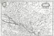
Alsatia inferior
1 Karte : Kupferdruck ; 19 x 29 cm Merian Merian
Alsatia inferior
1 Karte : Kupferdruck ; 17 x 24 cm Mercator; Keere Cloppenburgh
Alsatia inferior [Karte], in: Gerardi Mercatoris et I. Hondii Newer Atlas, oder, Grosses Weltbuch, Bd. 1, S. 244.
1 Karte aus Atlas Mercator, Gerhard und Hondius, Jodocus Jansson, Jan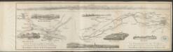
Alsatia inferior [Karte], in: Gerardi Mercatoris Atlas, sive, Cosmographicae meditationes de fabrica mundi et fabricati figura, S. 365.
1 Karte aus Atlas Mercator, Gerhard Montanus, Petrus
Charte von der Grafschaft Hanau-Lichtenberg
1 : 180000 Grattenauer, Ernst C. Grattenauer
Specialkarte Der Gegenden Zwischen Dem Rhein Und Der Saar
1 : 170000 Rheinwald, Johann Ludwig Christian; Dewarat, Peter; Walbert
Tribocci
1 Karte : Kupferdruck ; 39 x 49 cm Sanson; Robert de Vaugondy; Somer chés le Sr. Robert geog. du roi quai de l'horloge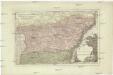
Der District Hagenau
1 : 182000 Haguenau (Francie)
Alasatia superior et inferior III. tabulis delineata, 3
1 Blatt : 62 x 59 cm s.n.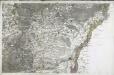
[Strasbourg]
1 Blatt : 60 x 92 cm s.n.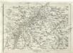
Geographica Provinciarum Sveviae Descriptio =
Mollova mapová sbírka Hurter, Johann Christoph Bodenehr, Johann Georg
169. Strassburg i. Elsass, uit: Topographische Uebersichtskarte des Deutschen Reiches / herausgegeben v. d. Kartogr. Abt. d. Königl. Preuß. Landesaufnahme
1 : 200000 titelvariant: Topogr. Übersichtskarte des Deutschen Reiches; Annotatie: Titel boven bladen ook: Topogr. Übersichtskarte des Deutschen Reiches; Annotatie geografische gegevens: Op elk blad twee maatstokken: 10 Kilometer = 5,5 cm; 1 geogr. Meile = 3,6 cm; Legenda onder op elk blad Königlich Preußische Landesaufnahme. Kartographische Abtheilung [S.l : Königlich Preußische Landesaufnahme, Kartographische Abtheilung]
Partie du Cours du Rhein, ou se Trouvent les Villes de Spire Philipsbourg Landau Hagenau et le Fort Louis, Dessigne et Levee sur les Lieues
1 : 160000 Mollova mapová sbírka Baillieul, Gaspard Bailleul, Gaspard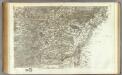
162 Strasbourg.
1 : 86400 Cassini family; Cassini, Cesar-Francois, 1714-1784
Strasburg 127, uit: [W. Liebenow's Special-Karte von Mittel-Europa]
1 : 300000 titelvariant: W. Liebenow's Mittel-Europa; Annotatie: Titel boven de bladen: W. Liebenow's Mittel-Europa Johannes Wilhelm Liebenow 1822-1897 Hannover : Hermann Oppermann