Maps of Bas-Rhin

Alsatia inferior [Karte], in: Gerardi Mercatoris et I. Hondii Newer Atlas, oder, Grosses Weltbuch, Bd. 1, S. 244.
1 Karte aus Atlas Mercator, Gerhard und Hondius, Jodocus Jansson, Jan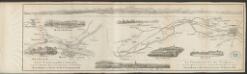
Alsatia inferior [Karte], in: Gerardi Mercatoris Atlas, sive, Cosmographicae meditationes de fabrica mundi et fabricati figura, S. 365.
1 Karte aus Atlas Mercator, Gerhard Montanus, Petrus
Alsatia inferior
1 Karte : Kupferdruck ; 17 x 24 cm Mercator; Keere Cloppenburgh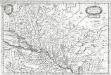
Alsatia inferior
1 Karte : Kupferdruck ; 19 x 29 cm Merian Merian
Alsatia inferior
1 Karte : Kupferdruck ; 34 x 41 cm Mercator s.n.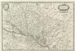
Alsatia Inferior
1 : 440000 Mollova mapová sbírka Merian, Matthaeus Merian, Matthäus
Alsatia inferior
1 Karte : Kupferdruck ; 34 x 42 cm Mercator; Hondius excusum apud Henricum Hondium sub insigno atlantis
Landgraviatus Alsatiae Inferioris Novissima Tabula
1 : 280000 Mollova mapová sbírka Visscher, Nicolaes Jansz. Schenk, Peter II
Alsatia inferior
1 Karte : Kupferdruck ; 35 x 42 cm Hondius; Mercator Jodocus Hondius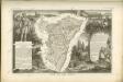

Département du Bas Rhin
1 : 260000 Bas-Rhin (Francie) Houdan, d' P.G. Chanlaire
Département du Bas Rhin
1 Karte : Kupferdruck ; 40 x 35 cm Capitaine s.n.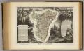
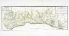
Dept. Du Bas Rhin.
1 : 455000 Levasseur, Victor.
Landgraviatus Alsatiæ inferioris novissima tabula
1 Karte : Kupferdruck ; 45 x 55 cm Visscher; Schenk nunc apud Petrum Schenk iunior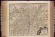
Landgraviatus Alsatiae Inferioris novissima tabula, in qua simul Marchionatus Badensis, Ortenavia caeteraque tam Lotharingica quam alia confinia / accuratissimè describuntur per Nicolaum Visscher
1 : 300000 Annotatie: Cum privilegio Ordinum Hollandiæ et Westfrisiæ; Origineel is Blad 113 in atlas factice; Annotatie geografische gegevens: Schaalstokken: Milliaria Germanica communia, en: Milliaria Gallica communia Nicolaes Jansz. Visscher jr. 1649-1702 [Amsterdam : Nicolaus Visscher]
Alsatia Landgraviatus, cum Suntgoia et Brisgoia [Karte], in: Le théâtre du monde, ou, Nouvel atlas contenant les chartes et descriptions de tous les païs de la terre, Bd. 1, S. 291.
1 Karte aus Atlas Blaeu, Willem Janszoon und Blaeu, Joan Blaeu, Willem Janszoon
Landgraviatus Alsatiae Inferioris Novissima Tabula [...] [Karte], in: Novus atlas absolutissimus, Bd. 2, S. 200.
1 Karte aus Atlas Janssonius Offizin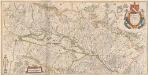
Alsatia Landraviatus, cum Suntgoia et Brisgoia [Karte], in: Theatrum orbis terrarum, sive, Atlas novus, Bd. 1, S. 286.
1 Karte aus Atlas Blaeu, Joan Blaeu, Willem Janszoon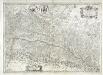
Vtriusquæ Alsatiæ superioris ac inferioris nova tabvla
1 Karte : Kupferdruck ; 37 x 53 cm Janssonius sumptibus Ioannis Ianssonii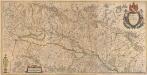
Alsatia Landgraviatus, cum Suntgoia et Brisgoia [Karte], in: Novus Atlas, das ist, Weltbeschreibung, Bd. 1, S. 260.
1 Karte aus Atlas Blaeu, Joan Blaeu, Willem Janszoon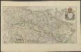
ALSATIA | Landgraviatus, | cum | SVNTGOIA | et | BRISGOIA
Ger. Mercatore | Auctore. Guiljelm. Blaeu excudit.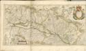
Carte des grandes routes et principales comunications de la province d'Alsace
1 Karte auf 2 Blättern : Kupferdruck ; 27 x 75 cm Weis s.n.
Departement du Bas Rhin
1 Karte : Kupferdruck ; 16 x 15 cm au dépot de l'Atlas national rue de la Monnoye no. 5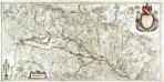
Alsatia landgraviatus, cum Svntgoia et Brisgoia
1 Karte auf 2 Blättern : Kupferdruck ; 38 x 79 cm Blaeu; Mercator Guiljelm. Blaeu excudit
Département du Bas Rhin
1 : 265000 Bas-Rhin (Francie) Houdan, François d' Bureaou de l'Atlas national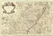
L'Alsace Divisée En Ses Principales Parties.
1 : 250000 Mollova mapová sbírka Jaillot, Alexis-Hubert Jaillot, Alexis Hubert
Département du Bas Rhin
1 : 250000 Bas-Rhin (Francie) Chanlaire, Pierre-Grégoire P.G. Chanlaire
Département du Bas Rhin
1 Karte : Kupferdruck ; 49 x 48 cm Houdan au bureau de l'atlas national rue de la Harpe no. 26, et au dépot du dit atlas rue de la Monnoye no. 5
![Alsatia inferior [Karte], in: Gerardi Mercatoris et I. Hondii Newer Atlas, oder, Grosses Weltbuch, Bd. 1, S. 244.](https://images-2.georeferencer.com/images/iiif/237141684044/full/,300/0/native.jpg)

