Maps of Alsace
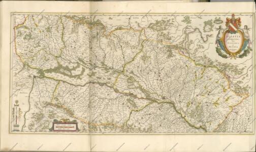
Alsatia Landgraviatus, cum Suntgoia et Brisgoia [Karte], in: Novus Atlas, das ist, Weltbeschreibung, Bd. 1, S. 260.
1 Karte aus Atlas Blaeu, Joan Blaeu, Willem Janszoon
Alsatia Landraviatus, cum Suntgoia et Brisgoia [Karte], in: Theatrum orbis terrarum, sive, Atlas novus, Bd. 1, S. 286.
1 Karte aus Atlas Blaeu, Joan Blaeu, Willem Janszoon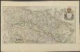
ALSATIA | Landgraviatus, | cum | SVNTGOIA | et | BRISGOIA
Ger. Mercatore | Auctore. Guiljelm. Blaeu excudit.
Alsatia Landgraviatus, cum Suntgoia et Brisgoia [Karte], in: Le théâtre du monde, ou, Nouvel atlas contenant les chartes et descriptions de tous les païs de la terre, Bd. 1, S. 291.
1 Karte aus Atlas Blaeu, Willem Janszoon und Blaeu, Joan Blaeu, Willem Janszoon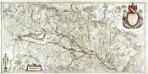
Alsatia landgraviatus, cum Svntgoia et Brisgoia
1 Karte auf 2 Blättern : Kupferdruck ; 38 x 79 cm Blaeu; Mercator Guiljelm. Blaeu excudit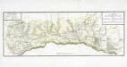
Carte des grandes routes et principales comunications de la province d'Alsace
1 Karte auf 2 Blättern : Kupferdruck ; 27 x 75 cm Weis s.n.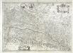
Vtriusquæ Alsatiæ superioris ac inferioris nova tabvla
1 Karte : Kupferdruck ; 37 x 53 cm Janssonius sumptibus Ioannis Ianssonii
Landgraviatus Alsatiae superioris et inferioris novissima tabula
1 : 370000 1 Karte : Kupferdruck ; 52 x 47 cm Danckerts, Justus [Danckerts]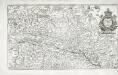
Alsatia landgrauiatus cum Svntgoia et Brisgoia
1 Karte : Kupferdruck ; 22 x 38 cm Merian Merian
[Elsass]
1 Karte auf 3 Blättern : Kupferdruck ; 36 x 113 cm Specklin s.n.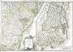
L'Alsace
1 Karte in 2 Teilen auf 1 Blatt : Kupferdruck ; Gesamtgrösse 47 x 68 cm Robert de Vaugondy; Haussard s.n.
Carte des départemens du Haut et Bas-Rhin
1 Karte : Kupferdruck ; 64 x 44 cm Basset; Buffa; Fontaine; Basset chez Basset rue St. Jacques au coin de celle des Mathurins, chez Baltazar Buffa, chez Jacques Fontaine fils
Superioris atque inferioris Alsatiæ tabula perquam accurata et exacta
1 Karte : Kupferdruck ; 55 x 48 cm Schenk Pieter Schenk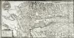
Alsatiæ svperioris et inferioris accuratissima geographica descriptio
1 Karte auf 3 Blättern : Kupferdruck ; 43 x 156 cm Meyer s.n.
Alsatia landgraviatus
1 Karte : Kupferdruck ; 57 x 48 xm Seutter Matthäus Seutter
Carte de la Haute et Basse Alsace Suntgaw, Brisgaw, Ortenaw et partie des marquisats de Baden
1 Karte auf 3 Blättern : Kupferdruck ; 90 x 34 cm Dulssecker; Fridrich chez I: R: Doulseker
Landgraviatus Alsatiae tam superioris quam inferi[oris]
1 Karte : Kupferdruck ; 57 x 47 cm Homann Johann Baptist Homann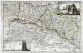
Topographia Alsatiæ, Svngoiæ, et Brisgoiæ
1 Karte : Kupferdruck ; 23 x 36 cm Bodenehr Johann Georg Bodenehr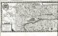
Alsatiae svperioris et inferioris accuratissima geographica descriptio
1 Karte auf 2 Blättern : Kupferdruck ; 34 x 119 cm Sandrart; Meyer Jakob von Sandrart
Superioris atque inferioris Alsatiæ tabula perquam accurata et iucunde huic insertis, annexisque
1 Karte : Kupferdruck ; 54 x 47 cm Lotter Tobias Konrad Lotter
Superioris atque Inferiores Alsatiae tabula perquam accurata et exacta, proximis regionib. jucunde huic insertis, annexisque
1 : 400000 ex conatibus P. Schenk [Amsterdam] : P. Schenk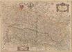
Utriusquae Alsatiae Superioris Ac Inferioris Nova Tabula. [Karte], in: Novus atlas absolutissimus, Bd. 2, S. 195.
1 Karte aus Atlas Janssonius Offizin
Landgraviatus Alsatiae tam superioris quam infer[ioris]
1 Karte : Kupferdruck ; 41 x 34 cm s.n.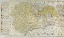
La province d'Alsace
1 Karte auf 2 Blättern : Kupferdruck ; 42 x 126 cm Mayr; Winckellmann Johann Mayr, sumptibus Lud: de Winckellmann
L'Alsace
1 Karte : Kupferdruck ; 63 x 44 cm Sanson; Basset; Cordier; Simonneau; Basset chés Basset rue St. Jacques au coin de celle des Mathurins à l'image S.te Genevieve
L'Alsace
1 Karte : Kupferdruck ; 63 x 44 cm Jaillot; Sanson; Cordier; Simonneau chez le Sr. Iaillot geographe de Sa Majesté joignant les grands Augustins aux deux globes
Gouvernement d'Alsace
1 Karte : Kupferdruck ; 35 x 24 cm, Bildgrösse 42 x 32 cm Desnos chez le Sr. Desnos ing. géograp. et libraire de Sa Majesté le roi de Danemark rue St. Jacques no. 254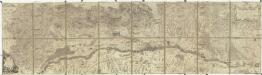
Le cours du Rhin de Bale a hert pres Philipsbourg en 5 feuilles
1 : 85000 Alsasko (Francie) Le Rouge Clermont Le Rouge