Maps of Bayern

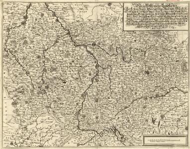
Neue Vollkomene Landkarten. Des Röm: Reichs Ober und Nider Rheinisch-Fränkisch-Schwäbisch- und theils Bayrischen Kraises, samt denenselber etc angelegner Orten an einem Und dann Anderntheils, derer dem Röm: Reich, durch Franckreich in dem vergangen und noch laufenden Seculo entzogenen Ländern, Elsaß, Lothring, Burgund, Metz, Toul, Verdün
Mollova mapová sbírka
Neue vollkomene Landkarten des h. Röm. Reichs, Ober und Nieder Rheinisch- Fränkisch- Schwäbisch- und theils Bayrischen Kraises, samt denenselber angelegner Orten, an einem und dann Anderntheils, derer dem röm. Reich, durch Franckreich in dem vergangen und noch lauffenden Seculo entzogenen Ländern, Elsaß, Lothring, Burgund, Metz, Toul, Verdun, nicht weniger denen neu gemachten dependentien mit Anmerkung aller vornehmer Ort und Vöstungen, vornemlich am Rhein-Strom, von Basell, bis unterhalb Cölln etc. etc
1 : 1100000 Alsasko (Francie) Endter, Martin Martin Endter
The South West Part of Germany
1 : 2400000 Mollova mapová sbírka Moll, Herman Moll, Hermann
SW pt. of Germany.
1 : 2300000 Bowen, Emanuel
Allemagne du Sud.
1 : 1550000 Migeon, J.
[Das Deutsches Reich, Blatt 3]
Adolf Stieler's Handatlas über alle Theile der Erde und über das Weltgebäude Stieler, Adolf Justus Perthes
Plan qui réuni les duchés de Julier, et de Berg, le palatinat du Rhin, les duchés de Baviere et de Neubourg, sans y comprendre le marquisat de Berg op Zoom
1 : 1250000 par son très humble, très soumis, et très obeisant serviteur De St. Michel, Ingenieur A Augsbourg : publié par les freres Lotter
Süddeutchland

Süddeutschland

Totius Rheni ab ejus capitibus ad Oceanum usque Germanicum in quem se exonerat Novißima Descriptio
1 : 810000 Mollova mapová sbírka Janssonius, Johannes Janssonius, Johannes I
Germany - South. Pergamon World Atlas.
1 : 1250000 Polish Army Topography Service
Het oorlogstooneel van 1796 in Duitschland
1 : 1850000 Annotatie: Kaart IV in: Prins Frederik der Nederlanden en zijn tijd / F. de Bas. - Dl. 1; Annotatie geografische gegevens: Inzetkrt: Het slagveld van Würzburg op 3 september. - 1:740.000 Schiedam : H.A.M. Roelants
Westdeutsches Mittelgebirge
Plastischer Schul-Atlas über alle Theile der Erde : in 24 Karten Woldermann, G Verlag von P. Eckerlein
Germany.
1 : 1500000 Colton, G.W.
Empire of Germany (southern portion).
1 : 1050000 Johnston, Alexander Keith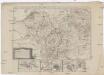
Neue Karte von den gegenwärtigen Französischen Kriegs - Schauplatze, welche die Länder am Ober und nieder Rhein, Elßas, Lothringen, die Nieder-Pfaltz, Maynz, Trier, Cöln, dei Österreichische Niederlandes, ein Theil von Frankreich, Westphalen, Heßsen und Schwaben etc
1 : 1400000 Alsasko (Francie)
Plan qui réüni les duchés de Julier, et de Berg, le palatinat du Rhin, les duchés de Baviere et de Neubourg
1 Karte : Kupferdruck ; 44 x 56 cm Saint Michel; Lotter; Lotter publié par les freres Lotter
Accurate Land Charte des Rheins Mossel und Neckar-Stroms
1 : 845700 Mosela, řeka-oblast Christoph Riegel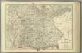
Empire of Germany (southern portion).
1 : 1050000 Johnston, Alexander Keith
Blatt 97: Metzingen, uit: Topographische Karte von Württemberg im Massstab 1:25.000 / hrsg. vom Statistischen Landesamt
1 : 25000 titelvariant: Topographische Karte des Königreichs Württemberg im Massstabe 1:25.000; Annotatie: Titelvariant: Topographische Karte des Königreichs Württemberg im Massstabe 1:25.000; Incompleet (4 bl. aanwezig) Württembergisches Statistisches Landesamt [Stuttgart : Statistisches Landesamt]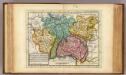
The south west part of Germany.
1 : 2400000 Moll, Herman, d. 1732
Land Charte zum Schau Platz des Kriegs der Röm Kaiserl Maje und dero hohen Alliirten am Rhein
1 : 840000 Mollova mapová sbírka Riegel, Christoph Riegel, Christoph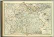
Empire of Germany (southern portion).
1 : 1050000 Johnston, W. & A.K.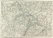
Carte Generale d'Allemagne
1 : 1300000 Mollova mapová sbírka Eisenschmidt, Johann Caspar Julien, Roch Joseph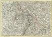
Mappa Geographica summo labore, accurate et novissime exarata, exhibens Circulos aliquot Germaniae, praesertim illos ubi Bellum nunc Geritur
1 : 1300000 Mollova mapová sbírka Lotter, Tobias Conrad Lotter, Tobias Conrad
Süddeutschland
Volksschul-Atlas über alle Teile der Erde Lange, Henry Druck und Verlag von Georg Westermann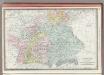
Germany Southern Portion.
1 : 1430000 Rand McNally and Company
Landskarte zum Schauplatz des Kriegs der Röm. Kaisers. Maje. und dero hohen alliirten am Rhein
1 : 840000 Německo Christoph Kriegel
Höhen Charte oder bildlich vergleichende Uebersicht der bedeutendesten Berge in Deutschland und der Schweiz
1 : 22000 Německo Weiland, Karl Ferdinand Geograph. Institut