Maps of Belgium
Les Provinces des Pays-Bas Catholiques ou a Most Exact Map of Flanders or Austrian Netherlands &c.
1 : 440000 Mollova mapová sbírka Moll, Herman Bowles, I.
BELGII VETERIS TYPUS
1 : 1400000 Belgie Ortelius, Abraham Hondius, Henricus C.I. Visscher excudebat
Belgii veteris typvs
Belgie Ortelius, Abraham Abraham Ortelius
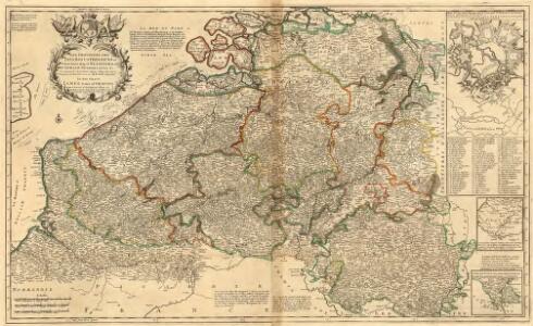
Les Provinces des Pays-Bas Catholiques Vulgairement Connües Sous le Nom de Flandre
1 : 800000 Mollova mapová sbírka Sanson, Nicolas Michault, René
Carte Particuliere des Duchéz de Brabant et de Limbourg
1 : 317000 Mollova mapová sbírka Baillieul, Gaspard Bailleul, Gaspard
NOVA XVII PROVINCIARVM Germaniae Inferioris tabula, Leonis effigie, accurate delineata
1 : 100000 Belgie Visscher, Claes Jansz. bij Claes Ianß Visscher
Carte des Paysbas Catholiques
1 : 700000 Mollova mapová sbírka Delisle, Guillaume L'Isle, Guillaume de
Carte de la France, no. 1
1 Blatt : 60 x 92 cm s.n.
Algemeene kaart der Vereenigde Nederlanden : getrokken uyt de aller naauwkeurigsten kaarten, opde plaatsen selve gemaakt, en geschikt volgens de beste en nieuwste waarnemingen en aanteekeningen.
1 : 1000000 Zacharias Châtelain t' Amsterdam : by Zacharias Châtelain
Circulus Burgundicus, integer secundum fines antiquos, qui fuerunt aetate Maximil. I.
1 : 2600000 Mollova mapová sbírka Franz, Johann Michael Homann, Johann Baptista - dědici

Carte historique de la Belgique au moyen age / par Louis Delgeur
1 : 1135400 Delgeur, Louis [Bruxelles : Vandermaelen]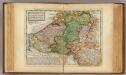
Flanders or the Austrian Netherlands.
1 : 1400000 Moll, Herman, d. 1732
The theatre of the present war in the Netherlands : being an improvement of a large map of the Low Countries by Mr. La Rouge : with the addition of the adjacent parts of England, Germany and the United Provinces
1 : 350000 Annotatie: Met plaatsnamenregister (met coördinaten en afstanden t.o.v. Londen, Parijs en Den Haag) London : printed for R. Wilkinson ... and Bowles & Carver
Bez titulu: soubor map pag. 97

Provinciae Belgii regii
1 : 760000 Belgie Danckerts, Justus Iusto Danckerts
PROVINCIAE BELGII REGII
1 : 760000 Belgie Danckerts, Justus Iusto Danckerts
Les XVII provinces du Pais-Bas
1 : 264000 Belgie Aa, Pieter van der George P. van der Aa
Austrian French and Dutch Netherlands.
1 : 1030000 Carey, Mathew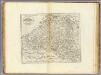
Austrian French and Dutch Netherlands.
1 : 1020000 Carey, Mathew
Austrian French and Dutch Netherlands.
1 : 1020000 Carey, Mathew
Les Provinces des Pays-Bas Catholiques [...] [Karte], in: Atlas nouveau, contenant toutes les parties du monde [...], Bd. 2, S. 20.
1 Karte aus Atlas Sanson, Nicolas Jaillot, Alexis Hubert und Mortier, Pieter
Nieuwe en naukeurige kaart der tien catholijke Nederlanden, uit de beste autheuren en beroemste heedendaagsche kaarten opgemaakt, en volgens sterekundige waarnemingen in orde gebragt
1 : 850000 door Eman. Bowen verb. door W.A. Bachiene ; J. v. Jagen fecit, 1775 [Amsterdam] : [Matthijs Schalekamp]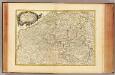
Pays Bas meridionale.
1 : 970000 Janvier, Jean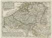
Flanders or the Austrian Netherlands
1 : 1400000 Mollova mapová sbírka Moll, Herman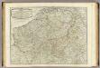
The Catholic Netherlands.
1 : 630000 Kitchin, Thomas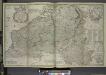
Les provinces des pays-bas Catholiques, ou a most exact map of Flanders or Austrian Netherlands &c.
from The world described, or, A new and correct sett of maps : shewing the kingdoms and states in all the known parts of the earth, with the principal cities, and most considerable towns in the world ... / ... by Herman Moll, geographer ...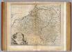
Netherlands or Low Countries.
1 : 980000 Bowen, Emanuel
Les provinces apellées Pais-Bas, connues sous les noms de Flandre et de Hollande, divisée suivant quelles sont possedées aujourdhuy par les Roys de France et d'Espange et les Etats-Géneraux des Provinces Unies
1 : 800000 par N. de Fer... P. Starckman sculp. A Paris : se vend chez Danet ...