Maps of Netherlands

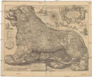
NOVA XVII PROVINCIARVM Germaniae Inferioris tabula, Leonis effigie, accurate delineata
1 : 100000 Belgie Visscher, Claes Jansz. bij Claes Ianß Visscher
De groote Nederlandse stedenwyzer, vertoonende met een opslag des oogs, de afgelegentheden tussen 108 steden der XVII. provintien, of Beantwoording op 5786 vragen, hoe veel uuren gaans de eene plaats van den ander is gelegen = La grande echelle des Pais-Bas, qui montre du premier coup d’oeil, la distence de 108 villes, des XVII. provinces, ou Reponce sur 5786. demandes, pour savoir de quelle distence une ville est eloignée de l’autre
te samen gesteld en int ligt gegeeven door Jan de Lat kaart en boekverkoper tot Deventer. Deventer : Jan de Lat
Novissima, et accuratissima leonis Belgici, seu septemdecim regionum descriptio
1 : 1200000 Antverpy (Belgie) Visscher, Claes Jansz. by Claes Iansz. Visscher
Bez titulu: soubor map pag. 97

Belgium & Holland.
1 : 1000000 John Bartholomew and Son
Novissima et accuratissima XVII provinciarum Germaniae inferioris tabula
1 : 800000 1 Karte : Kupferdruck ; 47 x 54 cm Danckerts, Justus [Danckerts]
Die Niederlande und Belgien
1 : 830000 Belgie Kiepert, Heinrich Eulenstein, F. Geographisches Institut
[89][89] Novissima et accuratissima XVII Provinciarum Germaniae Inferioris tabula, uit: Atlas sive Descriptio terrarum orbis
Annotatie: Gedigitaliseerde versie. Amsterdam. Heiloo : Picturae (vervaardiger), 2015. tiff-bestand. Gedigitaliseerd: 07-01-2015; Origineel: Universiteitsbibliotheek Vrije Universiteit (XL.05127.-) ; Netherlands; Titelpagina ontbreekt Wit, Frederik de Amsterdam : Frederick de Wit
Les provinces apellées Pais-Bas, connues sous les noms de Flandre et de Hollande, divisée suivant quelles sont possedées aujourdhuy par les Roys de France et d'Espange et les Etats-Géneraux des Provinces Unies
1 : 800000 par N. de Fer... P. Starckman sculp. A Paris : se vend chez Danet ...
Algemeene kaart der Vereenigde Nederlanden : getrokken uyt de aller naauwkeurigsten kaarten, opde plaatsen selve gemaakt, en geschikt volgens de beste en nieuwste waarnemingen en aanteekeningen.
1 : 1000000 Zacharias Châtelain t' Amsterdam : by Zacharias Châtelain
Belgii universi seu inferioris Germaniae quam XVII. provinciae, Austriaco, Gallico et Batavo sceptro parentes constituunt, nova tabula geographica
1 : 1050000 Belgie Mayer, Tobias Cassini de Thury cura et studio Homannianorum Heredum
Belgii universi seu inferioris Germaniae quam XVII. provinciae, Austriaco, Gallico et Batavo sceptro parentes constituunt, nova tabula geographica
1 : 1050000 Belgie Mayer, Tobias Cassini de Thury cura et studio Homannianorum Heredum
BELGII UNIVERSI seu INFERIORIS GERMANIAE quam XVII PROVINCIAE, Austriaco, Gallico et Batavo Sceptro parentes constituunt, nova Tabula Geographica
1 : 1100000 Belgie Mayer, Tobias Cassini de Thury cura et studio Homannianorum Heredum
Belgii universi seu inferioris Germaniae quam XVII provinciae Austriaco, Gallico et Batavo sceptro parentes constituunt nova tabula geographica
1 : 1050000 Belgie Mayer, Tobias Cassini de Thury cura et studio Homannianorum Heredum
Novissima et accuratissima XVII provinciarum Germaniae Inferioris delineatio
1 : 910000 A. Deur sculpsit. [Amsterdam] : ex officina Nicolai Visscher
Postkarte von dem Vereinigten Niederlanden
Belgie Stenger, Johann im von Reillyschen Landkarten und Kunstwerke Verschleiss Komptoir
Nieuwe en nauwkeurige kaart der XVII Provincien van Nederland
1 : 1800000 Amsterdam : by Isaak Tirion
Novissima et accuratissima XVII provinciarum Germaniae inferioris delineatio
1 : 897000 Belgie Visscher, Nicolaes Jansz. ex officina Nicolai Visscher
Novissima et accuratissima XVII Provinciarum Germaniae Inferioris Delineatio. [Karte], in: Novus atlas absolutissimus, Bd. 3, S. 22.
1 Karte aus Atlas Janssonius Offizin
Novissima et accuratissima XVII provinciarum Germaniae inferioris tabula
1 : 897000 Belgie Wit, Frederick de Munter, Johann ex officina Reineri & Josuae Ottens
Les Pays Bas.
1 : 2150000 Lattre, Jean
Mare Germanicum ab Amelandia ad promontoria Caleti et Doveræ
1 Karte : Kupferdruck ; 47 x 57 cm Renard by L. Renard
Tableau des XVII Provinces des Pays Bas
Mollova mapová sbírka Husson, Pieter Husson, Pierre
Tafel Van de XVII Nederlandze Provincien
Mollova mapová sbírka Specht, Caspar
Netherlands.
1 : 1950000 Lavoisne, M.
Germaniae Inferioris XVII Provinciarum accuratissima tabula
1 : 940000 nuperrime edita per Nicolaum Visscher. [Amsterdam] : nunc apud Petrum Schenk Jun.
Hollanda
[Giralomo Porro] [Venetië] : Simon Galignani ; Giralomo Porro]
Circulus Burgundicus, integer secundum fines antiquos, qui fuerunt aetate Maximil. I.
1 : 2600000 Mollova mapová sbírka Franz, Johann Michael Homann, Johann Baptista - dědici