Maps of Szerencsi járás

Szikszo und Tisza-Dob.
from Spezialkarte der osterreichisch-ungarischen Monarchie.
Saros-Nagypatak und Satoralja-Ujhely.
from Spezialkarte der osterreichisch-ungarischen Monarchie.
Goncz und Csobad (Ungarn).
from Spezialkarte der osterreichisch-ungarischen Monarchie.
Szikszó u.Tisza-Dob
1 : 75000 Maďarsko Pflügl K. u. k. Militärgeographisches Institut
Tokaj
1 : 75000 Maďarsko Palitschek, Rudolf K. u. k. Militärgeographisches Institut
Tokai.; Spezialkarte der osterreichisch-ungarischen Monarchie.
from Spezialkarte der osterreichisch-ungarischen Monarchie. Austro-Hungarian Monarchy. Militärgeographisches Institut.,
Tokaj
1 : 75000 Maďarsko Vojenský zeměpisný ústav
A bodrogkereszturi csata vazlata (1849 april 22- és 23-án)
Ungarn Bodrogkeresztúr Schlacht Ungarn / Revolution <1848-1849>
III. vojenské mapování 4667/4
1 : 25000
Slov. Nové Mesto a okolí
1 : 75000 Vojenský zeměpisný ústav
III. vojenské mapování 4667
1 : 75000
III. vojenské mapování 4666
1 : 75000
Gönc und Csobád
1 : 75000 Maďarsko Udalrik, A. K. u. k. Militärgeographisches Institut
Čejkov a Sárosnagypatak
1 : 75000 Maďarsko Vojenský zeměpisný ústav
Ružový Dvor
1 : 75000 Maďarsko Vojenský zeměpisný ústav
Genc a Csobád
1 : 75000 Maďarsko Kartografické odd. při Min. nár. obrany
Sáros-Nagypatak und Sátoralja-Ujhely
1 : 75000 Maďarsko Bernhauer K. u. k. Militärgeographisches Institut
[Gradkartenblatt]
1 : 25000 Slovensko Vojenský zeměpisný ústav
III. vojenské mapování 4668/3
1 : 25000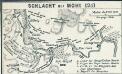
Schlacht bei Mohi 1241
1 : 185000 Muhi Muhi / Schlacht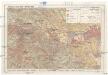
Miskolc - Lillafüred - Tapolcafürdo
1 : 50000 M. Kir. Állami Térképészet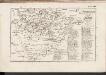
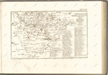
C. Zempliniensis. Tab. II
Slowakei Komitat Zemplín
Miskolcz 136, uit: Special-Karte von Mittel-Europa / nach amtlichen Quellen bearbeitet von W. Liebenow
1 : 300000 titelvariant: W. Liebenow's Mittel-Europa; Annotatie: Titel boven de bladen: W. Liebenow's Mittel-Europa Johannes Wilhelm Liebenow 1822-1897 Frankfurt a. M. : Ludwig Ravenstein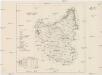
Szabolcser Comitat
1 : 280000 Szabolcs-Szatmár-Bereg (Maďarsko)
Szabolcser Comitat
1 : 280000 Szabolcs-Szatmár-Bereg (Maďarsko)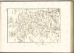

Stolice Abauj-Torna a Boršod
Abaúj-Torna, Komitat Borsod, ethnische Gruppe
C. Abaujvár
Slowakei Ungarn Abaúj-Torna