Maps of District of Košice - okolie

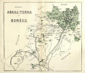
Stolice Abauj-Torna a Boršod
Abaúj-Torna, Komitat Borsod, ethnische Gruppe

C. Abaujvár
Slowakei Ungarn Abaúj-Torna
Abauj-Torna vármegye térképe
1 : 380000 Košice (Slovensko : oblast) Kogutowicz, Manó Magyar Földrajzi Intézet
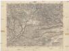
Kaschau (Ungarn). Small #9918
from Spezialkarte der osterreichisch-ungarischen Monarchie.
C. Tornensis
Ungarn Komitat Torna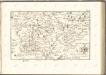

Borsod vármegye
1 : 410000 Görög, Demeter Biller, Bernhard Görög
Kassa (Kaschau) (Ungarn). #9916
from Spezialkarte der osterreichisch-ungarischen Monarchie.
Rosenau und Szilas.
from Spezialkarte der osterreichisch-ungarischen Monarchie.
Szendro und Putnok (Ungarn).
from Spezialkarte der osterreichisch-ungarischen Monarchie.
Goncz und Csobad (Ungarn).
from Spezialkarte der osterreichisch-ungarischen Monarchie.
Umgebungs - Karte von Kaschau

Bretka
1 : 75000 Maďarsko Vojenský zeměpisný ústav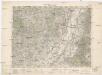
Ružový Dvor
1 : 75000 Maďarsko Vojenský zeměpisný ústav
Genc a Csobád
1 : 75000 Maďarsko Kartografické odd. při Min. nár. obrany
III. vojenské mapování 4566
1 : 75000
III. vojenské mapování 4565
1 : 75000
III. vojenské mapování 4665
1 : 75000
Košice
1 : 75000 Košice-oblast (Slovensko) Vojenský zeměpisný ústav
Košice
1 : 75000 Košice (Slovensko : oblast) Vojenský zeměpisný ústav
Košice
1 : 75000 Košice (Slovensko : oblast) Vojenský zeměpisný ústav
Košice
1 : 75000 Košice (Slovensko : oblast) Vojenský zeměpisný ústav
Rosenau und Szilas
1 : 75000 Rožňava, Umland Geripp: Führ. Karger. Terrain: Hauptm. A. Pitron
III. vojenské mapování 4666
1 : 75000
Slovenský Kras

Kaschau
1 : 75000 Košice, Umland Geripp: Assistent Pflügl. Terrain: Führer Kotrtsch
Szendrő
1 : 75000 Szendrő, Szendrő (Region)
Kaschau (Ungarn). 9917; Spezialkarte der osterreichisch-ungarischen Monarchie.
from Spezialkarte der osterreichisch-ungarischen Monarchie. Austro-Hungarian Monarchy. Militärgeographisches Institut.,
Rožňava
1 : 75000 Maďarsko Vojenský zeměpisný ústav
Rožňava
1 : 75000 Maďarsko Vojenský zeměpisný ústav
Rožňava
1 : 75000 Maďarsko Vojenský zeměpisný ústav