Maps of District of Rožňava

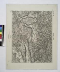
Rosenau und Szilas.
from Spezialkarte der osterreichisch-ungarischen Monarchie.
III. vojenské mapování 4565
1 : 75000
Rosenau und Szilas
1 : 75000 Rožňava, Umland Geripp: Führ. Karger. Terrain: Hauptm. A. Pitron
Slovenský Kras

Rožňava
1 : 75000 Maďarsko Vojenský zeměpisný ústav
Rožňava
1 : 75000 Maďarsko Vojenský zeměpisný ústav
Rožňava
1 : 75000 Maďarsko Vojenský zeměpisný ústav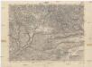
Rožňava
1 : 75000 Maďarsko Vojenský zeměpisný ústav
[Mapový list]
1 : 25000 Slovensko Vojenský zeměpisný ústav
[Mapový list]
1 : 25000 Rožňava-oblast (Slovensko) Vojenský zeměpisný ústav
[Mapový list]
1 : 25000 Slovensko Vojenský zeměpisný ústav
III. vojenské mapování 4565/3
1 : 25000
III. vojenské mapování 4565/2
1 : 25000
[Mapový list]
1 : 25000 Slovensko Vojenský zeměpisný ústav
III. vojenské mapování 4565/4
1 : 25000
III. vojenské mapování 4565/1
1 : 25000
III. vojenské mapování 4566/1
1 : 25000
Gömörpanyit helysége határának Terképe

III. vojenské mapování 4665/1
1 : 25000
[Mapový list]
1 : 25000 Slovensko Vojenský zeměpisný ústav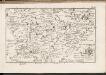
C. Tornensis
Ungarn Komitat Torna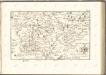

Iglo und Mereny.
from Spezialkarte der osterreichisch-ungarischen Monarchie.
Kaschau (Ungarn). Small #9918
from Spezialkarte der osterreichisch-ungarischen Monarchie.
Szendro und Putnok (Ungarn).
from Spezialkarte der osterreichisch-ungarischen Monarchie.
Kassa (Kaschau) (Ungarn). #9916
from Spezialkarte der osterreichisch-ungarischen Monarchie.
Nagy-Rocze und Rimm-Banya (Ungarn).
from Spezialkarte der osterreichisch-ungarischen Monarchie.
Slovenský raj

Bretka
1 : 75000 Maďarsko Vojenský zeměpisný ústav