Maps of District of Košice - okolie

C. Abaujvár
Slowakei Ungarn Abaúj-Torna

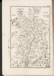
Abauj-Torna vármegye térképe
1 : 380000 Košice (Slovensko : oblast) Kogutowicz, Manó Magyar Földrajzi Intézet
Kaschau (Ungarn). Small #9918
from Spezialkarte der osterreichisch-ungarischen Monarchie.
Kassa (Kaschau) (Ungarn). #9916
from Spezialkarte der osterreichisch-ungarischen Monarchie.
Goncz und Csobad (Ungarn).
from Spezialkarte der osterreichisch-ungarischen Monarchie.
Umgebungs - Karte von Kaschau

Gelnica a okolie
Ružový Dvor
1 : 75000 Maďarsko Vojenský zeměpisný ústav
Genc a Csobád
1 : 75000 Maďarsko Kartografické odd. při Min. nár. obrany
III. vojenské mapování 4566
1 : 75000
Košice
1 : 75000 Košice-oblast (Slovensko) Vojenský zeměpisný ústav
Košice
1 : 75000 Košice (Slovensko : oblast) Vojenský zeměpisný ústav
Košice
1 : 75000 Košice (Slovensko : oblast) Vojenský zeměpisný ústav
Košice
1 : 75000 Košice (Slovensko : oblast) Vojenský zeměpisný ústav
III. vojenské mapování 4666
1 : 75000
Kaschau
1 : 75000 Košice, Umland Geripp: Assistent Pflügl. Terrain: Führer Kotrtsch
Kaschau (Ungarn). 9917; Spezialkarte der osterreichisch-ungarischen Monarchie.
from Spezialkarte der osterreichisch-ungarischen Monarchie. Austro-Hungarian Monarchy. Militärgeographisches Institut.,
Slanské pohorie

Gönc und Csobád
1 : 75000 Maďarsko Udalrik, A. K. u. k. Militärgeographisches Institut
Eperjes und Gölniczbánya
1 : 75000 Prešov, Umland Geripp: Assist. Leitner u. Offizl. Kostrba. Terrain: Oblt. Jonak E. v. Freyenwald u. Aspt. Haag
Eperjes und Golniczbanya.; Spezialkarte der osterreichisch-ungarischen Monarchie.
from Spezialkarte der osterreichisch-ungarischen Monarchie. Austro-Hungarian Monarchy. Militärgeographisches Institut.,
Gelnica
1 : 75000 Slovensko Vojenský zeměpisný ústav
Gelnica
1 : 75000 Slovensko Vojenský zeměpisný ústav
Gelnica
1 : 75000 Slovensko Vojenský zeměpisný ústav
Prešov a Gelnica
1 : 75000 Prešov (Slovensko : oblast) Kartografické odd. při Min. Nár. Obrany
III. vojenské mapování 4566/1
1 : 25000
Toketerebes und Nagyszalancz.
from Spezialkarte der osterreichisch-ungarischen Monarchie.
Saros-Nagypatak und Satoralja-Ujhely.
from Spezialkarte der osterreichisch-ungarischen Monarchie.