Maps of Gönci járás
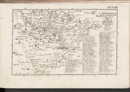
C. Zempliniensis. Tab. II
Slowakei Komitat Zemplín
Miskolcz 136, uit: Special-Karte von Mittel-Europa / nach amtlichen Quellen bearbeitet von W. Liebenow
1 : 300000 titelvariant: W. Liebenow's Mittel-Europa; Annotatie: Titel boven de bladen: W. Liebenow's Mittel-Europa Johannes Wilhelm Liebenow 1822-1897 Frankfurt a. M. : Ludwig Ravenstein
Szabolcser Comitat
1 : 280000 Szabolcs-Szatmár-Bereg (Maďarsko)
Szabolcser Comitat
1 : 280000 Szabolcs-Szatmár-Bereg (Maďarsko)

Abauj-Torna vármegye térképe
1 : 380000 Košice (Slovensko : oblast) Kogutowicz, Manó Magyar Földrajzi Intézet
Szikszo und Tisza-Dob.
from Spezialkarte der osterreichisch-ungarischen Monarchie.
Saros-Nagypatak und Satoralja-Ujhely.
from Spezialkarte der osterreichisch-ungarischen Monarchie.
Goncz und Csobad (Ungarn).
from Spezialkarte der osterreichisch-ungarischen Monarchie.
Kis-Varda und Vasaros-Nameny.
from Spezialkarte der osterreichisch-ungarischen Monarchie.
III. vojenské mapování 4667
1 : 75000
Slov. Nové Mesto a okolí
1 : 75000 Vojenský zeměpisný ústav
Sáros-Nagypatak und Sátoralja-Ujhely
1 : 75000 Maďarsko Bernhauer K. u. k. Militärgeographisches Institut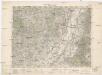
Ružový Dvor
1 : 75000 Maďarsko Vojenský zeměpisný ústav
Genc a Csobád
1 : 75000 Maďarsko Kartografické odd. při Min. nár. obrany
Szikszó u.Tisza-Dob
1 : 75000 Maďarsko Pflügl K. u. k. Militärgeographisches Institut
Čejkov a Sárosnagypatak
1 : 75000 Maďarsko Vojenský zeměpisný ústav
Tokaj
1 : 75000 Maďarsko Palitschek, Rudolf K. u. k. Militärgeographisches Institut
Kis-Várda und Vásáros-Namény
1 : 75000 Kisvárda, Vásárosnamény Geripp: Feldw. Rücker. Terrain: Oberlt. Schlichting
Čop a Mándok
1 : 75000 Maďarsko Vojenský zeměpisný ústav
Čop a Mándok
1 : 75000 Maďarsko Vojenský zeměpisný ústav
Mándok
1 : 75000 Szabolcs-Szatmár-Bereg
III. vojenské mapování 4668
1 : 75000
III. vojenské mapování 4666
1 : 75000
Tokai.; Spezialkarte der osterreichisch-ungarischen Monarchie.
from Spezialkarte der osterreichisch-ungarischen Monarchie. Austro-Hungarian Monarchy. Militärgeographisches Institut.,
Mandok und Csap (Ungarn).; Spezialkarte der osterreichisch-ungarischen Monarchie.
from Spezialkarte der osterreichisch-ungarischen Monarchie. Austro-Hungarian Monarchy. Militärgeographisches Institut.,
Tokaj
1 : 75000 Maďarsko Vojenský zeměpisný ústav
Mándok und Csap
1 : 75000 Maďarsko Charlemont K. u. k. Militärgeographisches Institut
Gönc und Csobád
1 : 75000 Maďarsko Udalrik, A. K. u. k. Militärgeographisches Institut