Maps of England

Road map of Great Britain
1 : 633600 Birmingham (Anglie) Ordnance Survey Office
A new and accurate map of all the direct & principal cross roads in England and Wales
Anglie
Reisekarte von England
Restricted Flying Areas and Balloon Areas, Air Ministry, GSGS Misc 501
Great Britain War Office General Staff Geographical Section Great Britain Ministry of Defence Survey Production Centre
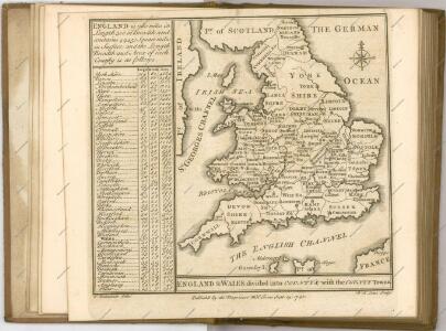
An accurate map of England and Wales with the principal roads from the best authorities
1 : 1
Carte de l'Angleterre au tems de la decente des romains
1 Karte : Kupferdruck ; 24 x 22 cm s.n.
Airfields, UK
Great Britain. War Office. General Staff. Geographical Section
Le Royaume d'Angleterre , divisé selon les sept Royaumes, ou Heptarchie des Saxons, avec la Principauté de Galles, et subdivisé en shires ou comtés
1 : 1400000
Grossbritannien. Sudliches Blatt: England U. Wales.
1 : 1500000 Petermann, A.
[Grossbritannien, Südliches Blatt]
Hand-Atlas über alle Theile der Erde und über das Weltgebäude Stieler, Adolf Justus Perthes
England.
1 : 1050000 Thomson, John
England.
1 : 1774080 Mitchell, Samuel Augustus
Grossbritannien Südlicher Theil
Adolf Stieler's Handatlas über alle Theile der Erde und über das Weltgebäude Stieler, Adolf Justus Perthes
[Grossbritannien, Südliches Blatt]
Handatlas über alle Theile der Erde und über das Weltgebäude Stieler, Adolf Justus Perthes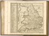

A new mapp of the kingdome of England
Anglie Overton, John by Nicolas Visscher
England, Wales, Scotland.
1 : 1020000 Faden, William, 1750?-1836
The Inland Navigation, Rail Roads, Geology and Minerals of England & Wales.
1 : 1090000 Arrowsmith, John
Geological map England, Wales.
1 : 1774080 Letts, Son & Co.
Railway, statistical England, Wales.
1 : 1774080 Letts, Son & Co.
England, Wales.
1 : 1480000 Hall, S. (Sidney)
England.
1 : 1090000 Arrowsmith, John
Ordnance survey map of XVII century England
1 : 1000000 Anglie Ordnance Survey Office
Anglie a Wales

England, Wales.
1 : 2850000 Carey, Mathew
England and Wales.
1 : 2534400 Lucas, Fielding Jr.
England, Wales.
1 : 2850000 Carey, Mathew
England, Wales (outline)
1 : 2750000 Patteson, Edward