Maps of England


An accurate map of England and Wales with the principal roads from the best authorities
1 : 1
Le Royaume d'Angleterre , divisé selon les sept Royaumes, ou Heptarchie des Saxons, avec la Principauté de Galles, et subdivisé en shires ou comtés
1 : 1400000
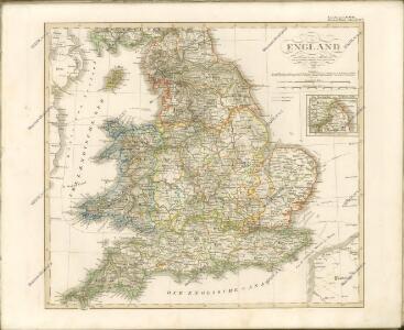
England
Stieler's Hand-Atlas Stieler, Adolf bei Justus Perthes
Reisekarte von England

England und Wales
Hand-Atlas über alle Theile der Erde nach dem neuesten Zustande und über das Weltgebäude Stieler, Adolf bei Justus Perthes
England, Ireland.
1 : 3900000 Peterson, Augusts
England & Wales.
1 : 1013760 Stanford, Edward
England
Hand-Atlas über alle Theile der Erde nach dem neuesten Zustande und über das Weltgebäude Stieler, Adolf bei Justus Perthes
The roads of ye south part of Great Britain, called England and Wales, containing all ye cities, market towns, post towns, boroughs: and whatever places have ye election of members of parliament &c. all the great or post roads, and principal cross-roads &
1 : 2000000
Geological map of England and Wales / publ. under the superintendence of the Society for the Diffusion of Useful Knowledge ; arr. by Roderick Impey Murchison ; S.P. Woodward del.; cold. by T. Malby; J. & C. Walker sculpt
1 : 1780000 Annotatie: Oorspr. uitg.: Strand : Chapman and Hall, 1843; Annotatie geografische gegevens: Met aanvullingen tot 1847 Roderick Impey Murchison 1792-1871; S.P. Woodward; T. Malby; Society for the Diffusion of Useful Knowledge London : Knight
ANGLIA REGNUM IN OMNES SUOS DUCATUS, COMITATUS ET P[ROVINCIAS DIVISUM]
1 : 2300000 Anglie Wit, Frederik de F. de Wit
Magnae Britanniae pars meridionalis in qua regnum Angliae tam in septem antiqua Anglo-Saxonum regna quam in omnes hodiernas regiones accurate divisum hic ostenditur quam tabula ab archetypo Vischeriano desumptam
1 : 1300000 Anglie Homann, Johann Baptist Ioh. Bapt. Homan[n]

A new mapp of the kingdome of England
Anglie Overton, John by Nicolas Visscher
Britanniae sive Angliae regnum
1 : 1300000 Anglie Lotter, Tobias Conrad sumtibus Tob. Conradi Lotter
[Kaart], uit: W. & A. K. Johnston's touring and motoring map of England and Wales : showing the main roads, and railways
1 : 633600 Edinburgh [etc.] : Johnston
England and Wales.
1 : 2050000 Carey, Mathew
Map of England and Wales.
1 : 2000000 Carey, Mathew
England and Wales.
1 : 1900800 Carey, Mathew
Map Of England and Wales.
1 : 1900800 Carey, Mathew
Map Of England and Wales.
1 : 1900800 Carey, Mathew
England.
1 : 1760000 Mitchell, Samuel Augustus
England.
1 : 1760000 Mitchell, Samuel Augustus
England
1 : 1380000 Anglie Weiland, Karl Ferdinand Maedel, Carl Jos. Geograph. Institut
England
1 : 1380000 Anglie Weiland, Karl Ferdinand Maedel, Carl Jos. Geograph. Institut
England And Wales.
1 : 2850000 Finley, Anthony
Composite: England & Wales.
1 : 633600 Stanford, Edward