Maps of England

Carte de l'Angleterre au tems de la decente des romains
1 Karte : Kupferdruck ; 24 x 22 cm s.n.
Carte de l'Angleterre au tems des conquétes des Romains
1 Karte : Kupferdruck ; 23 x 22 cm s.n.
MAGNAE BRITANNIAE
1 : 1340000 Anglie Homann, Johann Baptist Visscher, Nicolaes Jansz. Ioh. Bapt. Homan[n]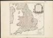
Le Royaume d'Angleterre , divisé selon les sept Royaumes, ou Heptarchie des Saxons, avec la Principauté de Galles, et subdivisé en shires ou comtés
1 : 1400000
Anglia in septem Anglo-Saxonum regna omnesque hodiernas regiones ordine distincta
1 : 1400000 ededit Petrus Schenk [Amsterdam : Petrus Schenk]
Neueste Karte von England
Grosser Hand-Atlas über alle Theile der Erde in 170 Karten Meyer, J. Verlag des Bibliographischen Instituts
Britanniae sive Angliae Regnum, tam secundum prisca Anglo-Saxonum Imperia, quam recentiorem Provinciarum divisionem accuratissime designatum
1 : 1300000 studio et sumptibus Tob. Conradi Lotter, Chalgogr. et Geogr. Augustani. [Augsburg] : [Tob. Conrad. Lotter]
An accurate map of England and Wales with the principal roads from the best authorities
1 : 1
Le royaume d'Angleterre
1 Karte : Kupferdruck ; 55 x 47 cm Le Rouge; Basset; Basset chez Basset rue St. Jacques
Le royaume d'Angleterre
1 Karte : Kupferdruck ; 55 x 47 cm Le Rouge; Basset; Basset chez Basset rue St. Jacques
Britanniæ sive Angliæ regnum
1 Karte : Kupferdruck ; 56 x 48 cm Lotter Tobias Konrad Lotter
Le royaume d'Angleterre
1 Karte : Kupferdruck ; 55 x 47 cm Le Rouge Georges Louis Le Rouge rue des Augustins
Britanniæ sive Angliæ regnum
1 Karte : Kupferdruck ; 56 x 48 cm Seutter Matthäus Seutter
Anglia Cambdeni
1 Karte : Kupferdruck ; 38 x 32 cm Camden; Weigel; Kauffer Christoph Weigel
Magnæ Britanniae pars meridionalis, in qua regnum Angliæ
1 Karte : Kupferdruck ; 55 x 47 cm Homann; Visscher Johann Baptist Homann
Nouvelle carte de l'Angleterre
1 Karte : Kupferdruck ; 45 x 47 cm, Gesamtgrösse 45 x 63 cm Châtelain s.n.
Anglia in septem anglo-saxonum regna
1 Karte : Kupferdruck ; 53 x 47 cm Schenk Pieter Schenk
A new mapp of the kingdome of England
1 Karte : Kupferdruck ; 57 x 50 cm printed and given out by Nicolas Visscher upon the Dam at the signe of the fisher, by Iohn Overton at the white horse without Newgate
A new mapp of the kingdome of England
1 Karte : Kupferdruck ; 57 x 50 cm printed and given out by Nicolas Visscher upon the Dam at the signe of the fisher, by Iohn Overton at the white horse without Newgate
Anglia regnum in omnes suos ducatus, comitatus, et provincias divisum
1 Karte : Kupferdruck ; 57 x 48 cm Wit Frederick de Wit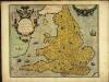
Angliæ regni florentissimi nova descriptio
1 Karte : Kupferdruck ; 38 x 45 cm Lhuyd; Ortelius s.n.
Angliæ regni florentissimi nova descriptio
1 Karte : Kupferdruck ; 38 x 45 cm Ortelius; Lhuyd s.n.
England and Wales.
1 : 1550000 Rand McNally and Company
England
1 Karte : Kupferdruck ; 65 x 52 cm Mannert; Schneider; Rocque; Kitchin; Campbell; Cary bey Adam Gottl. Schneider und Weigel
England & Wales.
1 : 1267200 Fullarton, A. & Co.
England And Wales.
1 : 1330560 Johnson, A.J.
England And Wales.
1 : 1330560 Colton, G.W.
England and Wales.
1 : 2534400 Tallis, J. & F.
Geological map, England, Wales.
1 : 1780000 Society for the Diffusion of Useful Knowledge (Great Britain)
Ancient Britain I.
1 : 1850000 Society for the Diffusion of Useful Knowledge (Great Britain)


