Maps of Germany


Eisenbahn-Karte von Mittel-Europa
1 : 8200000 Evropa střední
Verbreitung der wichtigsten Kulturgewächse
Evropa střední F.A. Brockhaus Geogr. artist. Anstalt
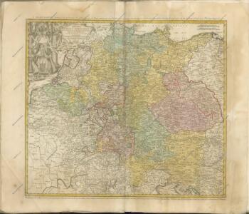
Special-Karte der Eisenbahn- Post- u[nd] Dampfschiff-Verbindungen Mittel-Europa's
1 : 1240000 Evropa střední Raab, Christian Johann Carl Koch, A. C. Flemming
Special-Karte der Eisenbahn- Post- u[nd] Dampfschiff-Verbindungen Mittel-Europa's
1 : 84000 Evropa střední Raab, Christian Johann Carl Müller, H. C. Flemming
Post- Reise-Karte von Deutschland mit spezieller Angabe der Eisenbahn- und Dampfschiffahrt-Verbindungen
1 : 1820000 Evropa střední Hagedorn, Fhr. von Löhe, Wilhelm von Piloty & Loehle
Neueste Post-Charte von Deutschland und den angränzenden Ländern : für Extraposten, Couriere, Diligencen u. Eilwagen / mit benützung der besten Materialien gezeichnet
1 : 1000000 Annotatie: Met afstandentabel Nürnberg : Bauer & Raspe
Post- und Reisekarte von Deutschland, den Niederlanden, Belgien und der Schweiz, nebst Theilen der angrenzenden Länder bis London, Havre de Grace, Turin, Warschau, Kopenhagen
1 : 2500000 Bachmann, Fr. Verlag der Friedrich Kornschen Buchhandlung
Germania, V. Nova Tabula. [Karte], in: Claud. Ptolemaeus. Geographia lat. cum mappis [...], S. 347.
1 Karte aus Atlas Münster, Sebastian [und Ptolemaeus, Claudius]
Imperium Romano-Germanicum
1 : 2600000 Mollova mapová sbírka Seutter, Matthäus Seutter, Matthäus
Germania, V. Nova Tabula. [Karte], in: Geographia universalis vetus et nova complectens Claudii Ptolemaei Alexandrini enarrationis libros VIII, S. 314.
1 Karte aus Atlas Münster, Sebastian [und Ptolemaeus, Claudius]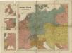
Prof. W. Liebenow's Kriegskarte von Mitteleuropa

Übersicht der Schnellpost und Eilwagen, ... Deutschland

Neueste Eisenbahn-Karte von Deutschland und den angrenzenden Ländern
Evropa střední Walseck, Georg Georg Walseck
Post und Reisekartre von Deutschland...

Post- und Reise-Karte von Deutschland und den anliegenden Laendern bis London, Havre de Grace, Tours, Lyon, Genua, Bologna, Pest, Warschau, Königsberg u. jenseits Kopenhagen, nebst den Haupt-Routen durch das übrige Europa
1 : 1490000 Belgie Diez, F. M. Perthes, Justus Justus Perthes
Post- und Reise-Karte von Deutschland und den anliegenden Ländern bis London, Havre de Grace, Tours, Lyon, Genua, Bologna, Pest, Warschau, Königsberg u. jenseits Kopenhagen, nebst den haupt Routen durch das übrige Europa
1 : 1490000 Belgie Diez, F. M. Justus Perthes
[Střední a západní Evropa]
1 : 2500000 Evropa střední
Hydrographica Germaniae...
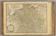
Germany.
1 : 2400000 Robert Laurie & James Whittle
Special-Karte der Eisenbahnen Deutschlands und der angrenzenden Länder
1 : 2000000 Haeberlin, R. Ramdohr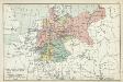
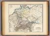
XII. Preußen innerhalb Deutschlands mit den angrenzenden Staatengebieten
1 : 6000000 Mitteleuropa, Deutschland
Post- und Reise-Charte von Deutschland und den benachbarten Laendern / nach den neuesten Quellen entw. von C.F. Weiland ; C.J. Maedel sculps.
1 : 1500000 Annotatie geografische gegevens: Grenzen gekleurd Weiland, C. F.; Maedel, C. J. Weimar : Geogr. Institut
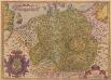
Imperium Romano-Germanicum
1 : 2600000 Mollova mapová sbírka Seutter, Matthäus Seutter, Matthäus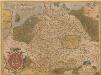
Germania. [Karte], in: Theatrum orbis terrarum, S. 40.
1 Karte aus Atlas Ortelius, Abraham
Mappa Geographica exhibens Postas
Germania. [Karte], in: Theatrum orbis terrarum, S. 102.
1 Karte aus Atlas Ortelius, Abraham
L' Empire D'Allemagne [...] [Karte], in: Atlas nouveau, contenant toutes les parties du monde [...], Bd. 1, S. 161.
1 Karte aus Atlas Sanson, Nicolas Jaillot, Alexis Hubert und Mortier, Pieter
[Kaart], uit: Reise-Karte von Mittel-Europa : mit Angabe der Bahnstationen und Postverbindungen / entworfen und gezeichnet von M. Hermann
1 : 2800000 titelvariant: Reisekarte von Mittel-Europa; Annotatie: Omslagtitel: Reisekarte von Mittel-Europa Hermann, M. Glogau : Carl Flemming