Maps of Germany

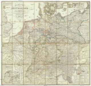
Post- und Reise-Karte von Deutschland und den anliegenden Laendern bis London, Havre de Grace, Tours, Lyon, Genua, Bologna, Pest, Warschau, Königsberg u. jenseits Kopenhagen, nebst den Haupt-Routen durch das übrige Europa
1 : 1490000 Belgie Diez, F. M. Perthes, Justus Justus Perthes
Post- und Reise-Karte von Deutschland und den anliegenden Ländern bis London, Havre de Grace, Tours, Lyon, Genua, Bologna, Pest, Warschau, Königsberg u. jenseits Kopenhagen, nebst den haupt Routen durch das übrige Europa
1 : 1490000 Belgie Diez, F. M. Justus Perthes
Post- und Reisekarte von Deutschland, den Niederlanden, Belgien und der Schweiz, nebst Theilen der angrenzenden Länder bis London, Havre de Grace, Turin, Warschau, Kopenhagen
1 : 2500000 Bachmann, Fr. Verlag der Friedrich Kornschen Buchhandlung
Übersicht der Schnellpost und Eilwagen, ... Deutschland

Verbreitung der wichtigsten Kulturgewächse
Evropa střední F.A. Brockhaus Geogr. artist. Anstalt
Post und Reisekartre von Deutschland...

Post- und Reise-Charte von Deutschland und den benachbarten Laendern / nach den neuesten Quellen entw. von C.F. Weiland ; C.J. Maedel sculps.
1 : 1500000 Annotatie geografische gegevens: Grenzen gekleurd Weiland, C. F.; Maedel, C. J. Weimar : Geogr. Institut
Imperium Romano-Germanicum
1 : 2600000 Mollova mapová sbírka Seutter, Matthäus Seutter, Matthäus
Reisekarte von Deutschland und den angrenzenden Ländern
Evropa střední Mahlmann, H. Morin, F. H. F.H. Morin
Post- und Eisenbahnkarte von Deutschland und den benachbarten Laendern
1 : 2450000 Evropa střední Weiland, Karl Ferdinand Mädel, C. J. Geograph. Institut
Reise - Karte von Deutschland und den Nachbarstaaten

Mappa Geographica exhibens Postas

Mitteleuropa Übersicht der Bodenverhältnisse
1 : 5000000 Mitteleuropa
Eisenbahn-Karte von Mittel-Europa
1 : 8200000 Evropa střední
Post- und Reisekarte von Deutschland, den Niederlanden, Belgien und der Schweiz
1 : 2470000 Belgie Bachmann, Friedrich Nast Friedr. Kornschen Buchhandlung
Post- und Reisekarte von Deutschland, den Niederlanden, Belgien und der Schweiz
1 : 2470000 Belgie Bachmann, Friedrich Nast Friedr. Kornschen Buchhandlung
Altgermanien, Sud-Donau-Lander, Mitte des Vten jahrhundert's.
1 : 3800000 Spruner von Merz, Karl
Post- und Eisenbahn-Reisekarte von Central-Europa
1 : 2000000 Evropa střední Franz, J. Handtke, Friedrich Carl Flemming
Tabula Germaniae
1 : 2780000 Evropa střední Visscher, Claes Jansz. Broeck, Abraham van den Claes Ianßen Visscher excudebat
Mitteleuropa Übersicht der politischen Verhältnisse und Hauptverkehrswege
1 : 5000000 Mitteleuropa Verkehrsnetz
[Kaart], uit: Reise-Karte von Mittel-Europa : mit Angabe der Bahnstationen und Postverbindungen / entworfen und gezeichnet von M. Hermann
1 : 2800000 titelvariant: Reisekarte von Mittel-Europa; Annotatie: Omslagtitel: Reisekarte von Mittel-Europa Hermann, M. Glogau : Carl Flemming
Deutschland physikalisch.
1 : 3400000 Andree, Richard
Prof. W. Liebenow's Kriegskarte von Mitteleuropa

Imperium Romano-Germanicum
1 : 2600000 Mollova mapová sbírka Seutter, Matthäus Seutter, Matthäus
Germania, V. Nova Tabula. [Karte], in: Claud. Ptolemaeus. Geographia lat. cum mappis [...], S. 347.
1 Karte aus Atlas Münster, Sebastian [und Ptolemaeus, Claudius]

Germania, V. Nova Tabula. [Karte], in: Geographia universalis vetus et nova complectens Claudii Ptolemaei Alexandrini enarrationis libros VIII, S. 314.
1 Karte aus Atlas Münster, Sebastian [und Ptolemaeus, Claudius]
L'Allemagne
1 : 2500000 L'Isle, Guillaume de Dezauche
VIII. Charte für die allgemeine Geschichte von Rudolph von Habsburg bis auf Carl V : d.i. von 1273-1519 nach Christus
Entworfen von F.W. Benicken gez. von C.F. Weiland ; in Stein gravirt v. Ant. Falger Weimar : im Verlage des L. Industrie-Comptoirs
Deutschland, Ubersicht Des Deutschen Reichs.
1 : 3700000 Berghaus, Hermann