Maps of Carpathian Mountains

Magyarország úthálózatának térképe
1 : 1300000 Maďarsko Homolka, Josef Eggenberger féle könyvkereskedés (Hofmann Alfréd)
Hungary
1 : 1000000 Hongrie. S.G.A. le 20/12/19. In: Treaty Series No. 10.1920. Treaty of Peace between the Allied and Associated Powers and Hungary. June 4, 1920. War Office
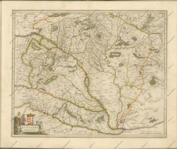
Ungarn und seine Nachbarländer 1919-1938
Ungarn
Das Königreich Ungarn nach seiner natürlichen und politischen Ansicht. Übersicht der Komitate
Ungarn Kroatien Verwaltungsbezirk Komitat
Postkarte des Königreichs Ung.Übersciht von Wien über Ofen bis Kronstadt ; und von Venedig, Triest, Fiume bis Lemberg und Brody
Ungarn Kroatien Postroute Verkehrsweg
Magyarország és a' Hozzá kapcsolt tartományok Földabrosza
1 : 970000 Chorvatsko Raffelsperger, Franz Raffelsperger F.

Die kaiserl. oesterreichischen ungarischen Erbstaaten
1 : 2276000 Maďarsko Weiland, Karl Ferdinand Jungmann, Carl im Verlage des Geograph. Instituts
Hungary.
1 : 3800000 Darton, William
Hungariae Regnum. [Karte], in: Novus atlas absolutissimus, Bd. 2, S. 285.
1 Karte aus Atlas Janssonius Offizin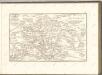
Strassen-Karte des Koenigreiches Ungarn
1 : 430000 Uhersko A. Floder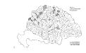
Die konservativen Wahlbezirke
Ungarn Wahlbezirk, Wahlverhalten
Karte der Königreiche Ungarn, Croatien, Slavonien und Militärgrenzen
Karte des ungarischen Communikations-Netzes
1 : 1140000 Evropa jihovýchodní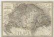
Magyar-ország
1 : 1400000 Chorvatsko Fried, Franz List, Joseph bei Artaria &. Comp.
Carte Particuliere De La Hongrie De La Transilvanie De La Croatie Et De La Sclavonie
1 : 1400000 Mollova mapová sbírka Delisle, Guillaume Schenk, Peter II
Carte Particuliere De La Hongrie De La Transilvanie De La Croatie Et De La Sclavonie
1 : 1400000 Mollova mapová sbírka Delisle, Guillaume L'Isle, Guillaume de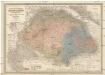
Die kaiserlich Oesterreichischen Ungarischen Erbstaaten
1 : 522000 Budapešť-oblast (Maďarsko) Weiland, Karl Ferdinand im Verlage des Geographischen Instituts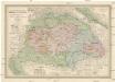
Die kaiserlich Oesterreichischen Ungarischen Erbstaaten
Maďarsko Weiland, Karl Ferdinand Prixner, Godofr. im Verlage des Geographischen Instituts
Die kaiserlich Oesterreichischen Ungarischen Erbstaaten
Maďarsko Weiland, Karl Ferdinand Prixner, Godofr. im Verlage des Geographischen Instituts
Die kaiserlich Oesterreichischen Ungarischen Erbstaaten
Maďarsko Weiland, Karl Ferdinand Prixner, Godofr. im Verlage des Geographischen Instituts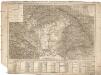
Tabula generalis regni Hungariae Croatiae et Slavoniae, nec non magni principatus Transylvaniae conspectum mappae generalis in IX. sectiones moduli majoris distributae civitates, oppida, stationes et vias postales singillatim accurateque exhibens
1 : 1396000 Chorvatsko Lipský, Ján Karacs, Ferenc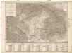
Tabula generalis regni Hungariae Croatiae et Slavoniae, nec non magni principatus Transylvaniae conspectum mappae generalis in IX. sectiones moduli majoris distributae civitates, oppida, stationes et vias postales singillatim accurateque exhibens
1 : 1400000 Chorvatsko Lipský, Ján Festetits de Tolna, Georgio
Die Münzkammer-Gebiete Ungarns bis 1395
Ungarn Münzwesen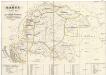
Karte von Ungarn
Maďarsko Torsch, Franz
Tabula generalis regni Hungariae, Croatiae et Slavoniae nec non magni principatus Tranylvaniae
1 : 1400000 Chorvatsko Lipský, Ján Marcum Berra
Hongrie, Transilvanie, Sclavonie, Croatie, Valaquie, Bosnie, Bulgarie.
1 : 1450000 Robert de Vaugondy, Gilles, 1688-1766
Allgemeine Charte vom Königreiche Ungarn
1 : 1500000 Chorvatsko Liechtenstern, Joseph Marx von Berken von Ottendorff, Johann Kunst und Industrie Comptoirs