Maps of Valbondione

Blatt XXV: Höhen der vorzüglichsten Punkte, uit: Topographische Karte der Schweiz / vermessen und hrsg. ... unter Aufsicht des Generals G.H. Dufour
1 : 100000 Annotatie: Met plaatsnamenregister (bl. V), bladwijzer (bl. XXI) en hoogteregister (bl. XXV); Voor aanwezige bladen zie overzichtsblad Dufour, G. H. [Bern : Eidg. Topogr. Bureau]
Topographische Karte der Schweiz (Dufour-Karte): Den Kanton Zürich betreffende Blätter: Blatt XXV: Bergamo; Liste mit Höhenangaben (Höhen der vorzüglichsten Punkte)
1 : 100000 Leitung: Dufour, Guillaume-Henri (1787-1875), General, Politiker, Ingenieur und Kartograf, von Genf; Eidgenössisches Topographisches Bureau, in Genf Stich: Stempelmann, J. (1835-1887)
Territorio di Bergamo
1 : 280000 Bergamo (Itálie : provincie) Janssonius, Johannes Ioannes Iansonius
Carte Nouvelle Du Bergamasco Faisant Partie des Etats de la Republique de Venise [...] [Karte], in: Atlas nouveau, contenant toutes les parties du monde [...], Bd. 2, S. 168.
1 Karte aus Atlas Sanson, Nicolas Jaillot, Alexis Hubert und Mortier, Pieter
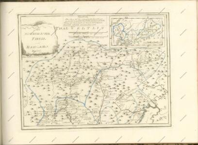
Partie de la Valteline et frontière de l'Italie
1 : 108000 Weiss, Johann Heinrich ; Scheuermann, Johann Jakob ; Meyer, Johann Rudolf J. R. Meyer
TERRITORIO | DI | BERGAMO
[Amsterdam : Joan Blaeu]

Territorio Di Bergamo [Karte], in: Novus Atlas, das ist, Weltbeschreibung, Bd. 3, S. 109.
1 Karte aus Atlas Blaeu, Joan Blaeu, Willem Janszoon
Territorio Di Bergamo [Karte], in: Theatrum orbis terrarum, sive, Atlas novus, Bd. 3, S. 91.
1 Karte aus Atlas Blaeu, Joan Blaeu, Willem Janszoon
Territorio Di Bergamo [Karte], in: Le théâtre du monde, ou, Nouvel atlas contenant les chartes et descriptions de tous les païs de la terre, Bd. 3, S. 105.
1 Karte aus Atlas Blaeu, Willem Janszoon und Blaeu, Joan Blaeu, Willem Janszoon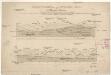
Heerstrasse über das Stilfser Joch oder die Wormses Strasse
Inst. Bibl.
Carte Tres particuliere du Bergamasco
1 : 280000 Mollova mapová sbírka Nolin, Jean-Baptiste Nolin, Jean Baptiste
Partie de la Valteline et frontiere de l' Italie.
From Atlas Suisse. Levé et dessiné par J. H. Weiss aux fraix de J. R. Meyer á Aarau dans les années 1786 á 1802. Gravée par Guerin, Eichler, et Scheurmann.
Milano
1 : 200000 Herder, Bartholomew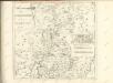

Carte delle prealpi di Lecco
1 : 100000 Grassi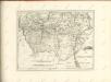

Fin de la bataille de Cassano
Italien Cassano d'Adda Koalitionskrieg <1798-1802> Suvorov, Aleksandr V. A.N.C.
Atlas Suisse
1 : 120000 16 Karten levé et dessiné par J.H. Weiss [et Joachim Eugen Müller] aux frais de J.R. Meyer à Aarau dans les années 1786 à 1802 ; gravée [sic] par [Christophe] Guérin, [Matthias Gottfried] Eichler et [Johann Jakob] Scheurmann [Johann Rudolf Meyer], Aarau
Territorio Di Bergamo [Karte], in: Novus atlas absolutissimus, Bd. 5, S. 26.
1 Karte aus Atlas Janssonius Offizin
Schulwandkarte zur Geschichte der Schweiz
1 : 180000 Südost-Blatt Oechsli, Wilhelm ; Baldamus, Alfred Kartograph. Verlagsanstalt von Georg Lang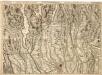
Environ de Varesse et Ugogna = Environs de Bergam, Come, et Lecco
1 : 120000 Mollova mapová sbírka Dheulland, Guillaume Dheulland, Guillaume
Distanzenkarte von der Schweiz
1 : 200000 1 Karte in 8 Teilen nach den besten Hülfsquellen bearb. von R. Huber Wagner, Bern
Reisekarte der Schweiz
1 : 500000 1 Atlas (1, 6 Bl.) gezeichnet von H. Keller und gestochen von J. Scheurmann = Carte routière de la Suisse / dessinée par H. Keller et gravée par J. Scheurmann bey Fuessli und Comp., Zürich
Wandkarte der Schweiz
1 : 200000 1 Karte auf 8 Blättern J.M. Ziegler Wurster, Winterthur
TERRITORIO | di | BRESCIA | et di | CREMA
Apud Guiljelmum | et Joannem Blaeu
Milano
1 : 200000 1 Karte entworfen und bearbeitet von Woerl ; in Stein gestochen unter seiner Leitung 1835 ; Lithographie von B. Herder Herder, Freiburg im Breisgau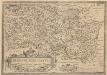
Bresciano Brixiani Agri Typus. Brixia, Cygnea supposita in specula. [Karte], in: Theatrum orbis terrarum, S. 299.
1 Karte aus Atlas Ortelius, Abraham Vrients, Jan Baptista