Maps of Como

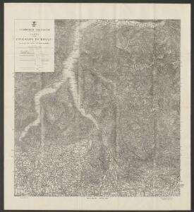
Carte delle prealpi di Lecco
1 : 100000 Grassi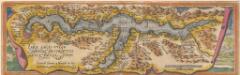
Larii Lacus Culgo Comensis Descirptio [Karte], in: Theatrum orbis terrarum, S. 214.
1 Karte aus Atlas Ortelius, Abraham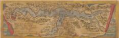
Larii Lacus Vulgo Comensis Descriptio [Karte], in: Theatrum orbis terrarum, S. 85.
1 Karte aus Atlas Ortelius, Abraham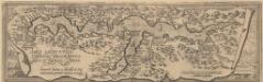
Larii Lacus Culgo Comensis Descirptio [Karte], in: Theatrum orbis terrarum, S. 309.
1 Karte aus Atlas Ortelius, Abraham Vrients, Jan Baptista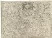
Parte Alpestre dello Stato di Milano
1 : 330000 Mollova mapová sbírka Magini, Fabio Magini, Fabio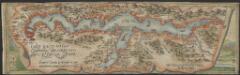
Larii Lacus vulgo Comensis descriptio : excurrit Larius a Meridie in Septentrionem, pronior tamen in Oriente
1 : 150000 auct. Paulo Jovio [S.l.] : [s.n.]
Larii lacvs vvlgo Comensis descriptio
3 Karten auf 1 Blatt : Kupferdruck ; zusammen 34 x 49 cm Giovio; Ortelius s.n.
Larii lacvs vvlgo Comensis descriptio
3 Karten auf 1 Blatt : Kupferdruck ; 34 x 49 cm Giovio; Ortelius s.n.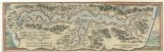
Larii Lacvs Uvlgo Comensis Descriptio
Mollova mapová sbírka Giovio, Paolo Coppens van Diest, Gillis
Zu Bildner des Heeres Beilage 24
K.k. Schulbücher-Verschleiss-Administration
Pianta topografica della citta di Bergamo
Bergamo (Itálie) Botta, Giacomo
Strittige Grenze zwischen der Schweiz und dem Herzogtum Mailand bei Ponte Colla, Bogno, Certara, Sonvico, Cavargna und Sighebia; Grundriss
1 : 8000 Mit Legende und 2 Siegeln. Portigliotti, Gaudenzo, Ingenieur; Caresana, Giuseppe, Ingenieur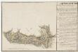
Grenze zwischen der Schweiz und dem Herzogtum Mailand bei Caneggio und Moltrasio; Grundriss
1 : 8000 Mit Legende. Caresana, Giuseppe, Ingenieur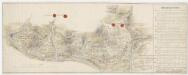
Strittige Grenze zwischen der Schweiz und dem Herzogtum Mailand bei Bruzella, Caneggio und Moltrasio; Grundriss
1 : 8000 Mit Legende und 4 Siegeln. Portigliotti, Gaudenzo, Ingenieur; Caresana, Giuseppe, Ingenieur; Cozzi, G., Geom.
Pianta della citta e borghi esterni di Bergamo dedicata alla citta medesima
Bergamo (Itálie) Manzini, Giuseppe Aloja, Vincenzo Giuseppe Manzini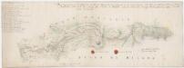
Strittige Grenze zwischen der Schweiz und dem Herzogtum Mailand bei Vacallo, Sagno, Morbio superiore, Caneggio, Bruzella, Schignano, Mezzena, Moltrasio, Rovena, Piazza und Masilianico; Grundriss
1 : 8000 Mit Legende und 2 Siegeln. Portigliotti, Gaudenzo, Ingenieur; Caresana, Giuseppe, Ingenieur
Strittige Grenze zwischen der Schweiz und dem Herzogtum Mailand bei Rovio, Castel San Pietro, Muggio, Cabbio, Bruzella, Caneggio, Sante Fedele, Erbon, Cerano, Casasco und Schignano; Grundriss
1 : 8000 Mit Legende und 2 Siegeln. Portigliotti, Gaudenzo, Ingenieur; Caresana, Giuseppe, Ingenieur
Atlas Suisse
1 : 120000 16 Karten levé et dessiné par J.H. Weiss [et Joachim Eugen Müller] aux frais de J.R. Meyer à Aarau dans les années 1786 à 1802 ; gravée [sic] par [Christophe] Guérin, [Matthias Gottfried] Eichler et [Johann Jakob] Scheurmann [Johann Rudolf Meyer], Aarau
Milano
1 : 200000 Herder, Bartholomew
Partie de la Valteline et frontiere de l' Italie.
From Atlas Suisse. Levé et dessiné par J. H. Weiss aux fraix de J. R. Meyer á Aarau dans les années 1786 á 1802. Gravée par Guerin, Eichler, et Scheurmann.
Territorio Di Bergamo [Karte], in: Novus atlas absolutissimus, Bd. 5, S. 26.
1 Karte aus Atlas Janssonius Offizin
Territorio Di Bergamo [Karte], in: Le théâtre du monde, ou, Nouvel atlas contenant les chartes et descriptions de tous les païs de la terre, Bd. 3, S. 105.
1 Karte aus Atlas Blaeu, Willem Janszoon und Blaeu, Joan Blaeu, Willem Janszoon
Partie de la Valteline et frontière de l'Italie
1 : 108000 Weiss, Johann Heinrich ; Scheuermann, Johann Jakob ; Meyer, Johann Rudolf J. R. Meyer
Territorio Di Bergamo [Karte], in: Theatrum orbis terrarum, sive, Atlas novus, Bd. 3, S. 91.
1 Karte aus Atlas Blaeu, Joan Blaeu, Willem Janszoon
TERRITORIO | DI | BERGAMO
[Amsterdam : Joan Blaeu]

Territorio di Bergamo
1 : 280000 Bergamo (Itálie : provincie) Janssonius, Johannes Ioannes Iansonius
Nuova carta topografica dei tre laghi Maggiore, di Lugano e di Como
1 : 180000 Como, jezero (Itálie) Ostinelli, Carlo Antonio C. A. Ostinelli
Carta di viaggio da Milano ai tre laghi Maggiore di Lugano e di Como e nelle loro vicinanze
1 : 170000 Como, jezero (Itálie)