Maps of Bergamo
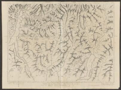
Partie de la Valteline et frontière de l'Italie
1 : 108000 Weiss, Johann Heinrich ; Scheuermann, Johann Jakob ; Meyer, Johann Rudolf J. R. Meyer
Atlas Suisse
1 : 120000 16 Karten levé et dessiné par J.H. Weiss [et Joachim Eugen Müller] aux frais de J.R. Meyer à Aarau dans les années 1786 à 1802 ; gravée [sic] par [Christophe] Guérin, [Matthias Gottfried] Eichler et [Johann Jakob] Scheurmann [Johann Rudolf Meyer], Aarau
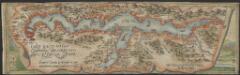
Territorio Di Bergamo [Karte], in: Novus atlas absolutissimus, Bd. 5, S. 26.
1 Karte aus Atlas Janssonius Offizin
Territorio Di Bergamo [Karte], in: Le théâtre du monde, ou, Nouvel atlas contenant les chartes et descriptions de tous les païs de la terre, Bd. 3, S. 105.
1 Karte aus Atlas Blaeu, Willem Janszoon und Blaeu, Joan Blaeu, Willem Janszoon
Territorio Di Bergamo [Karte], in: Theatrum orbis terrarum, sive, Atlas novus, Bd. 3, S. 91.
1 Karte aus Atlas Blaeu, Joan Blaeu, Willem Janszoon

TERRITORIO | DI | BERGAMO
[Amsterdam : Joan Blaeu]
Territorio Di Bergamo [Karte], in: Novus Atlas, das ist, Weltbeschreibung, Bd. 3, S. 109.
1 Karte aus Atlas Blaeu, Joan Blaeu, Willem Janszoon
Territorio di Bergamo
1 : 280000 Bergamo (Itálie : provincie) Janssonius, Johannes Ioannes Iansonius
Carte Nouvelle Du Bergamasco Faisant Partie des Etats de la Republique de Venise [...] [Karte], in: Atlas nouveau, contenant toutes les parties du monde [...], Bd. 2, S. 168.
1 Karte aus Atlas Sanson, Nicolas Jaillot, Alexis Hubert und Mortier, Pieter
Partie de la Valteline et frontiere de l' Italie.
From Atlas Suisse. Levé et dessiné par J. H. Weiss aux fraix de J. R. Meyer á Aarau dans les années 1786 á 1802. Gravée par Guerin, Eichler, et Scheurmann.
Blatt XXV: Höhen der vorzüglichsten Punkte, uit: Topographische Karte der Schweiz / vermessen und hrsg. ... unter Aufsicht des Generals G.H. Dufour
1 : 100000 Annotatie: Met plaatsnamenregister (bl. V), bladwijzer (bl. XXI) en hoogteregister (bl. XXV); Voor aanwezige bladen zie overzichtsblad Dufour, G. H. [Bern : Eidg. Topogr. Bureau]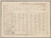
Topographische Karte der Schweiz (Dufour-Karte): Den Kanton Zürich betreffende Blätter: Blatt XXV: Bergamo; Liste mit Höhenangaben (Höhen der vorzüglichsten Punkte)
1 : 100000 Leitung: Dufour, Guillaume-Henri (1787-1875), General, Politiker, Ingenieur und Kartograf, von Genf; Eidgenössisches Topographisches Bureau, in Genf Stich: Stempelmann, J. (1835-1887)
Carte Tres particuliere du Bergamasco
1 : 280000 Mollova mapová sbírka Nolin, Jean-Baptiste Nolin, Jean Baptiste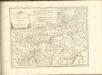

Carte delle prealpi di Lecco
1 : 100000 Grassi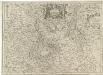
Parte Alpestre dello Stato di Milano
1 : 330000 Mollova mapová sbírka Magini, Fabio Magini, Fabio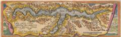
Larii Lacus Culgo Comensis Descirptio [Karte], in: Theatrum orbis terrarum, S. 214.
1 Karte aus Atlas Ortelius, Abraham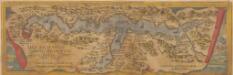
Larii Lacus Vulgo Comensis Descriptio [Karte], in: Theatrum orbis terrarum, S. 85.
1 Karte aus Atlas Ortelius, Abraham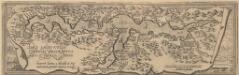
Larii Lacus Culgo Comensis Descirptio [Karte], in: Theatrum orbis terrarum, S. 309.
1 Karte aus Atlas Ortelius, Abraham Vrients, Jan Baptista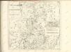
Larii Lacus vulgo Comensis descriptio : excurrit Larius a Meridie in Septentrionem, pronior tamen in Oriente
1 : 150000 auct. Paulo Jovio [S.l.] : [s.n.]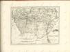

Larii lacvs vvlgo Comensis descriptio
3 Karten auf 1 Blatt : Kupferdruck ; zusammen 34 x 49 cm Giovio; Ortelius s.n.
Larii lacvs vvlgo Comensis descriptio
3 Karten auf 1 Blatt : Kupferdruck ; 34 x 49 cm Giovio; Ortelius s.n.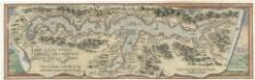
Larii Lacvs Uvlgo Comensis Descriptio
Mollova mapová sbírka Giovio, Paolo Coppens van Diest, Gillis
Fin de la bataille de Cassano
Italien Cassano d'Adda Koalitionskrieg <1798-1802> Suvorov, Aleksandr V. A.N.C.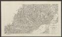
Carte delle valli del Liro e di Livio
1 : 50000 Grassi
Zu Bildner des Heeres Beilage 24
K.k. Schulbücher-Verschleiss-Administration