Maps of Bergamo

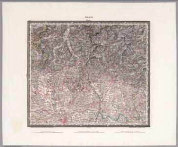
Milano
1 : 200000 Herder, Bartholomew
Territorio Di Bergamo [Karte], in: Le théâtre du monde, ou, Nouvel atlas contenant les chartes et descriptions de tous les païs de la terre, Bd. 3, S. 105.
1 Karte aus Atlas Blaeu, Willem Janszoon und Blaeu, Joan Blaeu, Willem Janszoon
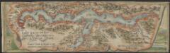
TERRITORIO | DI | BERGAMO
[Amsterdam : Joan Blaeu]
Territorio Di Bergamo [Karte], in: Theatrum orbis terrarum, sive, Atlas novus, Bd. 3, S. 91.
1 Karte aus Atlas Blaeu, Joan Blaeu, Willem Janszoon

Carte Nouvelle Du Bergamasco Faisant Partie des Etats de la Republique de Venise [...] [Karte], in: Atlas nouveau, contenant toutes les parties du monde [...], Bd. 2, S. 168.
1 Karte aus Atlas Sanson, Nicolas Jaillot, Alexis Hubert und Mortier, Pieter
Carte Tres particuliere du Bergamasco
1 : 280000 Mollova mapová sbírka Nolin, Jean-Baptiste Nolin, Jean Baptiste
Parte Alpestre dello Stato di Milano
1 : 330000 Mollova mapová sbírka Magini, Fabio Magini, Fabio

Territorio di Bergamo
1 : 280000 Bergamo (Itálie : provincie) Janssonius, Johannes Ioannes Iansonius
Carte delle prealpi di Lecco
1 : 100000 Grassi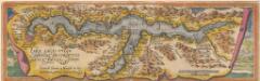
Larii Lacus Culgo Comensis Descirptio [Karte], in: Theatrum orbis terrarum, S. 214.
1 Karte aus Atlas Ortelius, Abraham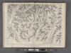
Partie de la Valteline et frontiere de l' Italie.
From Atlas Suisse. Levé et dessiné par J. H. Weiss aux fraix de J. R. Meyer á Aarau dans les années 1786 á 1802. Gravée par Guerin, Eichler, et Scheurmann.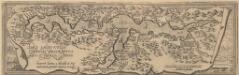
Larii Lacus Culgo Comensis Descirptio [Karte], in: Theatrum orbis terrarum, S. 309.
1 Karte aus Atlas Ortelius, Abraham Vrients, Jan Baptista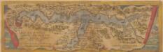
Larii Lacus Vulgo Comensis Descriptio [Karte], in: Theatrum orbis terrarum, S. 85.
1 Karte aus Atlas Ortelius, Abraham
Topographische Karte der Schweiz
1 : 100000 25 Karten vermessen und hrsg. auf Befehl der Eidgenössischen Behörden ; aufgenommen unter der Aufsicht des Generals G.H. Dufour Eidg. Topographisches Bureau, [Genève], [später: Bern]
Blatt XXIV: Lugano, Como, uit: Topographische Karte der Schweiz / vermessen und hrsg. ... unter Aufsicht des Generals G.H. Dufour
1 : 100000 Annotatie: Met plaatsnamenregister (bl. V), bladwijzer (bl. XXI) en hoogteregister (bl. XXV); Voor aanwezige bladen zie overzichtsblad Dufour, G. H. [Bern : Eidg. Topogr. Bureau]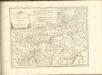
Larii Lacus vulgo Comensis descriptio : excurrit Larius a Meridie in Septentrionem, pronior tamen in Oriente
1 : 150000 auct. Paulo Jovio [S.l.] : [s.n.]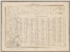
Topographische Karte der Schweiz (Dufour-Karte): Den Kanton Zürich betreffende Blätter: Blatt XXV: Bergamo; Liste mit Höhenangaben (Höhen der vorzüglichsten Punkte)
1 : 100000 Leitung: Dufour, Guillaume-Henri (1787-1875), General, Politiker, Ingenieur und Kartograf, von Genf; Eidgenössisches Topographisches Bureau, in Genf Stich: Stempelmann, J. (1835-1887)
Blatt XXV: Höhen der vorzüglichsten Punkte, uit: Topographische Karte der Schweiz / vermessen und hrsg. ... unter Aufsicht des Generals G.H. Dufour
1 : 100000 Annotatie: Met plaatsnamenregister (bl. V), bladwijzer (bl. XXI) en hoogteregister (bl. XXV); Voor aanwezige bladen zie overzichtsblad Dufour, G. H. [Bern : Eidg. Topogr. Bureau]
Fin de la bataille de Cassano
Italien Cassano d'Adda Koalitionskrieg <1798-1802> Suvorov, Aleksandr V. A.N.C.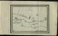
Bataille de Cassano
Italien Cassano d'Adda Koalitionskrieg <1798-1802> Suvorov, Aleksandr V. A.N. Champ
[Comer See und Umgebung]
1 : 256000 Alpy italské (pohoří)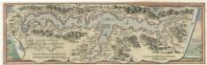
Larii Lacvs Uvlgo Comensis Descriptio
Mollova mapová sbírka Giovio, Paolo Coppens van Diest, Gillis
Larii lacvs vvlgo Comensis descriptio
3 Karten auf 1 Blatt : Kupferdruck ; zusammen 34 x 49 cm Giovio; Ortelius s.n.
Larii lacvs vvlgo Comensis descriptio
3 Karten auf 1 Blatt : Kupferdruck ; 34 x 49 cm Giovio; Ortelius s.n.
Die schweizerischen Landvogteyen Lauis und Mendris nebst den Grentzen von Bellenz, Luggaris und mayländischen Gebiet
1 Karte : Kupferdruck ; 46 x 37 cm Finsler; Clausner s.n.
Bataille de Verderio
Italien Verderio Koalitionskrieg <1798-1802> Suvorov, Aleksandr V. A.N.C.