Maps of Italy
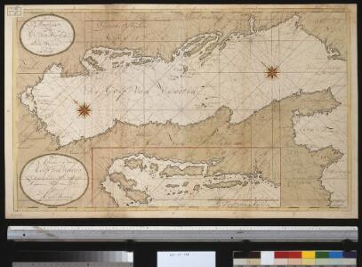
Nette afteekening van de Golf van Venetia vertoonende alle desselfs haavenen reede en baije in grood besteck
Italy Gerard van Keulen
Tabula Italiae
1 : 2900000 Mollova mapová sbírka Visscher, Nicolaes Visscher, Nicolaus I.
TABULA ITALIAE, Corsicae, Sardiniae, et adjacentium Regnorum, nec non viva praecipuarum Urbium, Locorum, Insignium, et Vestituum
1 : 2640000 Benátky (Itálie) Visscher, Claes Jansz. Goos, Abraham Nicolai Johannis Visscher
ITALIAE ANTIQUAE Novissima Tabula
Itálie Clüver, Philipp Visscher, Nicolaes Jansz. ex officina Nicolai Visscher
Nova Italiae delineatio
1 : 3000000 Itálie
[XVIII], uit: Geognostische Karte des Oesterreichischen Kaiserstaates mit einem grossen Theile Deutschland's u. Italien / hauptsachlich nach ... Haidinger's geognostischer Karte dieses Staates bearb. von Josef Scheda
1 : 3000000 titelvariant: General-Karte von Europa in 25 Blättern; Annotatie: Bijlage bij: General-Karte von Europa in 25 Blättern. - 1:2.592.000. - 1845-1847 Scheda, Joseph Wien : K.K. Militär. Geografisch. Institut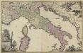
Novissima et accuratissima totius Italiae Corsicae et Sardiniae descriptio
1 : 1600000 correcta mu[l]tis aucta et in lucem edita per Gerardum Valk Amst. Bat. Luggert van Anse schulp. ; [bij het vignet:] Ph. Tideman inventor ; G. v. Gouwen fec. Amst. Bat. : per Gerardum Valk
Im Aeroplan von der Adria zu den Alpen
Italia Antiqua Philippo Cluvero Borusso Designatore [Karte], in: Gerardi Mercatoris et I. Hondii Newer Atlas, oder, Grosses Weltbuch, Bd. 2, S. 212.
1 Karte aus Atlas Mercator, Gerhard und Hondius, Jodocus Jansson, Jan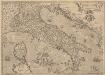
Italiae Novissima Descriptio [Karte], in: Theatrum orbis terrarum, S. 284.
1 Karte aus Atlas Ortelius, Abraham Vrients, Jan Baptista
P. Cluverii Italia antiqva cum insulis adiacentibus Sicilia, Corsica et Sardania adiectae sunt et Illyride Libvrnia, et Dalmatia circumuicinaru[m]q[ue] regionu[m] partes alicot
1 : 2400000 Dalmácie (Chorvatsko) Clüver, Philipp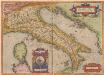
Italiae Veteris Specimen. [Karte], in: Theatrum orbis terrarum, S. 386.
1 Karte aus Atlas Ortelius, Abraham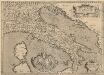
Italiae Veteris Specimen. [Karte], in: Theatrum orbis terrarum, S. 487.
1 Karte aus Atlas Ortelius, Abraham Vrients, Jan Baptista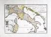
Nouvelle carte de l'Italie
1 Karte : Typometrie ; 31 x 46 cm Haas G. Haas
Vzducholodí přes Italii a Dardanely
Dardanely (Turecko : průliv) Melantrich
Italia Antiqva
1 : 8400000 Mollova mapová sbírka Clüver, Philipp Fuhrmann, Mathias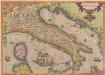
Italiae Novissima Descriptio [Karte], in: Theatrum orbis terrarum, S. 189.
1 Karte aus Atlas Ortelius, Abraham
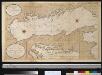
Das Adriatische Meer
Stieler's Hand-Atlas Stieler, Adolf bei Justus Perthes
Plastická mapa Italie a přímořských zemí rakouských
Itálie Batěk, J. Emil Šolc
Karta srednej i južnoj Italīi
Italien Seeschlacht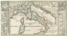
Italien für die Reisende.
1 : 1690000 Mollova mapová sbírka Bodenehr, Gabriel Bodenehr, Gabriel

Nova Italiae Delineatio
1 : 3600000 Mollova mapová sbírka Merian, Matthaeus Merian, Matthäus - dědici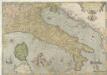
Italiae Novissima Descriptio
1 : 2800000 Mollova mapová sbírka Gastaldi, Jacobo
Italiae antiquae tabula geographica cum Insulis adjacentibus
Italia [Karte], in: Gerardi Mercatoris Atlas, sive, Cosmographicae meditationes de fabrica mundi et fabricati figura, S. 425.
1 Karte aus Atlas Mercator, Gerhard Montanus, Petrus
Italiae antiquae tabula geographica
1 : 5410000 Itálie Berra, Marco Marco Berra
Tabula Italiae Antiquae geographica.
1 : 2050000 Anville, Jean Baptiste Bourguignon d, 1697-1782
Le golfe de Venise
1 Karte : Kupferdruck ; 51 x 58 cm Fer; Starckman chez l'auteur dans l'isle du Palais sur le quay de l'Orloge a la Sphere Royale