Maps of Italy
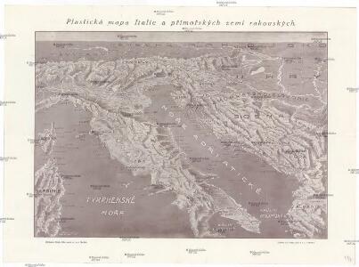
Plastická mapa Italie a přímořských zemí rakouských
Itálie Batěk, J. Emil Šolc
TABULA ITALIAE, Corsicae, Sardiniae, et adjacentium Regnorum, nec non viva praecipuarum Urbium, Locorum, Insignium, et Vestituum
1 : 2640000 Benátky (Itálie) Visscher, Claes Jansz. Goos, Abraham Nicolai Johannis Visscher
ITALIAE ANTIQUAE Novissima Tabula
Itálie Clüver, Philipp Visscher, Nicolaes Jansz. ex officina Nicolai Visscher
Tabula Italiae
1 : 2900000 Mollova mapová sbírka Visscher, Nicolaes Visscher, Nicolaus I.
Italiae Novissima Descriptio [Karte], in: Theatrum orbis terrarum, S. 284.
1 Karte aus Atlas Ortelius, Abraham Vrients, Jan Baptista
Italiae Veteris Specimen. [Karte], in: Theatrum orbis terrarum, S. 386.
1 Karte aus Atlas Ortelius, Abraham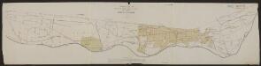
Italia Antiqua Philippo Cluvero Borusso Designatore [Karte], in: Gerardi Mercatoris et I. Hondii Newer Atlas, oder, Grosses Weltbuch, Bd. 2, S. 212.
1 Karte aus Atlas Mercator, Gerhard und Hondius, Jodocus Jansson, Jan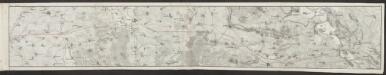
Italia [Karte], in: Gerardi Mercatoris Atlas, sive, Cosmographicae meditationes de fabrica mundi et fabricati figura, S. 425.
1 Karte aus Atlas Mercator, Gerhard Montanus, Petrus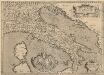
Italiae Veteris Specimen. [Karte], in: Theatrum orbis terrarum, S. 487.
1 Karte aus Atlas Ortelius, Abraham Vrients, Jan Baptista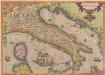
Italiae Novissima Descriptio [Karte], in: Theatrum orbis terrarum, S. 189.
1 Karte aus Atlas Ortelius, Abraham
Italiae Antiquae Nova Delinatio. [Karte], in: Novus atlas absolutissimus, Bd. 5, S. 8.
1 Karte aus Atlas Janssonius Offizin

Italia Nuovamente piu perfetta che mai per inanzi posta in luce, scolpita et con le suoi figure vivamente rappresentate [Karte], in: Gerardi Mercatoris et I. Hondii Newer Atlas, oder, Grosses Weltbuch, Bd. 2, S. 218.
1 Karte aus Atlas Mercator, Gerhard und Hondius, Jodocus Jansson, Jan
Nova Italiae delineatio
1 : 3000000 Itálie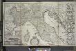
A new map of the upper part of Italy, containing ye principality of Piemont ye Dutchies of Savoy, Milan, Parma, Mantua, Modena, Tuscany, the dominions of ye Pope &c., the Republiques of Venice, Genoa, Lucca &c.
from The world described, or, A new and correct sett of maps : shewing the kingdoms and states in all the known parts of the earth, with the principal cities, and most considerable towns in the world ... / ... by Herman Moll, geographer ...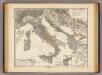
Italia, Gallia cisalpina, Sicilia, Sardinia, Corsica ab adventu Gallorum usque ad bellum Marsicum.
1 : 3900000 Menke, Th.
Carte de l'Italie et des pais circonuoisins
1 : 2490000 Itálie Sanson, Nicolas Magini, Giovanni Antonio par Melchior Tauernier
Kaart van Italië c.a.
1 : 3500000 titelvariant: Italië; Annotatie: Titel rechtsonder: Italië [S.l. : s.n.]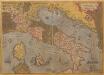
Italiae Novissima Descriptio [Karte], in: Theatrum orbis terrarum, S. 79.
1 Karte aus Atlas Ortelius, Abraham
Italia Nuovamente piu perfetta che mai per inanzi posta in luce, scolpita et con le suoi figure vivamente rappresentate [Karte], in: Novus atlas absolutissimus, Bd. 5, S. 11.
1 Karte aus Atlas Janssonius Offizin
Carta ferroviaria d ́Italia

Nova Italiae Delineatio [Karte], in: Theatrum orbis terrarum, sive, Atlas novus, Bd. 3, S. 10.
1 Karte aus Atlas Blaeu, Joan Blaeu, Willem Janszoon
Totius Italiae tabula
1 : 2850000 Itálie Visscher, Nicolaus per Nicolaum Visscher
Atlante fisico economico d'Italia
1 : 5000000 Danielli, Giotto Consociazione turistica italiana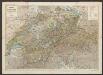
Nova Italiae Delineatio [Karte], in: Le théâtre du monde, ou, Nouvel atlas contenant les chartes et descriptions de tous les païs de la terre, Bd. 3, S. 8.
1 Karte aus Atlas Blaeu, Willem Janszoon und Blaeu, Joan Blaeu, Willem Janszoon
Vzducholodí přes Italii a Dardanely
Dardanely (Turecko : průliv) Melantrich
NOVA | ITALIÆ | DELINEATIO
[Amsterdam : Joan Blaeu]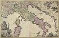
Novissima et accuratissima totius Italiae Corsicae et Sardiniae descriptio
1 : 1600000 correcta mu[l]tis aucta et in lucem edita per Gerardum Valk Amst. Bat. Luggert van Anse schulp. ; [bij het vignet:] Ph. Tideman inventor ; G. v. Gouwen fec. Amst. Bat. : per Gerardum Valk