Maps of Balkan Pen.

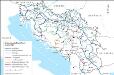
[XVIII], uit: Geognostische Karte des Oesterreichischen Kaiserstaates mit einem grossen Theile Deutschland's u. Italien / hauptsachlich nach ... Haidinger's geognostischer Karte dieses Staates bearb. von Josef Scheda
1 : 3000000 titelvariant: General-Karte von Europa in 25 Blättern; Annotatie: Bijlage bij: General-Karte von Europa in 25 Blättern. - 1:2.592.000. - 1845-1847 Scheda, Joseph Wien : K.K. Militär. Geografisch. Institut
Illyricvm Antiqvvm Eius que disterminatae Provinciae sub Dominatu Romano
1 : 11000000 Mollova mapová sbírka Clüver, Philipp Fuhrmann, Mathias
Die unterentwickelten Gemeinden in Jugoslwaien (schraffiert gekennzeichnet)
Jugoslawien Wirtschaftsentwicklung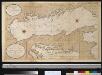
Nette afteekening van de Golf van Venetia vertoonende alle desselfs haavenen reede en baije in grood besteck
Italy Gerard van Keulen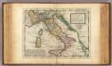
Italy.
1 : 5000000 Moll, Herman, d. 1732
Jugoslávie

NOVA | ITALIÆ | DELINEATIO
[Amsterdam : Joan Blaeu]
Nova Italiae Delineatio [Karte], in: Novus Atlas, das ist, Weltbeschreibung, Bd. 3, S. 10.
1 Karte aus Atlas Blaeu, Joan Blaeu, Willem Janszoon
Europaeische Türkey, Griechenland und die Jonischen Inseln

Handkarte des Jugoslawischen Reiches
1 : 1500000 Evropa jihovýchodní Ed. Hölzel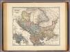
Pannonia, Illyricum, Dacia, Moesia, Thracia, Macedonia, Epirus.
1 : 4000000 Menke, Th.
Italia Nuovamente piu perfetta che mai per inanzi posta in luce, scolpita et con le suoi figure vivamente rappresentate [Karte], in: Novus atlas absolutissimus, Bd. 5, S. 11.
1 Karte aus Atlas Janssonius Offizin
Le golfe de Venise
1 Karte : Kupferdruck ; 51 x 58 cm Fer; Starckman chez l'auteur dans l'isle du Palais sur le quay de l'Orloge a la Sphere Royale
Italia Nuovamente piu perfetta che mai per inanzi posta in luce, scolpita et con le suoi figure vivamente rappresentate [Karte], in: Gerardi Mercatoris et I. Hondii Newer Atlas, oder, Grosses Weltbuch, Bd. 2, S. 218.
1 Karte aus Atlas Mercator, Gerhard und Hondius, Jodocus Jansson, Jan
Albanien mit Umgebung
Albanien Péch, Béla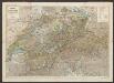
Nova Italiae Delineatio [Karte], in: Le théâtre du monde, ou, Nouvel atlas contenant les chartes et descriptions de tous les païs de la terre, Bd. 3, S. 8.
1 Karte aus Atlas Blaeu, Willem Janszoon und Blaeu, Joan Blaeu, Willem Janszoon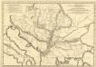
Theatrum Antiqvitatum Romanarum in Hungaria: sive Mappa Geographica Regionum Danubio Circumjacentium, Pannoniarum, Daciarum, Mysiar: Etc. in Qvibus Antiqvitates Romanae Svis Singulae Figuris in Hoc Tomo Descriptae Reperiuntur
1 : 4700000 Mollova mapová sbírka Marsili, Luigi Ferdinando
Le pays des Serbes, des Croates et des Slovenes
Jugoslawien Physische Geografie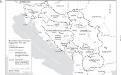
Staatenbildung im ehemaligen Jugoslawien, 1991 - 2008
1 : 2500000 Jugoslawien Auflösung, Staatenbildung Clewing, Konrad ; John, Holger W.
Nova Italiae Delineatio [Karte], in: Theatrum orbis terrarum, sive, Atlas novus, Bd. 3, S. 10.
1 Karte aus Atlas Blaeu, Joan Blaeu, Willem Janszoon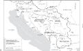
Jugoslawien nach dem Zweiten Weltkrieg (bis 1991) mit Republiken und Autonomen Provinzen
1 : 2500000 Jugoslawien Clewing, Konrad ; John, Holger W.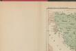
Les Serbes, les Croates et les Slovènes parmi les nations-voisines
Serbien Kroatien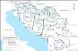
Eisenbahnnetz und Aufteilung der Adriaküste in Zonen (nach Vasković)
1 : 2500000 Jugoslawien Eisenbahnnetz Kežić, Danijel ; John, Holger W.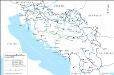
Das jugoslawische Eisenbahnnetz im Jahre 1918
1 : 2500000 Jugoslawien Eisenbahnnetz Kežić, Danijel ; John, Holger W.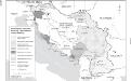
Besetzung und territoriale Aufteilung Jugoslawiens im Zweiten Weltkrieg
1 : 2500000 Jugoslawien Besetzung, Weltkrieg <1939-1945> Clewing, Konrad ; John, Holger W.
Carte de geographie des differents etats de la republique de Venise, l'abregé de son gouvernement politique et ecclesiastique, et les etats ou elle a porté la gloire de ses armes
1 : 4300000 Benátky-oblast (Itálie) Chatelain, Henri-Abraham Chatelain
Das jugoslawische Eisenbahnnetz im Jahre 1969
1 : 2500000 Jugoslawien Eisenbahnnetz Kežić, Danijel ; John, Holger W.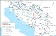
Eisenbahnnetz und Adria-Bahn-Projekte 1922
1 : 2500000 Jugoslawien Eisenbahnnetz Kežić, Danijel ; John, Holger W.
![[XVIII], uit: Geognostische Karte des Oesterreichischen Kaiserstaates mit einem grossen Theile Deutschland's u. Italien / hauptsachlich nach ... Haidinger's geognostischer Karte dieses Staates bearb. von Josef Scheda](https://images-2.georeferencer.com/images/iiif/298504559250/full/,300/0/native.jpg)

