Maps of Italy

Nova Italiae Delineatio [Karte], in: Novus Atlas, das ist, Weltbeschreibung, Bd. 3, S. 10.
1 Karte aus Atlas Blaeu, Joan Blaeu, Willem Janszoon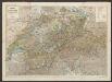
Nova Italiae Delineatio [Karte], in: Le théâtre du monde, ou, Nouvel atlas contenant les chartes et descriptions de tous les païs de la terre, Bd. 3, S. 8.
1 Karte aus Atlas Blaeu, Willem Janszoon und Blaeu, Joan Blaeu, Willem Janszoon
NOVA | ITALIÆ | DELINEATIO
[Amsterdam : Joan Blaeu]
Nova Italiae Delineatio [Karte], in: Theatrum orbis terrarum, sive, Atlas novus, Bd. 3, S. 10.
1 Karte aus Atlas Blaeu, Joan Blaeu, Willem Janszoon
Italia Nuovamente piu perfetta che mai per inanzi posta in luce, scolpita et con le suoi figure vivamente rappresentate [Karte], in: Gerardi Mercatoris et I. Hondii Newer Atlas, oder, Grosses Weltbuch, Bd. 2, S. 218.
1 Karte aus Atlas Mercator, Gerhard und Hondius, Jodocus Jansson, Jan
Italia Nuovamente piu perfetta che mai per inanzi posta in luce, scolpita et con le suoi figure vivamente rappresentate [Karte], in: Novus atlas absolutissimus, Bd. 5, S. 11.
1 Karte aus Atlas Janssonius Offizin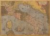
Italiae Novissima Descriptio [Karte], in: Theatrum orbis terrarum, S. 79.
1 Karte aus Atlas Ortelius, Abraham
[27][27]Novissima et accuratissima totius Italiae, Corsicae et Sardiniae descriptio, uit: Atlas sive Descriptio terrarum orbis
Annotatie: Gedigitaliseerde versie. Amsterdam. Heiloo : Picturae (vervaardiger), 2015. tiff-bestand. Gedigitaliseerd: 07-01-2015; Origineel: Universiteitsbibliotheek Vrije Universiteit (XL.05127.-) ; Netherlands; Titelpagina ontbreekt Wit, Frederik de Amsterdam : Frederick de Wit
Théâtre des Victoires de l'Armée d'Italie aux Ordres Du Général Buonaparte
Longchamps, Jacques François des; Blondeau, A. N. Pointeau
Italia XIX. Nova Tabula. [Karte], in: Claud. Ptolemaeus. Geographia lat. cum mappis [...], S. 419.
1 Karte aus Atlas Münster, Sebastian [und Ptolemaeus, Claudius]
Italiae Antiquae Nova Delinatio. [Karte], in: Novus atlas absolutissimus, Bd. 5, S. 8.
1 Karte aus Atlas Janssonius Offizin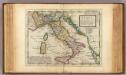
Italy.
1 : 5000000 Moll, Herman, d. 1732
Prussian States.
1 : 5200000 Arrowsmith, Aaron; Lewis, Samuel
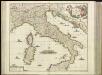
L'Italie distinguée suivant l'estendüe de tous les Estats, Royaumes, Republiques, Duchés, Pricipautés qui la partagent presentement [Karte], in: Atlas nouveau, contenant toutes les parties du monde [...], Bd. 2, S. 121.
1 Karte aus Atlas Sanson, Nicolas Jaillot, Alexis Hubert und Mortier, Pieter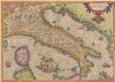
Italiae Novissima Descriptio [Karte], in: Theatrum orbis terrarum, S. 189.
1 Karte aus Atlas Ortelius, Abraham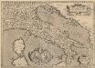
Italiae Veteris Specimen. [Karte], in: Theatrum orbis terrarum, S. 487.
1 Karte aus Atlas Ortelius, Abraham Vrients, Jan Baptista
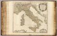
L'Italie.
1 : 2500000 Robert de Vaugondy, Gilles, 1688-1766
Italien
Hand-Atlas über alle Theile der Erde nach dem neuesten Zustande und über das Weltgebäude Stieler, Adolf bei Justus Perthes
Italien
Hand-Atlas über alle Theile der Erde nach dem neuesten Zustande und über das Weltgebäude Stieler, Adolf bei Justus Perthes
Tabula Europae V. [Karte], in: Geographia universalis vetus et nova complectens Claudii Ptolemaei Alexandrini enarrationis libros VIII, S. 234.
1 Karte aus Atlas Münster, Sebastian [und Ptolemaeus, Claudius]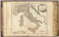
Italia Antiqua, Sicilia, Sardinia, et Corsica.
1 : 2500000 Sanson, Nicolas, 1600-1667
Italien.
1 : 3700000 Petermann, A.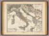
Italia, Gallia cisalpina, Sicilia, Sardinia, Corsica ab adventu Gallorum usque ad bellum Marsicum.
1 : 3900000 Menke, Th.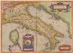
Italiae Veteris Specimen. [Karte], in: Theatrum orbis terrarum, S. 386.
1 Karte aus Atlas Ortelius, Abraham
Italien
Hand-Atlas über alle Theile der Erde und über das Weltgebäude Stieler, Adolf Justus Perthes

Jtalien
Stieler's Hand-Atlas Stieler, Adolf bei Justus Perthes
![Nova Italiae Delineatio [Karte], in: Novus Atlas, das ist, Weltbeschreibung, Bd. 3, S. 10.](https://images-2.georeferencer.com/images/iiif/120768731731/full/,300/0/native.jpg)

