Maps of Italy

Italien
Handatlas über alle Theile der Erde und über das Weltgebäude Stieler, Adolf Justus Perthes
Italien
Hand-Atlas über alle Theile der Erde und über das Weltgebäude Stieler, Adolf Justus Perthes
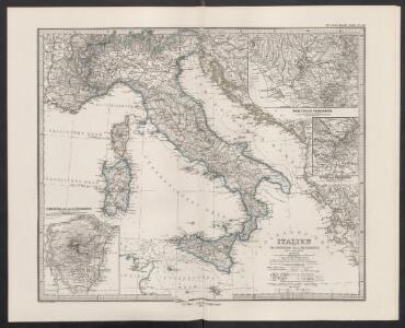
Italien.
1 : 3700000 Petermann, A.
Map of Italy.
1 : 6050000 Bowen, Emanuel
L'Italie distinguée suivant l'estendüe de tous les Estats, Royaumes, Republiques, Duchés, Pricipautés qui la partagent presentement [Karte], in: Atlas nouveau, contenant toutes les parties du monde [...], Bd. 2, S. 121.
1 Karte aus Atlas Sanson, Nicolas Jaillot, Alexis Hubert und Mortier, Pieter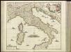
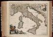
[27][27]Novissima et accuratissima totius Italiae, Corsicae et Sardiniae descriptio, uit: Atlas sive Descriptio terrarum orbis
Annotatie: Gedigitaliseerde versie. Amsterdam. Heiloo : Picturae (vervaardiger), 2015. tiff-bestand. Gedigitaliseerd: 07-01-2015; Origineel: Universiteitsbibliotheek Vrije Universiteit (XL.05127.-) ; Netherlands; Titelpagina ontbreekt Wit, Frederik de Amsterdam : Frederick de Wit
Italien
Adolf Stieler's Handatlas über alle Theile der Erde und über das Weltgebäude Stieler, Adolf Justus Perthes
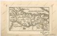
Tabula Moderna Et Nova Italie Ac Sicilie [Karte], in: Claudii Ptolemei viri Alexandrini mathematice discipline philosophi doctissimi geographie opus [...], S. 254.
1 Karte aus Atlas Waldseemüller, Martin [und Ptolemaeus, Claudius] Übelin, Georg
Nieuwe kaart van geheel Italien, volgens de laatste verbeteringen
1 : 7500000 [S.l.] : [s.n.]


Charte von Italien : nach der dermaligen Verfassung, auch mit dessen alten und neuen Grenzen nach den bewährtesten Hülfsmitteln neu entworfen und gezeichnet = Carta d'Italia secondo la presento Costituzione
1 : 2400000 Augsburg : Walch
Italia XIIII. Nova Tabula [Karte], in: Claud. Ptolemaeus. Geographia lat. cum mappis [...], S. 395.
1 Karte aus Atlas Münster, Sebastian [und Ptolemaeus, Claudius]
Totius Italiae Tabula. [Karte], in: Novus atlas absolutissimus, Bd. 5, S. 14.
1 Karte aus Atlas Janssonius Offizin
Italien
Hand-Atlas über alle Theile der Erde nach dem neuesten Zustande und über das Weltgebäude Stieler, Adolf bei Justus Perthes
ITALIA cum Insulis dependentib[us]
1 : 8800000 Itálie
Totius Italiæ tabula / per Nicolaum Visscher
1 : 3000000 Annotatie: Cum privilegio Ordinum Holland[iæ] et West-Fris[iæ]; Met opdracht van N. Visscher aan Cosmo III van Toscane; Origineel is Blad 151 in atlas factice; Annotatie geografische gegevens: Met 3 schaalstokken; Legenda Nicolaes Jansz. Visscher jr. 1649-1702 [Amsterdam : N. Visscher]
Italia XIIII. Nova Tabula [Karte], in: Geographia universalis vetus et nova complectens Claudii Ptolemaei Alexandrini enarrationis libros VIII, S. 341.
1 Karte aus Atlas Münster, Sebastian [und Ptolemaeus, Claudius]
Italien
Hand-Atlas über alle Theile der Erde nach dem neuesten Zustande und über das Weltgebäude Stieler, Adolf bei Justus Perthes
L'Italie, dressée sur les observations de Mrs. de l'Academie Royale des Sciences, sur celles du R. P. Riccioli de la compagnie de Jesus, et autres astronomes du pays, et sur plusieurs autres memoires
1 : 2500000 par G. De l'Isle A Amsterdam : chez R. & J. Ottens
Italien
E. von Sydow's Schul-Atlas in sechs und dreissig Karten Sydow, Emil von bei Justus Perthes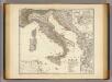
Italia, Gallia citerior, Illyricum, Sicilia, Sardinia, Corsica.
1 : 3900000 Menke, Th.
Théâtre des Victoires de l'Armée d'Italie aux Ordres Du Général Buonaparte
Longchamps, Jacques François des; Blondeau, A. N. Pointeau
Tabula Europae VI. [Karte], in: Claud. Ptolemaeus. Geographia lat. cum mappis [...], S. 269.
1 Karte aus Atlas Münster, Sebastian [und Ptolemaeus, Claudius]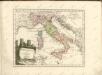

Homannův atlas světa
1 : 2100000
Italia XIX. Nova Tabula. [Karte], in: Claud. Ptolemaeus. Geographia lat. cum mappis [...], S. 419.
1 Karte aus Atlas Münster, Sebastian [und Ptolemaeus, Claudius]