Maps of Italy

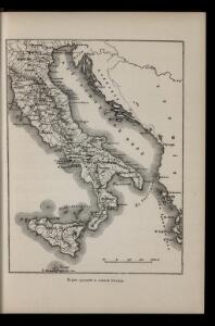
Karta srednej i južnoj Italīi
Italien Seeschlacht
Charte von Italien: Wie es vor der französischen Revolution war und wie es jezt ist
1 : 4600000 Landes-Industrie-Comptoir
Charte von Italien : nach der dermaligen Verfassung, auch mit dessen alten und neuen Grenzen nach den bewährtesten Hülfsmitteln neu entworfen und gezeichnet = Carta d'Italia secondo la presento Costituzione
1 : 2400000 Augsburg : Walch
Italien
Adolf Stieler's Handatlas über alle Theile der Erde und über das Weltgebäude Stieler, Adolf Justus Perthes
Italien.
1 : 3700000 Petermann, A.
Nieuwe kaart van geheel Italien, volgens de laatste verbeteringen
1 : 7500000 [S.l.] : [s.n.]
Italy.
1 : 3000000 Cary, John, ca. 1754-1835

L'Italie, dressée sur les observations de Mrs. de l'Academie Royale des Sciences, sur celles du R. P. Riccioli de la compagnie de Jesus, et autres astronomes du pays, et sur plusieurs autres memoires
1 : 2500000 par G. De l'Isle A Amsterdam : chez R. & J. Ottens
Map of Italy.
1 : 6050000 Bowen, Emanuel
Italien
Hand-Atlas über alle Theile der Erde und über das Weltgebäude Stieler, Adolf Justus Perthes
Italien
Handatlas über alle Theile der Erde und über das Weltgebäude Stieler, Adolf Justus Perthes
Italien
E. von Sydow's Schul-Atlas in sechs und dreissig Karten Sydow, Emil von bei Justus Perthes
Italia, Gallia citerior, Illyricum, Sicilia, Sardinia, Corsica.
1 : 3900000 Menke, Th.
Italia, Gallia cisalpina, Sicilia, Sardinia, Corsica ab adventu Gallorum usque ad bellum Marsicum.
1 : 3900000 Menke, Th.
Totius Italiae Tabula. [Karte], in: Novus atlas absolutissimus, Bd. 5, S. 14.
1 Karte aus Atlas Janssonius Offizin
Italien
Hand-Atlas über alle Theile der Erde nach dem neuesten Zustande und über das Weltgebäude Stieler, Adolf bei Justus Perthes
Jtalien
Stieler's Hand-Atlas Stieler, Adolf bei Justus Perthes
Italiae antiquae tabula geographica
1 : 5410000 Itálie Berra, Marco Marco Berra
Italien
Hand-Atlas über alle Theile der Erde nach dem neuesten Zustande und über das Weltgebäude Stieler, Adolf bei Justus Perthes
Kaart van Italië c.a.
1 : 3500000 titelvariant: Italië; Annotatie: Titel rechtsonder: Italië [S.l. : s.n.]
Statuum totius Italiae
1 : 2900000 Mollova mapová sbírka Homann, Johann Baptist Homann, Johann Baptista

Italia Antiqua, Sicilia, Sardinia, et Corsica.
1 : 2500000 Sanson, Nicolas, 1600-1667
Italiae antiquae tabula geographica cum Insulis adjacentibus

Illyricvm Antiqvvm Eius que disterminatae Provinciae sub Dominatu Romano
1 : 11000000 Mollova mapová sbírka Clüver, Philipp Fuhrmann, Mathias
L'Italie
1 Karte : Kupferdruck ; 48 x 61 cm Le Rouge Le Rouge rue des grands Augustins vis a vis le panier Fleury