Maps of Sogn og Fjordane

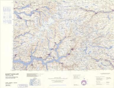
Statistikk 43-10-2: Bosettingskart over Årdal. Blad 10
1 : 250000 Statistisk Sentralbyrå
Statistikk 43-10- Bosettingskart over Årdal. Blad 10
1 : 250000 Statistisk Sentralbyrå
Kartblad 124: Situations-Kart over Grændsen mellom 1ste og 2det Bergenhuusiske Regiment
Niels Thodal
Spesielle kart: Tyngdeanomalikart, Ã...rdal
1 : 250000 NGO
Årdal
1 : 250000 Army map service
Trigonometrisk grunnlag, vedlegg 68-8
1 : 250000
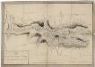
Kartblad 122: Situasion af de Bergenhuusske Regimenters Grændser udi Indre Sogn saaledes som samme vilde blive efter den af det Første Bergenhuusiske Regiment udkastede Plan

Norge 55-17: Accurat landcaart over Norges Rige anden Part
1 : 300000 G. Bordin
Jostedalsbræen med tilgrænsende strøk

Trigonometrisk grunnlag, Squelet-Cart 57: Trigonometrisk Kart
1 : 200000 H. Gill
Trigonometrisk grunnlag, Squelet-Cart 55: kart over de i Sommeren 1859 bestemte Punkter
1 : 200000 H. Gill
Museumskart 217-56: Specialkart over Sognefjorden
1 : 100000 G. Dellinger Den Geografiske Opmaaling
LE NÉVÉ DE JUSTEDAL ET SES ALENTOURS
M. Lyng's lith. Anst. Christiania
Spesielle kart 123-6: Kart over Drammensvassdraget
1 : 100000 Toralf à ̃yen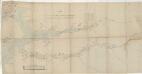
Kartblad 138: Vei-Cart over det Leirdalske Jæger Compagnie
Amund Wiegh
Kartblad 125: Carte over det Tiugumske Compagnie District

24C 12; 24C 8 (1/2); 24D 5 (1/2); 24D 9; 24D 10 (1/4); 30A 4; 30A 8 (3/4); 30A 12 (1/2); 30B 1; 30B 2 (1/2); 30B 5; 30B 6 (1/2); 30B 9; 30B 10; 30B 11
1 : 100000 Harald Nicolai Storm Wergeland
30D 1; 30D 2; 30D 3; 30D 5; 30D 6; 30D 7; 30D 9; 30D 10; 30D 11; 30C 4; 30C 7; 30C 8; 30C 11; 30C 12; 30B 10; 36A 3; 36A 4; 36B 1; 36B 2
1 : 100000 Harald Nicolai Storm Wergeland
Spesielle kart 103-5: Flötningskart over Glommens vassdrag
1 : 1000 Einar Sigurd Ween
E31-7, E31-11
1 : 100000 Toralf Øyen | Gunvald Hagene
Norge 55-13: Accurat landcaart over Norges Rige anden Part
1 : 3000000 G. Bordin
30B 9; 30B 10; 30B 11; 30C 8; 30C 12; 30D 1; 30D 2; 30D 3; 30D 5; 30D 6; 30D 7; 30D 9; 30D 10; 30D 11
1 : 100000 Johan Nicolai Hertzberg
30B 9 30B 10 30B 11 30C 8 30C 12 30D 1 30D 2 30D 3 30D 5 30D 6 30D 7 30D 9 30D 10 30D 11
1 : 100000 Johan Nicolai Hertzberg
30B 9; 30B 10; 30B 11; 30C 8; 30C 12; 30D 1; 30D 2; 30D 3; 30D 5; 30D 6; 30D 7; 30D 9; 30D 10; 30D 11
1 : 100000 Johan Nicolai Hertzberg
30D Galdhøpiggen
1 : 100000 H. N. Bergh | F. Eriksen | Johan Nordhagen | H. T. Bjørnstad
24A 10; 24A 11; 24C 2; 24C 3; 24C 6; 24C 7; 24C 8; 24C 10; 24C 11; 24C 12
1 : 100000 Bernt Lund
30B 9 30B 10 30B 11 30C 8 30C 12 30D 1 30D 2 30D 3 30D 5 30D 6 30D 7 30D 9 30D 10 30D 11
1 : 100000 Johan Nicolai Hertzberg
30B 9; 30B 10; 30B 11; 30C 8; 30C 12; 30D 1; 30D 2; 30D 3; 30D 5; 30D 6; 30D 7; 30D 9; 30D 10; 30D 11
1 : 100000 Johan Nicolai Hertzberg
29D 1; 29D 5; 29D 6; 29D 9; 29D 10; 29D 11
1 : 100000 Karsten Lorange