Maps of Luster

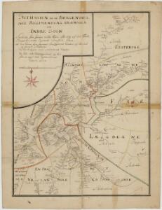
Kartblad 122: Situasion af de Bergenhuusske Regimenters Grændser udi Indre Sogn saaledes som samme vilde blive efter den af det Første Bergenhuusiske Regiment udkastede Plan

Statistikk 43-10- Bosettingskart over Årdal. Blad 10
1 : 250000 Statistisk Sentralbyrå
Spesielle kart: Tyngdeanomalikart, Ã...rdal
1 : 250000 NGO
Trigonometrisk grunnlag, vedlegg 68-8
1 : 250000
Årdal
1 : 250000 Army map service
Jostedalsbræen med tilgrænsende strøk

Museumskart 217-56: Specialkart over Sognefjorden
1 : 100000 G. Dellinger Den Geografiske Opmaaling
LE NÉVÉ DE JUSTEDAL ET SES ALENTOURS
M. Lyng's lith. Anst. Christiania
Kartblad 125: Carte over det Tiugumske Compagnie District

Kartblad 126: Wej- og Situations_cart over det Tjugumske Compagnie District
Gerhard Heiberg Daae
Kartblad 132-2: Situation af det Urlandske Compagnie District; versjon 2
Leitzner
Kartblad 132- Situation af det Urlandske Compagnie District; versjon 1
Leitzner
Portefølje nr 36
1 : 100000 H. Lund
Norge 55-13: Accurat landcaart over Norges Rige anden Part
1 : 3000000 G. Bordin
Spesielle kart 14: Kart over Fjeldovergangen for en Jernbanelinie mellem Vos og Hallingdal
1 : 100000
29D 1; 29D 5; 29D 6; 29D 9; 29D 10; 29D 11
1 : 100000 Karsten Lorange
C32 vest Aurlandsdalen
1 : 100000
C31 aust Sogndal
1 : 100000
29B Sogndal
1 : 100000 E. Heiberg | H. T. Bjørnstad
29B Sogndal
1 : 100000 H. T. Bjørnstad | E. Heiberg
29B Sogndal
1 : 100000 H. T. Bjørnstad
C32 aust Flåmsdalen
1 : 100000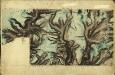
30C 5; 30C 6; 30C 7; 30C 9; 30C 10; 30C 11; 29D 12
1 : 100000 Henrik Lund
C31 aust Sogndal
1 : 100000
C32 vest Vossestrand
1 : 100000
C32 aust Flåmsdalen
1 : 100000
C32 aust Flåmsdalen
1 : 100000
C32 vest Aurlandsdalen
1 : 100000
D31 vest Lærdal
1 : 100000