Maps of Møre og Romsdal

Spesielle kart nr 44: Sell - Opdal - Støren og Opdal - Sundal - Molde
1 : 400000
Museumskart 97: Karta öfver den nordvestra kusten af Norrige ifrån Stadtland til Trondhjem
1 : 100000 Gustaf Klint
Geologisk kart 114: Glasialgeologisk kart over sørlige Midt-Norge
1 : 500000 J. L. Sollid | L. Sørbel Norsk geografisk tidsskrift
Norge 32b: Cituations Carte over en vis Bestreckning nemblig fra Trundhiem og til Opdalen
1 : 300000 Varendorff
Dioecesis Trundhemiensis Pars Australis. [Karte], in: Novus atlas absolutissimus, Bd. 1, S. 36.
1 Karte aus Atlas Janssonius Offizin
Norge 32e: Cituations Carte over en vis Bestreckning nemblig fra Trundhiem og til Opdalen
1 : 300000
DIOECESIS | TRVNDHEMIENSIS | PARS AVSTRALIS.
[Amsterdam : Joan Blaeu]
Norge 32d: Cituations Carte over en vis Bestreckning nemblig fra Trundhiem og til Opdalen
1 : 300000 Stuarts
XI
1 : 400000 N. Franck
Kartblad 107: Situations Cart over det 2det Trondhiemske Regiments District
J. C. R.
Spesielle kart: Tyngdeanomalikart, Ã...lesund
1 : 250000 NGO
Norge 32c: Cituations Carte over en vis Bestreckning nemblig fra Trundhiem og til Opdalen
1 : 300000 J. H. Emahusen
XI
1 : 400000 N. Franck
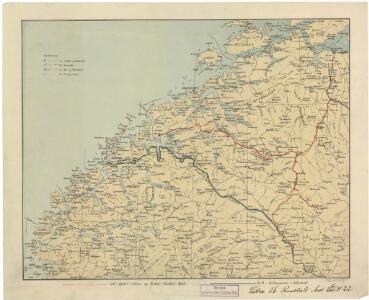
Bl. XI Molde
1 : 300000
Museumskart 103: Situations-Cart over den Norske Søekyst fra Tronhiems Bye til Bergenhus-stift
1 : 50000 Niels Andreas Wibe
Norge 32a: Cituations Carte over en vis Bestreckning nemblig fra Trundhiem og til Opdalen
1 : 300000 G. M. D.
Museumskart 217-68: Kart over Havbankerne Langs den Norske Kyst fra Stadt til Smølen
1 : 200000 M. Lyng Den Geografiske Opmaaling
Geologisk kart over det Söndenfjeldske Norge
1 : 400000 Nordwest-Blatt Kjerulf, Theodor ; Dahll, Tellef Carl Schwenzens
Norge 55-14: Accurat landcaart over Norges Rige anden Part
1 : 3000000 G. Bordin
Statistikk 38-6: Bosettingskart over Møre og Romsdal, Sogn og Fjordane og Oppland. Blad 6
1 : 400000 Statistisk Sentralbyrå
Statistikk 38-8: Bosettingskart over Norge. Blad 8
Statistisk Sentralbyrå
Spesielle kart 122-6: Postkart over Norge
1 : 400000 Toralf à ̃yen
XIV
1 : 400000 K. Petersen
Statistikk 43-15- Bosettingskart over Kristiansund. Blad 15
1 : 250000 Statistisk Sentralbyrå
Spesielle kart 122-8: Postkart over Norge
1 : 400000 Toralf à ̃yen
Statistikk 43-15-2: Bosettingskart over Kristiansund. Blad 15
1 : 250000 Statistisk Sentralbyrå
XIV
1 : 400000 K. Petersen
Trigonometrisk grunnlag, Squelet-Cart 58: Oversigtskart over de i Aarene 1864 og 1865 bestemte Punkter
1 : 350000 F. Sejersted
X
1 : 400000 N. Franck