Maps of Sør-Trøndelag

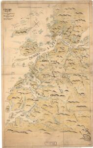
Norge 32b: Cituations Carte over en vis Bestreckning nemblig fra Trundhiem og til Opdalen
1 : 300000 Varendorff
Museumskart 174: Fra "Hoeck van Horrel til Momendal"
1 : 500000 Pieter Goos
XIV
1 : 400000 K. Petersen
Dioecesis Trundhemiensis Pars Australis. [Karte], in: Novus atlas absolutissimus, Bd. 1, S. 36.
1 Karte aus Atlas Janssonius Offizin
Norge 32a: Cituations Carte over en vis Bestreckning nemblig fra Trundhiem og til Opdalen
1 : 300000 G. M. D.
DIOECESIS | TRVNDHEMIENSIS | PARS AVSTRALIS.
[Amsterdam : Joan Blaeu]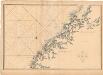
Museumskart 97: Karta öfver den nordvestra kusten af Norrige ifrån Stadtland til Trondhjem
1 : 100000 Gustaf Klint
Museumskart 102: Situations Kaart over En Deel af den Norske Kyst, Todalsfjorden-Hanøya
1 : 40000
Spesielle kart nr 44: Sell - Opdal - Støren og Opdal - Sundal - Molde
1 : 400000
XIV
1 : 400000 K. Petersen
Norge 32e: Cituations Carte over en vis Bestreckning nemblig fra Trundhiem og til Opdalen
1 : 300000
Museumskart 103: Situations-Cart over den Norske Søekyst fra Tronhiems Bye til Bergenhus-stift
1 : 50000 Niels Andreas Wibe
Norge 32d: Cituations Carte over en vis Bestreckning nemblig fra Trundhiem og til Opdalen
1 : 300000 Stuarts
XIV
1 : 400000 K. Petersen
Norge 32c: Cituations Carte over en vis Bestreckning nemblig fra Trundhiem og til Opdalen
1 : 300000 J. H. Emahusen
Kartblad 107: Situations Cart over det 2det Trondhiemske Regiments District
J. C. R.
XI
1 : 400000 N. Franck
Bl. XI Molde
1 : 300000
XI
1 : 400000 N. Franck
Statistikk 43-15- Bosettingskart over Kristiansund. Blad 15
1 : 250000 Statistisk Sentralbyrå
Statistikk 38-7: Bosettingskart over Norge. Blad 7
Statistisk Sentralbyrå
Kartblad 167: Carte over de Districter af 1ste og 3die Trondhiemske Regimenter; hvorinden de 3de nordenfieldske Skieløbercompagnier langs græntzerne af bemeldte 2de Regimenter; ved holden Commission den 17de october 1747; bleve lagte som bequæmest choiseret til Landets Defence
J. Emahusen | Koefoed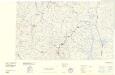
Statistikk 43-14-1: Bosettingskart over Røros. Blad14
1 : 250000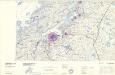
Statistikk 43-16- Bosettingskart over Bergen. Blad 16
1 : 250000 Statistisk Sentralbyrå
Statistikk 38-8: Bosettingskart over Norge. Blad 8
Statistisk Sentralbyrå
Spesielle kart 122-7: Postkart over Norge
1 : 400000 Toralf à ̃yen
Statistikk 43-16-2: Bosettingskart over Bergen. Blad 16
1 : 250000 Statistisk Sentralbyrå
Spesielle kart 122-8: Postkart over Norge
1 : 400000 Toralf à ̃yen
Museumskart 217-68: Kart over Havbankerne Langs den Norske Kyst fra Stadt til Smølen
1 : 200000 M. Lyng Den Geografiske Opmaaling