Maps of Birkenes

5C 3
1 : 50000 Hilmar Krogh Borchgrevink
E39-1, E39-7
1 : 50000 Adler Gleditsch
5C 2 5C 3 5C 6 5C 7
1 : 50000 Paul Hansen Birch Brun
5C 4
1 : 50000 Harald Ingvar Johannessen
D39 aust Evje
1 : 100000
1511-1 Lillesand
1 : 50000 Norges Geografiske Oppmåling
1511-1 Lillesand
1 : 50000 Statens kartverk
D39-6
1 : 50000 Adler Gleditsch | Johannes Oliver Smith
D39-5
1 : 50000 Per Tang | Einar Halle
1511-1 Lillesand
1 : 50000 Norges Geografiske Oppmåling
D39-5, D39-11
1 : 50000 Thor Sire
D39-12
1 : 50000 Adler Gleditsch
1512-2 Mykland
1 : 50000 Statens kartverk
1511-1 Lillesand
1 : 50000 Statens kartverk
1511-1 Lillesand
1 : 50000 Statens kartverk
1511-1 Lillesand
1 : 50000 Norges Geografiske Oppmåling
E39 vest Froland
1 : 100000
E39-7
1 : 50000 Hjalmar Skaar
E39 vest Froland
1 : 100000
E39 vest Froland
1 : 100000
E39 vest Froland
1 : 100000
D39-11
1 : 50000 Adler Gleditsch
E39-8
1 : 50000 N. Houge | Toralf Øyen
Portefølje nr 3
1 : 100000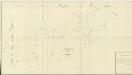
Trigonometrisk grunnlag, Squelet-Cart 18-2: Kysten fra Tromøy til Christiansand
Niels Andreas Wibe | B. Aubert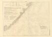
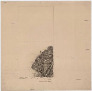
Museumskart 217-20: Kart over Den Norske Kyst fra Jomfruland og Kragerø til Christiansand
1 : 50000 Schie | C. Diriks | H. Wille Opmaalings Directionen
Geologiske kart 121-V2: Kart med magnetisk totalfelt. Arendal
1 : 250000 Norges geologiske undersøkelse
Trigonometrisk grunnlag, Squelet-Cart 46: Kart for 1850
C. Bassøe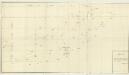
Trigonometrisk grunnlag, Squelet-Cart 18- Kysten fra Tromøy til Christiansand
Niels Andreas Wibe | B. Aubert