Maps of Drangedal

Trigonometrisk grunnlag, Squelet-Cart 65-1

Geologiske kart 121-V2: Kart med magnetisk totalfelt. Arendal
1 : 250000 Norges geologiske undersøkelse
Statistikk 43-2- Bosettingskart over Arendal. Blad 1
1 : 250000 Statistisk Sentralbyrå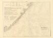
Museumskart 217-20: Kart over Den Norske Kyst fra Jomfruland og Kragerø til Christiansand
1 : 50000 Schie | C. Diriks | H. Wille Opmaalings Directionen
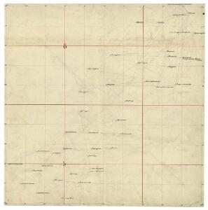
Trigonometrisk grunnlag, Squelet-Cart 42: Kart over de i sommeren 1847 av Lieut: F. Næser trigonometrisk bestemte punkter
F. Næser
Trigonometrisk grunnlag, Squelet-Cart 19-2: Kysten fra Kragerø til Tromøy
Niels Andreas Wibe | B. Aubert
Trigonometrisk grunnlag, Squelet-Cart 19- Kysten fra Kragerø til Tromøy
B. Aubert | Niels Andreas Wibe
Kartblad 149: Oculair Cart over det 1ste Nedenæsske Compagnie District
E. G. Jebe
Trigonometrisk grunnlag, Squelet-Cart 44: Kart for 1848
C. Bassøe
Museumskart 60c: Kart over strekningen Kristiansand-Risør
1 : 200000 Rasmus Iuel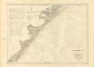
Museumskart 217-23: Kart over Den Norske Kyst fra Jomfruland og Kragerø til Arendal
1 : 50000 Fehr | Vibe | C. Diriks Opmaalings Directionen
Portefølje nr 7
1 : 100000 G. A. Sommerfeldt
Portefølje nr 7
1 : 100000 G. A. Sommerfeldt
Portefølje nr 8
1 : 100000 H. Gill
Portefølje nr 8
1 : 100000 H. Gill
5D Arendal
1 : 100000 Ole Engh | Solem
Kartblad 148: Wey-Cart over det Bambleske Herr Capitain von Pohlmans anfortroede Compagnie
H. L. Wamberg
Museumskart 59: Kart over strekningen Risør-Arendal
1 : 100000 Jens Sørensen
8A 8 8A 12 8B 5 8B 6 8B 9 8B 10 8C 4 8C 8 8C 12 8D 1 8D 2 8D 3 8D 5
1 : 100000 P. Paasche
Museumskart 18
1 : 50000 Rasmus Iuel
5D Arendal
1 : 100000 Carl Christian Olberg | Solem
5D Arendal
1 : 100000 Solem | Carl Christian Olberg
5D Arendal
1 : 100000
5D Arendal
1 : 100000 Solem | Carl Christian Olberg
5D Arendal
1 : 100000 Carl Christian Olberg | Solem
E39 vest Froland
1 : 100000
Kartblad 140: Vej-Kart over det 2det Nedenæsske Compagnie District
M. Kuur
E39 vest Froland
1 : 100000
E39 vest Froland
1 : 100000