Maps of Vest-Agder

Trigonometrisk grunnlag, Squelet-Cart 46: Kart for 1850
C. Bassøe
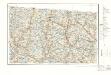
Kart over Lister og Mandals amt
1 : 200000 Norsko Gjessing, Soren Christian Geografiske opmaaling
Geologiske kart 121-F: Kart med magnetisk totalfelt. Mandal
1 : 250000 Norges geologiske undersøkelse
Trigonometrisk grunnlag, Squelet-Cart 18- Kysten fra Tromøy til Christiansand
Niels Andreas Wibe | B. Aubert
Trigonometrisk grunnlag, Squelet-Cart 47: Kart for 1851
C. S. Grimsgaard
Trigonometrisk grunnlag, Squelet-Cart 18-2: Kysten fra Tromøy til Christiansand
Niels Andreas Wibe | B. Aubert
Portefølje nr 6
1 : 100000
Portefølje nr 2
1 : 100000 H. Gill
Portefølje nr 2
1 : 100000 H. Gill
Portefølje nr 6
1 : 100000
Museumskart 217-2 Kart over Den Norske Kyst fra Christiansand til Ekersund
1 : 50000 H. Wille | Schie Opmaalings Directionen
5A Kristiansand
1 : 100000 C. Pedersen | Daniel Tønnesen
5A Kristiansand
1 : 100000 Daniel Tønnesen | H. C. Wanggård
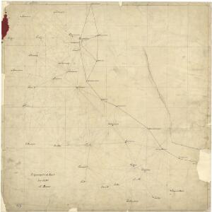
Kartblad 143-2: Geographiske Wej-Cart over det 2det Mandahlske Compagnie District; versjon 2

5A Kristiansand
1 : 100000
Kartblad 143- Geographiske Wej-Cart over det 2det Mandahlske Compagnie District; versjon 1

D39 aust Evje
1 : 100000
Geologisk kart 3-1b: Snitt over det Søndenfjeldske Norge
1 : 200000 P. Waage | H. Mohn | Tellef Dahll | A. S. Bachke
5A Kristiansand
1 : 100000 H. C. Wanggård | Daniel Tønnesen
5A Kristiansand
1 : 100000 C. Pedersen | Daniel Tønnesen
5A Kristiansand
1 : 100000 Daniel Tønnesen | H. C. Wanggård
5A Kristiansand
1 : 100000 Daniel Tønnesen | H. C. Wanggård
C39 aust Fjotland
1 : 100000
D39 aust Evje
1 : 100000
C39 aust Fjotland
1 : 100000
D38 aust Bygland
1 : 100000
D39 vest Bjelland
1 : 100000
D39 vest Bjelland
1 : 100000
4B Audnedal
1 : 100000 Hagen og Kornmann