Maps of Halsa

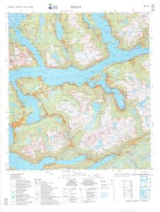
1421-3 Halsa
1 : 50000 Statens kartverk
1421-3 Halsa
1 : 50000 Norges Geografiske Oppmåling
1421-3 Halsa
1 : 50000 Statens kartverk
45B 3; 45B 4; 45B 7; 45B 8
1 : 50000 Fredrik Wille
45B 10
1 : 50000 Ole Hagbart Bertrand Norgrenn
Kartblad 108: Carte over det Surendalske Compagnie District
H. M. Arentz
45B 1; 45B 2; 45B 5; 45B 6
1 : 50000 Johan Iversen
1421-4 Skarsö
1 : 50000 Norges Geografiske Oppmåling
1421-4 Skardsöy
1 : 50000 Norges Geografiske Oppmåling
1421-4 Skardsøya
1 : 50000 Statens kartverk
1421-4 Skardsøya
1 : 50000 Statens kartverk
1420-4 Stangvik
1 : 50000 Statens kartverk
45B 11; 45B 12; 45D 3; 45D 4
1 : 50000 Fredrik Wille
41D 6; 41D 7; 41D 10; 41D 11
1 : 50000 Feiring
1420-4 Stangvik
1 : 50000 Statens kartverk
1420-4 Stangvik
1 : 50000 Norges Geografiske Oppmåling
1420-4 Stangvik
1 : 50000 Statens kartverk
Kartblad 112: Carte over det Wigsche-Nordmørsche Compagnie District
Johan Thomas Hornemann
Trigonometrisk grunnlag, Squelet-Cart 56: kart over de i Sommeren 1859 bestemte Punkter
A. Heiberg
Museumskart 100a: Speciel Kaart over en Deel af den Norske Kyst fra Christianssund til Bergens Stifts Grændse.
1 : 75000 Carl Frederik Grove | Niels Andreas Wibe
Kartblad 118: Vei-Kort over det Gangnatiske Compagnie District
Elias Nægler
1421-2 Vinjeöra
1 : 50000 Norges Geografiske Oppmåling
1321-2 Kristiansund
1 : 50000 Statens kartverk
41D 9
1 : 50000 Eiler Christian Holtermann
1421-2 Vinjeøra
1 : 50000 Statens kartverk
1421-2 Vinjeøra
1 : 50000 Norges Geografiske Oppmåling
1321-2 Kristiansund
1 : 50000 Norges Geografiske Oppmåling
41D 8; 41D 12; 42C 5; 42C 9
1 : 50000 Fredrik Wille
45B 9
1 : 50000