Maps of Aure

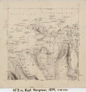
45B 10
1 : 50000 Ole Hagbart Bertrand Norgrenn
45D 2
1 : 50000 A. Holm
1421-4 Skardsøya
1 : 50000 Statens kartverk
1421-4 Skarsö
1 : 50000 Norges Geografiske Oppmåling
1421-4 Skardsøya
1 : 50000 Statens kartverk
1421-4 Skardsöy
1 : 50000 Norges Geografiske Oppmåling
1421-3 Halsa
1 : 50000 Norges Geografiske Oppmåling
1421-3 Halsa
1 : 50000 Statens kartverk
1421-3 Halsa
1 : 50000 Statens kartverk
45B 9
1 : 50000
45B 11; 45B 12; 45D 3; 45D 4
1 : 50000 Fredrik Wille
1421-4 Skardsøya
1 : 50000 Statens kartverk
1321-1 Smöla
1 : 50000 Norges Geografiske Oppmåling
45B 1; 45B 2; 45B 5; 45B 6
1 : 50000 Johan Iversen
Kartblad 112: Carte over det Wigsche-Nordmørsche Compagnie District
Johan Thomas Hornemann
Trigonometrisk grunnlag, Squelet-Cart 56: kart over de i Sommeren 1859 bestemte Punkter
A. Heiberg
Geologiske kart 121-J2: Kart med magnetisk totalfelt. Kristiansund
1 : 250000 Norges geologiske undersøkelse
Norge 55-14: Accurat landcaart over Norges Rige anden Part
1 : 3000000 G. Bordin
Trigonometrisk grunnlag, Squelet-Cart 65-15

Statistikk 43-15-2: Bosettingskart over Kristiansund. Blad 15
1 : 250000 Statistisk Sentralbyrå
Kartblad 107: Situations Cart over det 2det Trondhiemske Regiments District
J. C. R.
Statistikk 43-15- Bosettingskart over Kristiansund. Blad 15
1 : 250000 Statistisk Sentralbyrå
Norge 32c: Cituations Carte over en vis Bestreckning nemblig fra Trundhiem og til Opdalen
1 : 300000 J. H. Emahusen
XIV
1 : 400000 K. Petersen
Spesielle kart 122-8: Postkart over Norge
1 : 400000 Toralf à ̃yen
Statistikk 38-8: Bosettingskart over Norge. Blad 8
Statistisk Sentralbyrå
Norge 32d: Cituations Carte over en vis Bestreckning nemblig fra Trundhiem og til Opdalen
1 : 300000 Stuarts
XIV
1 : 400000 K. Petersen
Museumskart 103: Situations-Cart over den Norske Søekyst fra Tronhiems Bye til Bergenhus-stift
1 : 50000 Niels Andreas Wibe