Maps of Carpathian Mountains

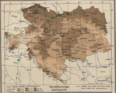
Österreich-Ungarn, Bevölkerungsdichtigkeit
Österreich-Ungarn Bevölkerungsdichte
Jährliche Regenmenge
Österreich-Ungarn Gebietsniederschlag
Wein und Tabak
Österreich-Ungarn Weinbau, Tabakanbau
Österreichisch-Ungarische Monarchie
Volksschul-Atlas über alle Teile der Erde Lange, Henry Druck und Verlag von Georg Westermann
Oesterreich-Ungarn
1 : 4900000 Österreich-Ungarn
Gewebe- und Glasindustrie
Österreich-Ungarn Textilindustrie, Glasindustrie
Mineralien
Österreich-Ungarn Mineralischer Rohstoff
Tatsächliche Zu- und Abnahme der anwesenden Bevölkerung in den politischen Bezirken der Reichsratsländer im Jahrzehnt 1901 – 1910
Österreich Bevölkerungsentwicklung
Oesterreichisch-Ungarische Monarchie
1 : 4600000 Österreich-Ungarn
Karte III: Nationalitätenkarte von Österreich-Ungarn
Österreich Ungarn Tschechische Republik Polen Österreich-Ungarn Ethnische Gruppe
Österreich-Ungarn, Religionen
Österreich-Ungarn Denomination
Ackerland
Österreich-Ungarn Bodennutzung
Österreich-Ungarn Staaten-Karte
1 : 8000000 Österreich-Ungarn
Österreich.-Ungarische Monarchie
1 : 5000000 Österreich-Ungarn
Völkerkarte
Österreich-Ungarn Ethnische Gruppe
Österreich-Ungarn
1 : 6000000 Österreich-Ungarn
Eisenbahn-Karte von Oesterreich-Ungarn
Rakousko-Uhersko R. v. Waldheim
Bez titulu: Östereich

Kohlen-Revier Karte des Kaiserstaates Österreich
1 : 2030000 Rakousko (1804-1867) Pechar, Johann Johann Pechar
Oesterreichisch-Ungarische Monarchie
1 : 820000 Rakousko-Uhersko Waldermann, G. Kellner
Kaiserthum Oesterreich
1 : 1800000 Rakousko-Uhersko Bomsdorff, Th. von Karl Prochaska
[Ethnographische Karte der Österreichischen Monarchie]
Zweiter Band, enthaltend in vier Abtheilungen die Vertheilung der Organismen: 5. Pflanzen-Geographie, 6. Thier-Geographie, 7. Anthropographie, 8. Ethnographie Humboldt, Alexander von Verlag von Justus Perthes
Österreich-Ungarn
Rakousko-Uhersko Trausel, W. Steyrer, Fr. C.
Šolcova nejnovější politická a železniční cestovní mapa Rakousko-Uherska
1 : 1600000 Rakousko-Uhersko Srp, Jan Emil Šolc
Šolcova nejnovější politická a železniční cestovní mapa Rakousko-Uherska
1 : 1600000 Rakousko-Uhersko Srp, Jan Emil Šolc
Šolcova nejnovější politická a železniční cestovní mapa Rakousko-Uherska
1 : 1600000 Rakousko-Uhersko Srp, Jan Emil Šolc
Osterreichischer Kaiserstaat.
1 : 3900000 Flemming, Carl
Verbreitung der Deutschen in Oesterreich-Ungarn nach der Volkszählung vom 31. Dezember 1880 (Gerichts-und Stuhlbezirke)
Rakousko-Uhersko Le-Monnier, Franz von Ed. Hölzel
Oesterreich
1 : 5000000 Österreich-Ungarn