Maps of Carpathian Mountains

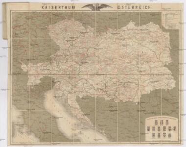
Kaiserthum Oesterreich
1 : 1800000 Rakousko-Uhersko Bomsdorff, Th. von Karl Prochaska
Österreich-Ungarn
1 : 6000000 Österreich-Ungarn
Austrian Empire.
1 : 3380000 Sharpe, J.
Ethnographical map of Austria-Hungary. 1918
1 : 4000000 First World War ethnographical map of Austria-Hungary. 1918. War Office
Prochaska's Eisenbahnkarte von Oesterreich-Ungarn für 1894
1 : 1500000 Evropa jihovýchodní Karl Prochaska
Prochaska's Eisenbahnkarte von Oesterreich-Ungarn für 1892
1 : 1500000 Evropa jihovýchodní Karl Prochaska
Oesterreich-Ungarn Eisenbahn-Karte
1 : 1500000 Budapešť (Maďarsko) Bomsdorff, Theodor von Karl Prochaska
Oesterreich-Ungarn Eisenbahn-Karte
1 : 1500000 Budapešť (Maďarsko) Bomsdorff, Theodor von Karl Prochaska
Oesterreich-Ungarn Eisenbahn-Karte
1 : 1500000 Rakousko-Uhersko Bomsdorff, Theodor von Karl Prochaska
Oesterreich-Ungarn Eisenbahn-Karte
1 : 1500000 Rakousko-Uhersko Bomsdorff, Theodor von Karl Prochaska
Österreich-Ungarn
Rakousko-Uhersko Trausel, W. Steyrer, Fr. C.
Der Oesterreichische Kaiserstaat
1 : 3700000 Evropa jihovýchodní Weiland, Karl Ferdinand im Verlage des Geograph. Instituts
Der Oesterreichische Kaiserstaat
1 : 3700000 Evropa jihovýchodní Weiland, Karl Ferdinand Metzeroth, C. im Verlage des Geograph. Instituts
Uibersichtskarte von Oesterreich in Hinsicht auf Raum- und Bevölkerungs-Verhältnisze der einzelnen Länder dieses Kaiserthumes
Rakousko Schnabel, Jiří Norbert Schönflug, Jakub
Landwehrterritorial- und Landwehr-Ergänzungsbezirkseinteilung
1 : 3000000 Rakousko-Uhersko k.u.k. Militärgeographisches Institut
Militärterritorial und Ergänzungsbezirkseinteilung
1 : 3000000 Rakousko-Uhersko k.u.k. Militärgeographisches Institut
Landwehrterritorial- und Landwehr-Ergänzungsbezirkseinteilung
1 : 3000000 Rakousko-Uhersko k.u.k. Militärgeographisches Institut
Floren-Karte von Österreich-Ungarn
Rakousko-Uhersko Kerner von Marilaun, Anton Wettstein, Richard Ed. Hölzel
Geologische Karte von Österreich-Ungarn
1 : 2016000 Hauer, Franz von Hölder
Eisenbahn-Karte von Oesterreich-Ungarn
Rakousko-Uhersko R. v. Waldheim
Österreich-Ungarn
1 : 4000000 Rakousko-Uhersko Trausel, W. A. Haase
Mittelbach's neueste Hand- und Verkehrskarte von Österreich-Ungarn mit Rumäinen, Bulgarien, Serbien und Montenegro
1 : 1500000 Bulharsko Mittelbach's Verlag
Oesterreich-Ungarn
1 : 4900000 Österreich-Ungarn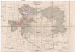
Übersichts-Blatt zur Spezial-Karte der österr[eichisch] ung[arischen] Monarchie
Evropa střední K. u. k. Militärgeographisches Institut
Geologische Karte der Österreich-Ungarischen Monarchie zum Schulgebrauche
1 : 6000000 Evropa jihovýchodní Bisching, A. Hauer, Franz Alfred Hölder
Osterreich – Ungarn

Mocnářství Rakousko - Uherské

Austrian Empire.
1 : 4100000 Tanner, Henry S.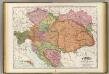
Austria-Hungary.
1 : 2070000 Rand McNally and Company