Maps of Carpathian Mountains

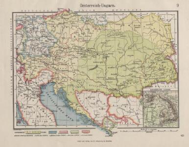
Oesterreich-Ungarn
1 : 4900000 Österreich-Ungarn
Österreich-Ungarn
1 : 6000000 Österreich-Ungarn
Österreichisch-Ungarische Monarchie
Volksschul-Atlas über alle Teile der Erde Lange, Henry Druck und Verlag von Georg Westermann
Kaiserthum Oesterreich
1 : 1800000 Rakousko-Uhersko Bomsdorff, Th. von Karl Prochaska
Wein und Tabak
Österreich-Ungarn Weinbau, Tabakanbau
Österreich-Ungarn, Bevölkerungsdichtigkeit
Österreich-Ungarn Bevölkerungsdichte
Eisenbahn-Karte von Oesterreich-Ungarn
Rakousko-Uhersko R. v. Waldheim
Jährliche Regenmenge
Österreich-Ungarn Gebietsniederschlag
Österreich-Ungarn
Rakousko-Uhersko Trausel, W. Steyrer, Fr. C.
Oesterreichisch-Ungarische Monarchie
1 : 4600000 Österreich-Ungarn
Geologische Karte der Österreich-Ungarischen Monarchie zum Schulgebrauche
1 : 6000000 Evropa jihovýchodní Bisching, A. Hauer, Franz Alfred Hölder
Ackerland
Österreich-Ungarn Bodennutzung
Mineralien
Österreich-Ungarn Mineralischer Rohstoff
Österreich-Ungarn Staaten-Karte
1 : 8000000 Österreich-Ungarn
Tatsächliche Zu- und Abnahme der anwesenden Bevölkerung in den politischen Bezirken der Reichsratsländer im Jahrzehnt 1901 – 1910
Österreich Bevölkerungsentwicklung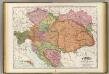
Austria-Hungary.
1 : 2070000 Rand McNally and Company
Austrian Empire.
1 : 3380000 Sharpe, J.
Ethnographical map of Austria-Hungary. 1918
1 : 4000000 First World War ethnographical map of Austria-Hungary. 1918. War Office
Der Oesterreichische Kaiserstaat
1 : 3700000 Evropa jihovýchodní Weiland, Karl Ferdinand im Verlage des Geograph. Instituts
Der Oesterreichische Kaiserstaat
1 : 3700000 Evropa jihovýchodní Weiland, Karl Ferdinand Metzeroth, C. im Verlage des Geograph. Instituts
Uibersichtskarte von Oesterreich in Hinsicht auf Raum- und Bevölkerungs-Verhältnisze der einzelnen Länder dieses Kaiserthumes
Rakousko Schnabel, Jiří Norbert Schönflug, Jakub
Gewebe- und Glasindustrie
Österreich-Ungarn Textilindustrie, Glasindustrie
Österreich-Ungarn, Religionen
Österreich-Ungarn Denomination
Prochaska's Eisenbahnkarte von Oesterreich-Ungarn für 1894
1 : 1500000 Evropa jihovýchodní Karl Prochaska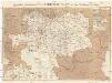
Prochaska's Eisenbahnkarte von Oesterreich-Ungarn für 1892
1 : 1500000 Evropa jihovýchodní Karl Prochaska
Oesterreich-Ungarn Eisenbahn-Karte
1 : 1500000 Budapešť (Maďarsko) Bomsdorff, Theodor von Karl Prochaska
Oesterreich-Ungarn Eisenbahn-Karte
1 : 1500000 Budapešť (Maďarsko) Bomsdorff, Theodor von Karl Prochaska
Oesterreich-Ungarn Eisenbahn-Karte
1 : 1500000 Rakousko-Uhersko Bomsdorff, Theodor von Karl Prochaska
Oesterreich-Ungarn Eisenbahn-Karte
1 : 1500000 Rakousko-Uhersko Bomsdorff, Theodor von Karl Prochaska