Maps of gmina Krotoszyce

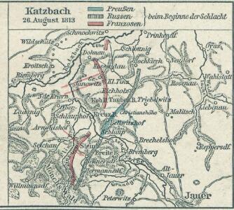
Katzbach 26. August 1813
1 : 300000 Schlesien Katzbach, Katzbach / Schlacht
Die Schlacht an der Katzbach den 26ten August 1813
1 : 25000 Rahden, Wilhelm von; Brose, Karl Heinrich; Prêtre, Jean Gabriel Pretre
Meßtischblatt 2822 : Kroitsch, 1937
1 : 250000 Kroitsch. - Hrsg. 1887, bericht. 1933, einz. Nachtr. 1936, mehrfarb. Ausg. 1937. - 1:25000. - [Berlin]: Reichsamt für Landesaufnahme, 1937. - 1 Kt.
Meßtischblatt 2822 : Kroitsch, 1933
1 : 250000 Kroitsch. - Hrsg. 1887, bericht. 1933. - 1:25000. - [Berlin]: Reichsamt für Landesaufnahme, 1933. - 1 Kt.
Zum Hinterhalt bei Haynau 26. Mai 1813

Meßtischblatt 2886 : Kolbnitz, 1933
1 : 250000 Kolbnitz. - Hrsg. 1888, bericht. 1933. - 1:25000. - [Berlin]: Reichsamt für Landesaufnahme, 1933. - 1 Kt.
Meßtischblatt 2886 : Kolbnitz, 1888
1 : 250000 Kolbnitz. - Aufn. 1886. - 1:25000. - [Berlin]: Reichsamt für Landesaufnahme, 1888. - 1 Kt.
Meßtischblatt 2823 : Wahlstatt, 1936
1 : 250000 Wahlstatt. - Hrsg. 1887, bericht. 1933, einz. Nachtr. 1936. - 1:25000. - [Berlin]: Reichsamt für Landesaufnahme, 1936. - 1 Kt.
Die Schlacht an der Katzbach den 26 ten August 1813
1 : 11000 Kaczawa (Polsko) Rahden, Wilhelm von Brose, Heinrich von Prétre
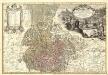
Special-Carte des Fürstenthums Liegnitz in Nieder Schlesien
1 : 230000 Mollova mapová sbírka Schleuen, Johann David
Liegnitz-Hirschberg (Riesengebirge)
1 : 100000 Jelení Hora-oblast (Polsko) Reichsamt für Landesaufnahme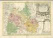

Special-Carte des Fürstenthums Liegnitz in Nieder-Schlesien
Lehnice-oblast (Polsko) Wieland, Johann Wolfgang Schleuen, Johann David Schleuen
Meßtischblatt 2887, neue Nr. 4963 : Jauer, 1938
1 : 250000 Jauer - Hrsg. 1887, bericht. 1933, redakt. Änd. [19]38. - 1:25000. - [Berlin]: Reichsamt für Landesaufnahme, [19]38. - 1 Kt.
118. Liegnitz, uit: Topographische Uebersichtskarte des Deutschen Reiches / herausgegeben v. d. Kartogr. Abt. d. Königl. Preuß. Landesaufnahme
1 : 200000 titelvariant: Topogr. Übersichtskarte des Deutschen Reiches; Annotatie: Titel boven bladen ook: Topogr. Übersichtskarte des Deutschen Reiches; Annotatie geografische gegevens: Op elk blad twee maatstokken: 10 Kilometer = 5,5 cm; 1 geogr. Meile = 3,6 cm; Legenda onder op elk blad Königlich Preußische Landesaufnahme. Kartographische Abtheilung [S.l : Königlich Preußische Landesaufnahme, Kartographische Abtheilung]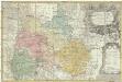
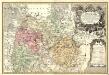
Principatvs Silesiae Lignicensis in suos circulos, tres nempe Lignicenses Goldbergensem, Haynavviensem et Lvbenensem divisi
1 : 100000 Lehnice (Polsko) Wieland, Johann Wolfgang Schubarth, Matthäus Homannianos Heredes
Ducatus Silesiae Ligniciensis
1 : 170000 Mollova mapová sbírka Aveele, Johannes van den Schenk, Peter I
Dvcatvs Silesiae Ligniciensis
1 : 160000 Mollova mapová sbírka Scultetus, Johannes Blaeu, Joan I.
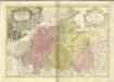
Principatvs Silesiae in suos circulos, tres nempe Lignicenses Goldbergensem, Haynavviensem et Lvbenensem divisii
1 : 100000 Mollova mapová sbírka Wieland, Johann Wolfgang Homann, Johann Baptista - dědici


Karte des Riesengebirges
1 : 200000 Krkonoše (Česko a Polsko : pohoří : oblast) Reymann, Gottlob Daniel C. Flemming
DVCATVS | SILESIÆ | LIGNICIENSIS
Auctore | Iona Sculteto Sprotta Silesio Amstelædami J. Blaeu excud.
DVCATVS | SILESIÆ | SCHWIDNICENSIS
Authore Friduico Kuhnovio | Bolco-lucano Silesio. [Amsterdam : Joan Blaeu]
Ducatus Silesiae Ligniciensis. [Karte], in: Novus atlas absolutissimus, Bd. 2, S. 267.
1 Karte aus Atlas Janssonius Offizin
Generální mapa ČSR

Ducatuum Silesiae Svidnicensis et Iavraviensis Delineatio :
1 : 208000 Mollova mapová sbírka Köhler, Gottfried Posch, C.