Maps of powiat legnicki

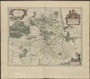
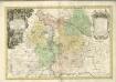
DVCATVS | SILESIÆ | LIGNICIENSIS
Auctore | Iona Sculteto Sprotta Silesio Amstelædami J. Blaeu excud.
Ducatus Silesiae Ligniciensis. [Karte], in: Novus atlas absolutissimus, Bd. 2, S. 267.
1 Karte aus Atlas Janssonius Offizin

Ducatus Silesiae Ligniciensis
1 : 170000 Mollova mapová sbírka Aveele, Johannes van den Schenk, Peter I
Dvcatvs Silesiae Ligniciensis
1 : 160000 Mollova mapová sbírka Scultetus, Johannes Blaeu, Joan I.
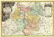
Principatvs Silesiae Lignicensis in suos circulos, tres nempe Lignicenses Goldbergensem, Haynavviensem et Lvbenensem divisi
1 : 100000 Lehnice (Polsko) Wieland, Johann Wolfgang Schubarth, Matthäus Homannianos Heredes
Principatvs Silesiae in suos circulos, tres nempe Lignicenses Goldbergensem, Haynavviensem et Lvbenensem divisii
1 : 100000 Mollova mapová sbírka Wieland, Johann Wolfgang Homann, Johann Baptista - dědici

Special-Carte des Fürstenthums Liegnitz in Nieder-Schlesien
Lehnice-oblast (Polsko) Wieland, Johann Wolfgang Schleuen, Johann David Schleuen
118. Liegnitz, uit: Topographische Uebersichtskarte des Deutschen Reiches / herausgegeben v. d. Kartogr. Abt. d. Königl. Preuß. Landesaufnahme
1 : 200000 titelvariant: Topogr. Übersichtskarte des Deutschen Reiches; Annotatie: Titel boven bladen ook: Topogr. Übersichtskarte des Deutschen Reiches; Annotatie geografische gegevens: Op elk blad twee maatstokken: 10 Kilometer = 5,5 cm; 1 geogr. Meile = 3,6 cm; Legenda onder op elk blad Königlich Preußische Landesaufnahme. Kartographische Abtheilung [S.l : Königlich Preußische Landesaufnahme, Kartographische Abtheilung]
Special-Carte des Fürstenthums Liegnitz in Nieder Schlesien
1 : 230000 Mollova mapová sbírka Schleuen, Johann David

Das Fürstenthum Wohlau in Nieder-Schlesien
1 : 980000 Dolní Slezsko Schleuen, Johann David Schleuen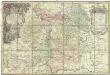
Principatvs Silesiae Wolani in suos circulos, Wohlav, Wintzig, Herrnstadt, Rützen, Steinav und Ravden divisi
1 : 100000 Slezsko Wieland, Johann Wolfgang Schubarth, Matthäus Homannianos Heredes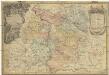
Principatvs Silesiae Wolani in suos circulos, Wohlav, Wintzig, Herrnstadt, Rützen, Steinav und Ravden divisi
1 : 100000 Slezsko Wieland, Johann Wolfgang Schubarth, Matthäus ab Hered. Homan[n]ianis
Die Schlacht an der Katzbach den 26 ten August 1813
1 : 11000 Kaczawa (Polsko) Rahden, Wilhelm von Brose, Heinrich von Prétre
Das Fürstenthum Wohlau in Nieder-Schlesien
1 : 240000 Mollova mapová sbírka Schleuen, Johann David Schleuen, Johann David
Zum Hinterhalt bei Haynau 26. Mai 1813
Principatvs Silesiae Wolani in suos Circulos, Wohlav, Wintzig, Herrnstadt, Rützen, Steinav und Ravden divisi
1 : 930000 Mollova mapová sbírka Wieland, Johann Wolfgang Homann, Johann Baptista - dědici
Katzbach 26. August 1813
1 : 300000 Schlesien Katzbach, Katzbach / Schlacht
Die Schlacht an der Katzbach den 26ten August 1813
1 : 25000 Rahden, Wilhelm von; Brose, Karl Heinrich; Prêtre, Jean Gabriel Pretre
Meßtischblatt 2889 : Kostenblut, 1936
1 : 250000 Kostenblut. - Hrsg. 1889, bericht. 1932, einz. Nachtr. 1936. - 1:25000. - [Berlin]: Reichsamt für Landesaufnahme, 1936. - 1 Kt.
Meßtischblatt 2889 : Kostenblut, 1889
1 : 250000 Kostenblut. - Aufn. 1887. - 1:25000. - [Berlin]: Reichsamt für Landesaufnahme, 1889. - 1 Kt.
Meßtischblatt Kuhnern
1 : 250000 Kuhnern. - Hrsg. 1889, bericht. 1932, einz. Nachtr. 1936. - 1:25000. - [Berlin]: Reichsamt für Landesaufnahme, 1936. - 1 Kt.
Meßtischblatt Kuhnern
1 : 250000 Kuhnern. - Hrsg. 1889, bericht. 1932, einz. Nachtr. 1936. - 1:25000. - [Berlin]: Reichsamt für Landesaufnahme, 1936. - 1 Kt.
Meßtischblatt 2888 : Kuhnern, 1934
1 : 250000 Kuhnern. - Hrsg. 1889, bericht. 1932, gedr. [19]34. - 1:25000. - [Berlin]: Reichsamt für Landesaufnahme, 1934. - 1 Kt.
Meßtischblatt 2888 : Kuhnern, 1889
1 : 250000 Kuhnern. - Aufn. 1887. - 1:25000. - [Berlin]: Reichsamt für Landesaufnahme, 1889. - 1 Kt.
Meßtischblatt 2886 : Kolbnitz, 1933
1 : 250000 Kolbnitz. - Hrsg. 1888, bericht. 1933. - 1:25000. - [Berlin]: Reichsamt für Landesaufnahme, 1933. - 1 Kt.