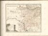
Maps of Nowy Dwór Mazowiecki
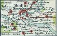
[Modlin]
1 : 350000 Modlin Stary Belagerung, Weltkrieg <1914-1918>
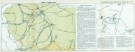
Die Eroberung von Neu-Georgiewsk. (19. August 1915.)
Nowy Dwór Mazowiecki- Modlin Festung, Eroberung
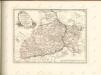
Übersicht des österrechisch-russischen Kriegsschauplatzes
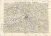
Mapa topograficzna okolic Warszawy
1 : 100000 Varšava-oblast (Polsko) Wojskowy instytut geograficzny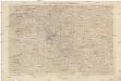
Karte der Umgegend von Warschau
1 : 100000 Varšava-oblast (Polsko) Kartogr. Abteilung des Stellvertretenden Generalstabes des Armee
Warschau 52, uit: Special-Karte von Mittel-Europa / nach amtlichen Quellen bearbeitet von W. Liebenow
1 : 300000 titelvariant: W. Liebenow's Mittel-Europa; Annotatie: Titel boven de bladen: W. Liebenow's Mittel-Europa Johannes Wilhelm Liebenow 1822-1897 Frankfurt a. M. : Ludwig Ravenstein
Warszawa

Mapa fizyczna okolic Warszawy
1 : 400000 Varšava-oblast (Polsko) Inst. Wojsk. Geograficznego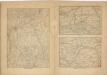
Kriegs Atlas 36 Karten von den Schauplätzen des Weltkrieges 1914/1915

Warszawa, Brest-Litowsk, Radom, Lublin, Kielze, Tomaszów

Topographische Karte der Gegend um Warschau
Varšava-oblast (Polsko) Artaria
Warschau, Lublin, Modlin (Nowogeorgiewsk)
1 : 750000 Lublin (Polsko : oblast) Karl, E. K. u. k. Militärgeographisches Institut
Warschau, Lublin, Nowo-Georgiewsk
1 : 750000 Lublin (Polsko : oblast) K. k. militär-geographisches Institut
Schema Teatra kampanīi 1806-7 gg.
Polen Napoleonische Kriege
General-Carte von Westgallizien
1 : 291000 Polsko jihovýchodní Benedicti, Lucas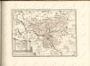
Nr. 13. Einfälle in Russisch-Polen
Polen Weltkrieg <1914-1918>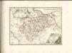

Nr. 12. Die ersten Schlachten in Ostpreußen
Ostpreußen Weltkrieg <1914-1918>

Zweite Offensive in Polen
1 : 4000000 Polen Feldzug, Weltkrieg <1914-1918>
[Polen]
1 : 800000 Polsko S. Hirzel
West-Galizien
1 : 850000 Halič (Polsko a Ukrajina) Metzburg, Georg Ignaz von Junker, Ch. T. Mollo und Comp.
Ducatus Silesiae Tabula
1 : 2800000 1 Karte : Kupferdruck ; 13 x 17 cm Weigel, Johann Christoph [Johann Christoph Weigel]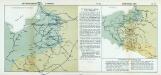
Nr. 18a. Die Winterschlacht in Masuren
Masuren Weltkrieg <1914-1918>, Ostfront
Silesiae Typus...

Prussiae Descriptio [Karte], in: Theatrum orbis terrarum, S. 59.
1 Karte aus Atlas Ortelius, Abraham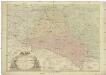
![[Modlin]](https://images-2.georeferencer.com/images/iiif/983123577442/full/,300/0/native.jpg)

