Maps of Podlachian
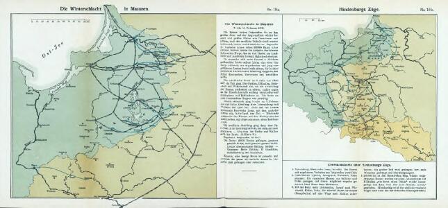
Nr. 18a. Die Winterschlacht in Masuren
Masuren Weltkrieg <1914-1918>, Ostfront
(La Prusse)
1 : 4000000 Bruyset, Jean-Marie; Schneider, J. H.
Karte der Eisenbahnen Deutschlands
1 : 700000 Nordost-Blatt Stich, Druck u. Verlag des lithographischen Instituts von Aug. Wehrt

Burgen-Karte von Preussen zur Zeit Deutschen Ordens
1 : 750000 Prusko Fischer, von Herwig, C. G.
Nr. 12. Die ersten Schlachten in Ostpreußen
Ostpreußen Weltkrieg <1914-1918>

Prussia.
1 : 1900000 Bowen, Frances
La Prusse.
1 : 720000 Robert de Vaugondy, Gilles, 1688-1766
Tabula PRUSSIAE EXIMIA CURA CONSCRIPTA
1 : 710000 Kaliningrad (Rusko) Hennenberger, Kaspar Goos, Abraham per Nicolaum Iohannidem Piscatorem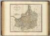
Prussia.
1 : 840000 Cary, John, ca. 1754-1835
Karte von dem Koenigreiche Preussen
1 : 745000 Prusko Reilly, Franz Johann Josef von Franz Ioh. Ios. von Reilly
Karte von dem Koenigreiche Preussen
1 : 745000 Prusko Reilly, Franz Johann Josef von Endersch, Johann Friedrich Franz Ioh. Ios. von Reilly
REGNI PRUSSIAE accurata delineatio
1 : 2500000 Prusko
Prussia Accurate Descripta [Karte], in: Le théâtre du monde, ou, Nouvel atlas contenant les chartes et descriptions de tous les païs de la terre, Bd. 1, S. 97.
1 Karte aus Atlas Blaeu, Willem Janszoon und Blaeu, Joan Blaeu, Willem Janszoon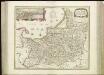
[72][72] Tabula Prussiae , uit: Atlas sive Descriptio terrarum orbis
Annotatie: Gedigitaliseerde versie. Amsterdam. Heiloo : Picturae (vervaardiger), 2015. tiff-bestand. Gedigitaliseerd: 07-01-2015; Origineel: Universiteitsbibliotheek Vrije Universiteit (XL.05127.-) ; Netherlands; Titelpagina ontbreekt Wit, Frederik de Amsterdam : Frederick de Wit
Borussiae regnum cum adjacentibus regionibus mappa geographica delineat
1 : 1760000 Neuchâtel (Švýcarsko) Seutter, Matthäus Silbereisen, Andreas T.C. Lotter
Prussia [Karte], in: Atlas, sive, Cosmographicae meditationes de fabrica mundi et fabricati figura, S. 147.
1 Karte aus Atlas Mercator, Gerhard
Prussia Accurate Descripta [Karte], in: Gerardi Mercatoris et I. Hondii Newer Atlas, oder, Grosses Weltbuch, Bd. 1, S. 118.
1 Karte aus Atlas Mercator, Gerhard und Hondius, Jodocus Jansson, Jan
Magnae Prussiae ducatus tabula
1 : 711000 Prusko Visscher, Nicolaus per Nicolaum Visscher
Prussiae Vera Descriptio. [Karte], in: Theatrum orbis terrarum, S. 372.
1 Karte aus Atlas Ortelius, Abraham Vrients, Jan Baptista
Prussia [Karte], in: Gerardi Mercatoris Atlas, sive, Cosmographicae meditationes de fabrica mundi et fabricati figura, S. 152.
1 Karte aus Atlas Mercator, Gerhard Montanus, Petrus
Prussia Accurate Descripta [Karte], in: Theatrum orbis terrarum, sive, Atlas novus, Bd. 1, S. 97.
1 Karte aus Atlas Blaeu, Joan Blaeu, Willem Janszoon
Ost- u. Westpreussen.
1 : 1500000 Andree, Richard
Prussiae Descriptio [Karte], in: Theatrum orbis terrarum, S. 59.
1 Karte aus Atlas Ortelius, Abraham
Ost- und Westpreussen
1 : 2250000 Ostpreußen Skizzenbuch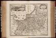
Tabula Prussiae eximia cura conscripta / per Casparum Henneberch Erlichensem et denuo edita per Nicolaum Iohannidem Piscatorem ; A. Goos sculpsit
1 : 720000 Annotatie: Origineel is Blad 93 in atlas factice; Annotatie geografische gegevens: Bevat 3 schaalstokken: Milliaria parva, Milliaria mediocria, Milliaria magna; Inzet: stadsgezicht van Konigsberg Caspar Henneberger 1529-1600; Abraham Goos ca. 1589/90-1643 [Amstelodami] : [Nicolaes Jansz. Visscher]
Prussia Accurate Descripta [Karte], in: Novus atlas absolutissimus, Bd. 1, S. 107.
1 Karte aus Atlas Janssonius Offizin