Maps of Balkan Pen.
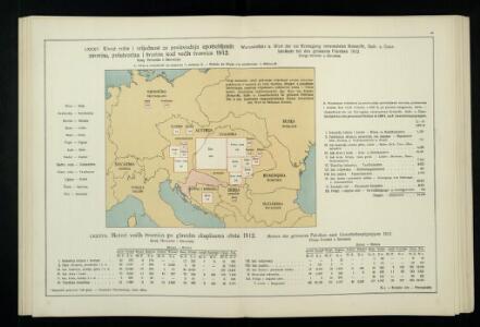
Uvoz robe i vrijednost za proiyvodnju upotrebljenih sirovina, polutvorina i tvorina kod većih tvornica 1912. Kralj. Hrvatska i Slavonija
Kroatien Slawonien Import Statistik Industrie
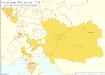
8. Mittel und Ost-Europa oder Germanien und die illyrischen Provinzen des Römischen Reichs
Römisches Reich, Germanische Provinzen
Germania, Dacia.
1 : 13000000 Fenner, Rest.
Skelet zur Übersichtskarte von Mittel-Europa im Masse 1:750 000 und zur Hypsometrischen Karte der österr[isch-] ungar[ischen] Monarchie
1 : 750000 Rakousko-Uhersko R. Lechner
Übersichtskarte der Staaten von Mitteleuropa

Geogr.-physik.-statist. Karte von Deutschland mit Einschluss von ganz Oesterreich, Belgien, den Niederlanden, der Schweiz, Italien und einem Theile von Frankreich, England, Russland und der Türkei
1 : 4110000 Evropa střední a východní Haurand Theobald Grieben
Central Europe.
1 : 7303000 Fisher, Richard Swainson
Der Oesterreichische Kaiser-Staat
Hand-Atlas über alle Theile der Erde nach dem neuesten Zustande und über das Weltgebäude Stieler, Adolf bei Justus Perthes
Österreichisch-Ungarische Monarchie
Handatlas über alle Theile der Erde und über das Weltgebäude Stieler, Adolf Justus Perthes
Mitteleuropa
1 : 8000000 Evropa střední Kocen, Blaž Eduard Hölzel
Sbírka map a diagramů použitých na mírových konferencích v Paříži v letech 1919 - 1920

Sbírka map a diagramů použitých na mírových konferencích v Paříži v letech 1919 - 1920

Geogr.-physik.-statist. Karte von Deutschland mit Einschluss von ganz Oesterreich, Belgien, den Niederlanden, der Schweiz, Italien und einem Theile von Frankreich, England, Russland und der Türkei
1 : 4000000 Evropa střední Haurand, Theodor C. W.
Neuer Atlas der ganzen Erde nach den neuesten Bestimmungen für Zeitungsleser

Mitteleuropa: Konfessionsgebiete
1 : 9000000 Mitteleuropa Denomination
Mittel-Europa Österreich-Ungarn. Naturkarte
1 : 5000000 Mitteleuropa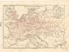
Eisenbahnkarte von Mitteleuropa
Karte der floss- und schiffbaren Flüsse von Mittel-Europa
1 : 3000000 Evropa střední Jelussig, Othmar Kiepert, Heinrich
Oesterreich in den Jahren 1564-1795
Evropa střední Gindely, Antonín F. Tempsky
Oesterreich im Jahre 1564, 1720, 1795.
Rakousko Benecke Bormann, E. F. Tempsky
Post roads Germany, Hungary.
1 : 2500000 Robert Laurie & James Whittle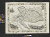
Austria
From Austria
Carte élémentaire et statistique de l'Allemagne
1 : 2700000 Brion de La Tour, Louis Brion & Maire
La barriere anti-germanique
Evropa střední a východní Conseil National Tchécoslovaque
Eisenbahn-Übersichtskarte von Mittel-Europa
Evropa R. v. Waldheim
Habsburger Monarchie 1797 nach dem Frieden von Campo Formio
Österreich Friede von Campo Formio Kunz, Andreas ; Moeschl, Joachim Robert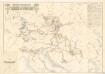
Übersichtskarte zur Geschichte des k.u.k. Infanterieregiments Kaiser No. 1

Österreich-Ungarn, Staatenkarte
1 : 4500000 Österreich-Ungarn
Die Donauländer
1 : 5000000 Österreich-Ungarn, Balkanhalbinsel