Maps of Balkan Pen.
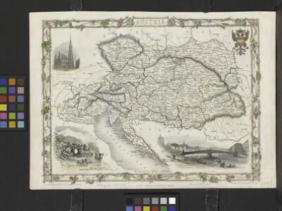
Austria
From Austria
Völkerkarte von Mittel-und Südosteuropa
1 : 15000000 Mitteleuropa, Südosteuropa, ethnische Gruppe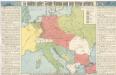
So wollten unsere Feinde Europa nach dem Kriege gestalten

Die grossen Friedensschlüsse II (1735 - 1812). Frankreichs, Rußlands und Englands Vorschreiten 1801-1812
1 : 20000000 Mitteleuropa, Osteuropa, Napoleonische Kriege
Conspectus Generalis omnium earum partium quae unquam ad Imperium Francicum vel Franco-Romanum demum Romano-Germanicum diversis temporum periodis pertinuerunt.
1 : 11000000 Mollova mapová sbírka Homann, Johann Baptist Homann, Johann Baptista - dědici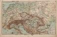
Mittel-Europa Österreich-Ungarn. Naturkarte
1 : 5000000 Mitteleuropa
32. Mitteleuropa nach dem Reichsdeputationshauptschluss im Jahre 1803
Mitteleuropa Reichsdeputationshauptschluss
Österreichisch-Ungarische Monarchie
Handatlas über alle Theile der Erde und über das Weltgebäude Stieler, Adolf Justus Perthes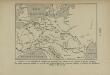
La Germanie à l’époque des invasions des Cimbres et des Teutons à travers l’Europe
Mitteleuropa Germanien Kimbern Teutonen Augustus
Veränderungen der Karte von Europa seit 1815
1 : 3800000 Evropa Wenzel, Joh. K. J.G. Calve'sche k. k. Hof- und Universitäts-Buchhandlung
Le Cours Du Danube Depuis sa Source Iusqu'a ses Embouchures [Karte] Le Bosphore De Thrace [...] [Nebenkarte], in: Atlas nouveau, contenant toutes les parties du monde [...], Bd. 1, S. 249.
1 Karte aus Atlas Sanson, Nicolas Jaillot, Alexis Hubert und Mortier, Pieter
[Europa's Haupt-Gebirgs-Systeme]
Erster Band, enthaltend in vier Abtheilungen die Erscheinungen der anorganischen Natur: 1. Meteorologie und Klimatographie. 2. Hydrologie und Hydrographie. 3. Geologie. 4. Tellurischer Magnetismus Humboldt, Alexander von Verlag von Justus Perthes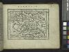
Germania.
from Abraham Ortelius his epitome of the theater of the worlde / nowe latlye ... renewed and augmented ... by Micheal Coignet, mathematitian of Antwarpe.
Sbírka map a diagramů použitých na mírových konferencích v Paříži v letech 1919 - 1920

Mitteleuropa
1 : 3000000 Evropa střední Kartogr. Anstalt G. Freytag & Berndt
Sbírka map a diagramů použitých na mírových konferencích v Paříži v letech 1919 - 1920

Geogr.-physik.-statist. Karte von Deutschland mit Einschluss von ganz Oesterreich, Belgien, den Niederlanden, der Schweiz, Italien und einem Theile von Frankreich, England, Russland und der Türkei
1 : 4110000 Evropa střední a východní Haurand Theobald Grieben
8. Mittel und Ost-Europa oder Germanien und die illyrischen Provinzen des Römischen Reichs
Römisches Reich, Germanische Provinzen
Mitteleuropa
1 : 8000000 Evropa střední Kocen, Blaž Eduard Hölzel
Skelet zur Übersichtskarte von Mittel-Europa im Masse 1:750 000 und zur Hypsometrischen Karte der österr[isch-] ungar[ischen] Monarchie
1 : 750000 Rakousko-Uhersko R. Lechner
Der Oesterreichische Kaiser-Staat
Hand-Atlas über alle Theile der Erde nach dem neuesten Zustande und über das Weltgebäude Stieler, Adolf bei Justus Perthes
Ethnographical map of central & south eastern Europe. 1916.
1 : 4000000 First World War ethnographical map of central & south eastern Europe. 1916. War Office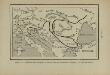
Marche des Ostrogoths à travers l’Europe méridionale
Mitteleuropa Ostgoten Völkerwanderungszeit Völkerwanderung
Habsburger Monarchie 1797 nach dem Frieden von Campo Formio
Österreich Friede von Campo Formio Kunz, Andreas ; Moeschl, Joachim Robert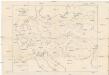
Karte der floss- und schiffbaren Flüsse von Mittel-Europa
1 : 3000000 Evropa střední Jelussig, Othmar Kiepert, Heinrich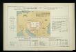
Uvoz robe i vrijednost za proiyvodnju upotrebljenih sirovina, polutvorina i tvorina kod većih tvornica 1912. Kralj. Hrvatska i Slavonija
Kroatien Slawonien Import Statistik Industrie
Post roads Germany, Hungary.
1 : 2500000 Robert Laurie & James Whittle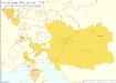
Habsburger Monarchie 1772 nach der ersten polnischen Teilung
Österreich, Teilung Polens <1772> Kunz, Andreas ; Moeschl, Joachim Robert
Geogr.-physik.-statist. Karte von Deutschland mit Einschluss von ganz Oesterreich, Belgien, den Niederlanden, der Schweiz, Italien und einem Theile von Frankreich, England, Russland und der Türkei
1 : 4000000 Evropa střední Haurand, Theodor C. W.