Maps of Chavusy District

Operacīja Petra Velikago protiv Levengaupta.
Europa
Plan‘‘sraženija pri Krasnom‘‘, 5 nojabrja
Russland Krasnoj Russlandfeldzug <1812>
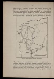
Boj pri d. Lěsnoj 28 sentjabrja 1708 g.
Weißrussland Lesnaya Nordischer Krieg <1700-1721>
Dviženīe 1j i 2j armīi k Smolensku.
Russland Smolensk Russlandfeldzug <1812>
Plan sraženīja pri Smolensk, 5 avgusta.
Russland Smolensk Russlandfeldzug <1812>
Strategische Übersichts-Karte des polnisch-litaurischen Armee-Bewegungraumes

Li palatinati di Minsk, Mscislaw, Polok, e Witebsk nella Littuania / tratta dall'atlante polacco del
1 : 1400000 1 Karte : Kupferdruck ; 40 x 30 cm Zuliani, Giuliano presso Antonio Zatta

Charte von Russisch Litauen
1 : 1320000 Bělorusko auf Kosten der Homännischen Erben
Charte von Russisch Litauen
1 : 1320000 Bělorusko auf Kosten der Homännischen Erben
Charte von Russisch Litauen
1 : 1320000 Bělorusko auf Kosten der Homännischen Erben
Delineatio memorabilis conflictus et victoriae Lithuanorum Duce Radivilio de Cricevio
Bělorusko
Castra defensiva Ducis Radiuly Reciciae, obiecta aduentui Eliae Bohaczenlio
Bělorusko
Übersichtskarte von Mittel - Europa
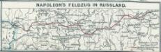
Napoleon's Feldzug in Russland
1 : 7500000 Russland / Europäischer Teil Russlandfeldzug <1812>
Kijew, Žitomir, Owrucz, Czernobyl, Mozyr, Łojew
1 : 750000 Kyjev (Ukrajina : oblast) Korb, L. K. u. k. Militärgeographisches Institut
Bobrujsk, Czerikow, Str. Szkłow
1 : 750000 Bobrujsk (Bělorusko) Dornhofer, J. K. u. k. Militärgeographisches Institut
Bobrujsk, Czerikow, Str. Szkłow
1 : 750000 Bobrujsk (Bělorusko) K. k. militär-geographisches Institut
Kijew, Žitomir, Owrucz, Czernobyl, Mozyr, Łoiew
1 : 750000 Kyjev (Ukrajina : oblast) K. k. militär-geographisches Institut

Übersichtskarte von Mittel - Europa

Karta Černigovskoj gubernii
1 : 840000 Černigov-oblast (Ukrajina) Kartogr. zav. A. Il'jina
[Recto], uit: Archangel Port : revised plan of saw mills and loading places
1 : 90000 Annotatie geografische gegevens: Met legenda, 1-45 Archangel : A.J. Anderson & Son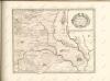

Połock, Witebsk, Smolensk
1 : 750000 Polack (Bělorusko) K. u. k. Militärgeographisches Institut
Plan dījstvīj pred Lubinskim sraženīem
Russland Smolensk Russlandfeldzug <1812>
IV, uit: General-Karte von Mittel-Europa in 12 Blättern, im Masse 1:1.200.000 / entworfen, bearb. und hrsg. von Josef Schlacher
1 : 1200000 Annotatie: Blad 6 ontbreekt; Annotatie geografische gegevens: 21 maatstokken op blad 9; Legenda op blad 9 Wien : K.K. Militär Geografisches Institut
Moskowisch-Litthauisches Grenzgebiet
1 : 6000000 Polen-Litauen, Moskauer Reich, Grenze
Magnus ducatus Lithuania in suos Palatinatus et Castellanias divisa non solum accuratisime delineata, sed etiam plurimis in alliis Mappis omissis locis
1 : 1350000 Georg Friderich Lotter, sculps. Aug. Vind. : Tob. Conr. Lotter