Maps of Landkreis Neustadt an der Waldnaab

154. Bayreuth, uit: Topographische Uebersichtskarte des Deutschen Reiches / herausgegeben v. d. Kartogr. Abt. d. Königl. Preuß. Landesaufnahme
1 : 200000 titelvariant: Topogr. Übersichtskarte des Deutschen Reiches; Annotatie: Titel boven bladen ook: Topogr. Übersichtskarte des Deutschen Reiches; Annotatie geografische gegevens: Op elk blad twee maatstokken: 10 Kilometer = 5,5 cm; 1 geogr. Meile = 3,6 cm; Legenda onder op elk blad Königlich Preußische Landesaufnahme. Kartographische Abtheilung [S.l : Königlich Preußische Landesaufnahme, Kartographische Abtheilung]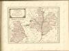

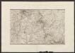
Bavaria 1:50,000, Tirschenreuth (West)
Bavaria 1:50 000, Series GSGS 4492. Great Britain. Ordnance Survey. [London] : War Office
Meßtischblatt 166 : Kaltenbrunn, 1928
1 : 250000 Kaltenbrunn. - Aufn. 1905/1925. - 1:25000. - München, 1928. - 1 Kt.
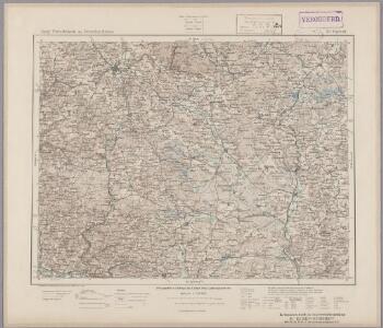
Meßtischblatt 6237 : Grafenwöhr, 1938
1 : 250000 Grafenwöhr. - Aufn. 1905/23, Ausg. 1927, Erkund. 1937, bericht. 1938. - 1:25000. - München, 1938. - 1 Kt.
Meßtischblatt [6236] : Eschenbach i.d. OPf., 1933
1 : 250000 Eschenbach i.d. OPf. - Aufn. 1930, Ausg. 1932, Nachtr. 1933. - 1:25000. - München: Topograph. Zweigstelle d. Bayer. Landesvermessungsamts, 1933. - 1 Kt.
Meßtischblatt 6235 : Pegnitz, 1944
1 : 250000 Pegnitz. - Aufn. 1938, Ausg. 1944. - 1:25000. - München, 1944. - 1 Kt.
Meßtischblatt 6234 : Pottenstein, 1941
1 : 250000 Pottenstein. - Aufn. 1938, Ausg. 1941. - 1:25000. - München: Hauptvermessungsabt. XIII, 1941. - 1 Kt.
Meßtischblatt 6139 : Falkenberg, 1938
1 : 250000 Falkenberg. - Aufn. 1924/25, Ausg. 1928, Erkund. 1937, bericht. 1938. - 1:25000. - München: Hauptvermessungsabteilung XIII, 1938. - 1 Kt.
Meßtischblatt 125 : Erbendorf, 1933
1 : 250000 Erbendorf. - Aufn. 1922, 23, Ausg. 1928, Nachtr. 1933. - 1:25000. - Topograph. Zweigstelle d. Bayer. Landesvermess, 1933. - 1 Kt.
Meßtischblatt 125 : Erbendorf, 1928
1 : 250000 Erbendorf. - Aufn. 1922, 23, Ausg. 1928. - 1:25000. - [München]: Bayer. Topographisches Bureau, 1928. - 1 Kt.
Meßtischblatt 124 : Kemnath, 1933
1 : 250000 Kemnath. - Aufn. 1922,25, Ausg. 1929, Nachtr. 1933. - 1:25000. - [München]: Topograph. Zweigstelle d. Bayer. Land, 1933. - 1 Kt.
Bestandeskarte der Reviere Brand-Hochwald für die Excursion des deutschen Forstvereins im Juli 1907
1 : 11520 Böhm, Fritz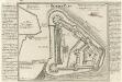
Der Rothe-Berg.
Mollova mapová sbírka Bodenehr, Gabriel Bodenehr, Gabriel
Die Herzschafft Rothenberg unweit Nürnberg gegen der Oberen Pfaltz gelegen.
1 : 80000 Mollova mapová sbírka Bodenehr, Gabriel Bodenehr, Gabriel
Tabulae Marchionatus Brandenburgico-Culmbacensis sive Baruthini Pars Superior cum adjacentibus Regionibus exhibita
1 : 180000 Mollova mapová sbírka Riediger, Johann Adam Seutter, Matthäus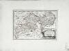
Des Herzogthums Oberpfalz nördliche Pfleggerichte mit der gefürsteten Grafschaft Sternstein
1 Karte : Kupferdruck ; 18 x 27 cm Reilly F. J. J. von Reilly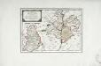
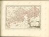
Das Fürstenthum Sulzbach und die Landgrafschaft Leuchtenberg
1 Karte : Kupferdruck ; 19 x 28 cm Reilly F. J. J. von Reilly
Sacri Romani imperii circuli et electoratus Bavariae tabula, 1
4 Blätter : s.n.
Tabulae principatus Brandenburgico-Culmbacensis sive Baruthini
1 : 225600 Bavorsko severní (Německo) Riediger, Johann Adam Lotter, Tobias Conrad I.A. Riediger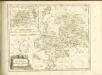

Generální mapa ČSR

Mappa Geographica Territorii Sacri Romani Imperii liberae Civitatis Norimbergensis
1 : 150000 Mollova mapová sbírka Cnopf, Matthäus Ferdinand Hauer, Daniel Adam Homann, Johann Baptista - dědici
Theil von Baierno
Bavorsko (Německo) im Verlage des Geogr. Instituts

Bezirck Der Nürnbergischen Pfleg Aembter Herrspruck Reicheneck Engelthal und Hohenstein im Alten Nordgau gelegen
1 : 45000 Mollova mapová sbírka Scheurer, Christoph
Bavaria 1:50,000, Tirschenreuth (East)
Bavaria 1:50 000, Series GSGS 4492. Great Britain. Ordnance Survey. [London] : War Office
Sacri imperii Romani circuli et electoratus Bavariæ, 1
1 Karte : mehrfarbig ; R. et J. Ottens