Maps of Waldershof

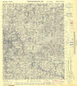
Bavaria 1:50,000, Tirschenreuth (West)
Bavaria 1:50 000, Series GSGS 4492. Great Britain. Ordnance Survey. [London] : War Office
Meßtischblatt 125 : Erbendorf, 1933
1 : 250000 Erbendorf. - Aufn. 1922, 23, Ausg. 1928, Nachtr. 1933. - 1:25000. - Topograph. Zweigstelle d. Bayer. Landesvermess, 1933. - 1 Kt.
Meßtischblatt 125 : Erbendorf, 1928
1 : 250000 Erbendorf. - Aufn. 1922, 23, Ausg. 1928. - 1:25000. - [München]: Bayer. Topographisches Bureau, 1928. - 1 Kt.
Meßtischblatt 124 : Kemnath, 1933
1 : 250000 Kemnath. - Aufn. 1922,25, Ausg. 1929, Nachtr. 1933. - 1:25000. - [München]: Topograph. Zweigstelle d. Bayer. Land, 1933. - 1 Kt.
Bestandeskarte der Reviere Brand-Hochwald für die Excursion des deutschen Forstvereins im Juli 1907
1 : 11520 Böhm, Fritz
Meßtischblatt 5938 : Marktredwitz, 1938
1 : 250000 Marktredwitz. - Aufn. 1919, Ausg. 1924, Erkund. 1937, bericht. 1938. - 1:25000. - München, 1938. - 1 Kt.
Meßtischblatt 5937 : Fichtelberg, 1940
1 : 250000 Fichtelberg. - Aufn. 1936, Ausg. 1937, bereinigt 1940. - 1:25000. - München, 1940. - 1 Kt.
Franzensbad und Seine Umgebung

Generální mapa ČSR

Eger
Cheb-oblast (Česko) Woerl Assner, L.
154. Bayreuth, uit: Topographische Uebersichtskarte des Deutschen Reiches / herausgegeben v. d. Kartogr. Abt. d. Königl. Preuß. Landesaufnahme
1 : 200000 titelvariant: Topogr. Übersichtskarte des Deutschen Reiches; Annotatie: Titel boven bladen ook: Topogr. Übersichtskarte des Deutschen Reiches; Annotatie geografische gegevens: Op elk blad twee maatstokken: 10 Kilometer = 5,5 cm; 1 geogr. Meile = 3,6 cm; Legenda onder op elk blad Königlich Preußische Landesaufnahme. Kartographische Abtheilung [S.l : Königlich Preußische Landesaufnahme, Kartographische Abtheilung]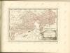

Asch.
from Spezialkarte der osterreichisch-ungarischen Monarchie.
Repraesentatio Geograpica Circuli Egerani nec non Elnbogensis
1 : 80000 Cheb-oblast (Česko) Müller, Johann Christoph Homannios Heredes
Mappa Chorographica Districtus Egrani
1 : 80000 Cheb-oblast (Česko) Müller, Johann Christoph Haberstumpff, Nicolas Christoph Weigel
Districtus Egranus
1 : 80000 Cheb-oblast (Česko) Müller, Johann Christoph Weigel, Christoph Christoph Weigel
Aš
1 : 75000 Aš (Česko : oblast) Vojenský zeměpisný ústav
Aš
1 : 75000 Aš-oblast (Česko) Vojenský zeměpisný ústav
III. vojenské mapování 3948
1 : 75000
Asch
1 : 75000 Aš (Česko : oblast) Ansion K. u. k. Militärgeographisches Institut
Asch
1 : 75000 Aš (Česko : oblast) K. u. k. Militärgeographisches Institut
III. vojenské mapování 3948
1 : 75000

[Kartenblatt]
1 : 25000 Arzberg (Bavorsko, Německo) Reichsamt für Landesaufnahme
Normální mezinárodní letecká mapa.

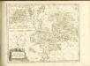
Tabulae Marchionatus Brandenburgico-Culmbacensis sive Baruthini Pars Superior cum adjacentibus Regionibus exhibita
1 : 180000 Mollova mapová sbírka Riediger, Johann Adam Seutter, Matthäus
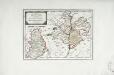
Tabulae principatus Brandenburgico-Culmbacensis sive Baruthini
1 : 225600 Bavorsko severní (Německo) Riediger, Johann Adam Lotter, Tobias Conrad I.A. Riediger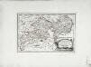
Des Herzogthums Oberpfalz nördliche Pfleggerichte mit der gefürsteten Grafschaft Sternstein
1 Karte : Kupferdruck ; 18 x 27 cm Reilly F. J. J. von Reilly