Maps of Wunsiedel

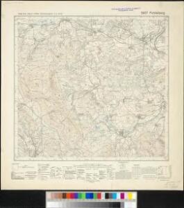
Meßtischblatt 5937 : Fichtelberg, 1940
1 : 250000 Fichtelberg. - Aufn. 1936, Ausg. 1937, bereinigt 1940. - 1:25000. - München, 1940. - 1 Kt.
Asch
1 : 75000 Aš (Česko : oblast) Ansion K. u. k. Militärgeographisches Institut
Asch
1 : 75000 Aš (Česko : oblast) K. u. k. Militärgeographisches Institut
III. vojenské mapování 3948
1 : 75000
III. vojenské mapování 3948
1 : 75000
Aš
1 : 75000 Aš (Česko : oblast) Vojenský zeměpisný ústav
Aš
1 : 75000 Aš-oblast (Česko) Vojenský zeměpisný ústav
Bavaria 1:50,000, Tirschenreuth (West)
Bavaria 1:50 000, Series GSGS 4492. Great Britain. Ordnance Survey. [London] : War Office
Asch.
from Spezialkarte der osterreichisch-ungarischen Monarchie.
142. Plauen (bijgeschreven: Löbenstein), uit: Topographische Uebersichtskarte des Deutschen Reiches / herausgegeben v. d. Kartogr. Abt. d. Königl. Preuß. Landesaufnahme
1 : 200000 titelvariant: Topogr. Übersichtskarte des Deutschen Reiches; Annotatie: Titel boven bladen ook: Topogr. Übersichtskarte des Deutschen Reiches; Annotatie geografische gegevens: Op elk blad twee maatstokken: 10 Kilometer = 5,5 cm; 1 geogr. Meile = 3,6 cm; Legenda onder op elk blad Königlich Preußische Landesaufnahme. Kartographische Abtheilung [S.l : Königlich Preußische Landesaufnahme, Kartographische Abtheilung]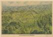
Franzensbad und Seine Umgebung

Generální mapa ČSR

Bamberg 101, uit: Special-Karte von Mittel-Europa / nach amtlichen Quellen bearbeitet von W. Liebenow
1 : 300000 titelvariant: W. Liebenow's Mittel-Europa; Annotatie: Titel boven de bladen: W. Liebenow's Mittel-Europa Johannes Wilhelm Liebenow 1822-1897 Frankfurt a. M. : Ludwig Ravenstein
Tabulae Marchionatus Brandenburgico-Culmbacensis sive Baruthini Pars Superior cum adjacentibus Regionibus exhibita
1 : 180000 Mollova mapová sbírka Riediger, Johann Adam Seutter, Matthäus
Tabulae principatus Brandenburgico-Culmbacensis sive Baruthini
1 : 225600 Bavorsko severní (Německo) Riediger, Johann Adam Lotter, Tobias Conrad I.A. Riediger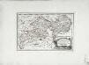
Des Herzogthums Oberpfalz nördliche Pfleggerichte mit der gefürsteten Grafschaft Sternstein
1 Karte : Kupferdruck ; 18 x 27 cm Reilly F. J. J. von Reilly
TERRA ADVOCATORVM | Vulgo | VOIGHTLAND
Descripta ab Olao Ioannis Gotho | S.R.M. Sueciæ Geographo. Amstelædami | J. Blaeu excudebat.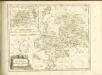

Carte topographique d'Allemagne contenant une partie du royaume de Boheme, une partie de la Saxe
1 Karte : Kupferdruck ; 46 x 61 cm Jaeger; Hauer se vend chez I. W. A. Iaeger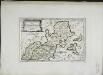
Des Bisthums Bamberg nördliche Aemter
1 Karte : Kupferdruck ; 19 x 29 cm Reilly F. J. J. von Reilly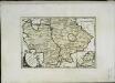
Des Bisthums Bamberg südliche Aemter
1 Karte : Kupferdruck ; 20 x 30 cm Reilly F. J. J. von Reilly
Sac. Rom. Imperii principatus & episcopatus Bambergensis nova tabula geographica
1 : 215000 Bamberg-oblast (Německo) Homann, Johann Baptist á Io. Bapt. Homanno
Sacri imperii Romani circuli et electoratus Bavariæ, 1
1 Karte : mehrfarbig ; R. et J. Ottens
Sac. Rom. Imperii principatus [et] episcopatus Bambergensis nova tabula geographica
1 Karte : Kupferdruck ; 47 x 56 cm Homann Johann Baptist Homann
Sac. Rom. Imperii principatus [et] episcopatus Bambergensis nova tabula geographica
1 Karte : Kupferdruck ; 47 x 56 cm Homann Johann Baptist Homann
S. R. Imp. Circuli Franconici Geographica Delineatio Francken-Land mit Seinen Gräntzen
Mollova mapová sbírka Endter, Wolfgang Moritz Endter, Wolfgang Moritz
Tabula Geographica Novissima Principalis Episcopatûs Bambergensis
1 : 260000 Mollova mapová sbírka Seutter, Matthäus Seutter, Matthäus
Palatinat. Superior sive Bavariae, Germanice Die Obere Pfaltz
1 : 310000 Mollova mapová sbírka Seutter, Matthäus Seutter, Matthäus
Bayern II.
1 : 650000 Radefeld, Carl Christian Franz, 1788-1874