Maps of Grafenwöhr

Meßtischblatt 6237 : Grafenwöhr, 1938
1 : 250000 Grafenwöhr. - Aufn. 1905/23, Ausg. 1927, Erkund. 1937, bericht. 1938. - 1:25000. - München, 1938. - 1 Kt.
Meßtischblatt [6236] : Eschenbach i.d. OPf., 1933
1 : 250000 Eschenbach i.d. OPf. - Aufn. 1930, Ausg. 1932, Nachtr. 1933. - 1:25000. - München: Topograph. Zweigstelle d. Bayer. Landesvermessungsamts, 1933. - 1 Kt.
Meßtischblatt 125 : Erbendorf, 1933
1 : 250000 Erbendorf. - Aufn. 1922, 23, Ausg. 1928, Nachtr. 1933. - 1:25000. - Topograph. Zweigstelle d. Bayer. Landesvermess, 1933. - 1 Kt.
Meßtischblatt 125 : Erbendorf, 1928
1 : 250000 Erbendorf. - Aufn. 1922, 23, Ausg. 1928. - 1:25000. - [München]: Bayer. Topographisches Bureau, 1928. - 1 Kt.
Meßtischblatt 124 : Kemnath, 1933
1 : 250000 Kemnath. - Aufn. 1922,25, Ausg. 1929, Nachtr. 1933. - 1:25000. - [München]: Topograph. Zweigstelle d. Bayer. Land, 1933. - 1 Kt.
Bavaria 1:50,000, Tirschenreuth (West)
Bavaria 1:50 000, Series GSGS 4492. Great Britain. Ordnance Survey. [London] : War Office
154. Bayreuth, uit: Topographische Uebersichtskarte des Deutschen Reiches / herausgegeben v. d. Kartogr. Abt. d. Königl. Preuß. Landesaufnahme
1 : 200000 titelvariant: Topogr. Übersichtskarte des Deutschen Reiches; Annotatie: Titel boven bladen ook: Topogr. Übersichtskarte des Deutschen Reiches; Annotatie geografische gegevens: Op elk blad twee maatstokken: 10 Kilometer = 5,5 cm; 1 geogr. Meile = 3,6 cm; Legenda onder op elk blad Königlich Preußische Landesaufnahme. Kartographische Abtheilung [S.l : Königlich Preußische Landesaufnahme, Kartographische Abtheilung]
Meßtischblatt 166 : Kaltenbrunn, 1928
1 : 250000 Kaltenbrunn. - Aufn. 1905/1925. - 1:25000. - München, 1928. - 1 Kt.
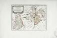
Tabulae Marchionatus Brandenburgico-Culmbacensis sive Baruthini Pars Superior cum adjacentibus Regionibus exhibita
1 : 180000 Mollova mapová sbírka Riediger, Johann Adam Seutter, Matthäus
Tabulae principatus Brandenburgico-Culmbacensis sive Baruthini
1 : 225600 Bavorsko severní (Německo) Riediger, Johann Adam Lotter, Tobias Conrad I.A. Riediger
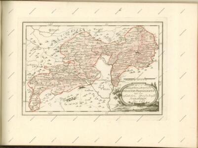
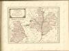
Des Herzogthums Oberpfalz nördliche Pfleggerichte mit der gefürsteten Grafschaft Sternstein
1 Karte : Kupferdruck ; 18 x 27 cm Reilly F. J. J. von Reilly
Das Fürstenthum Sulzbach und die Landgrafschaft Leuchtenberg
1 Karte : Kupferdruck ; 19 x 28 cm Reilly F. J. J. von Reilly
Sacri Romani imperii circuli et electoratus Bavariae tabula, 1
4 Blätter : s.n.
Sacri imperii Romani circuli et electoratus Bavariæ, 1
1 Karte : mehrfarbig ; R. et J. Ottens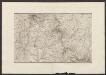
Militair Karte von Süd-Deutschland in 20 Sectionen
1 : 400000 7. Section Coulon, Alois von A. von Coulon
Bavariae Palatinatus vulgo Die Ober-Pfaltz in Subjacentes ejusdem Praefecturas aceuratissime divisus
1 : 300000 Mollova mapová sbírka Visscher, Nicolaes Schenk, Peter II
Palatinatus Bavariae vulgo Die Obere Pfaltz in omnes ejusdem Status et Praefecturas accuratà divisus
1 : 310000 Mollova mapová sbírka Homann, Johann Baptist Homann, Johann Baptista
Palatinat. Superior sive Bavariae, Germanice Die Obere Pfaltz
1 : 310000 Mollova mapová sbírka Seutter, Matthäus Seutter, Matthäus
Principatvs Brandenbvrgico-Cvlmbacensis vel Barvthinvs. Tabvla Geographica qvoad Partem Svperiorem experssvs
1 : 180000 Mollova mapová sbírka Homann, Johann Baptist Homann, Johann Baptista - dědici
Generalkarte von Zentraleuropa


Carte topographique d'Allemagne contenant le Haut Palatinat, une partie du royaume de Boheme, de la Basse Baviere
1 Karte : Kupferdruck ; 46 x 61 cm Jaeger; Facius I. W. A. Iaeger ches qui cette carte se vend
Deutsche Strassenprofilkarte für Radfahrer
Furth im Wald (Německo) Mittelbach's Verlag
Generální mapa ČSR

Normální mezinárodní letecká mapa.
Franzensbad und Seine Umgebung